Hillockburn trail to the south fork clackamas falls attempt
Hillockburn trail to the south fork clackamas falls attempt
Today I attempted to reach the south fork clackamas river falls. I found the trail refrence on oregonkayaking website and the guys who ran the river spoke of 2 30 ft, 1 60 ft, and 1 100ft waterfalls in the 2.6 mile stretch from where the trail meets the river to the main clackamas river. The trial was a pleasant grade and nice old growth forest was the setting. The trail ended 100 yards shy of reaching the river due to multiple fallen trees and debris. I turned north parallel to the river and began bushwaching. The river was lined with dense brush and thornes and 5 minutes in the thicket pushed me uphill. an hour later I found myself over 1000 up and steep drop after drop so after studying the topo map and gps I realized there wouldn't be a break in the terrain for awile so I headed up the hill without those coveted shots of the falls. I have been at the other end of the south fork at the confluence of Memaloose creek and photographed a unique 50-75 ft falls with a big long tunnel about 40-50 yards long and 8ft tall above it last year. I think this may have been one of the falls on Memaloose. I will post some pics of that trip from last year but for now all I have is a couple from today. I may go back tomorrow and try upstream from the mouth. Cheers
- Attachments
-
- does anybody know what this flower is?
-
- indian paintbrush
-
- these kept popping up everywhere

Re: Hillockburn trail to the south fork clackamas falls attempt
The falls and tunnel you describe are the lower falls on the South Fork. The 120 foot waterfall is just upstream from the tunnel, but I'm not sure as to the logistics of reaching its base.
Re: Hillockburn trail to the south fork clackamas falls attempt
Here are the images from my trip May 18th of last year to the lower end of the south fork.
- Attachments
-
-
-
-
ken leibert
- Posts: 42
- Joined: December 15th, 2008, 10:15 pm
Re: Hillockburn trail to the south fork clackamas falls attempt
Does the water get low enough latter in the summer to wade and swim the river and rappel all of the waterfalls?
Ken Leibert
Ken Leibert
Re: Hillockburn trail to the south fork clackamas falls attempt
Well, I take back my previous statement. That is the falls on Memaloose Creek. I didn't know there was a tunnel up there as well.
-
Splintercat

- Posts: 8333
- Joined: May 28th, 2008, 10:03 pm
- Location: Portland
- Contact:
Re: Hillockburn trail to the south fork clackamas falls attempt
Ken, the answer is yes, based on the flows coming out at the mouth. I've only seen photos of this canyon, as well. Pete Giordano has explored many of these canyons, and describes a tunnel along the route to Memaloose as well as the tunnel past the main falls on the South Fork. The kayaker narrative describes a trail (likely and old road) from both tunnels down to the mouth of the South Fork, so following it upward might work.
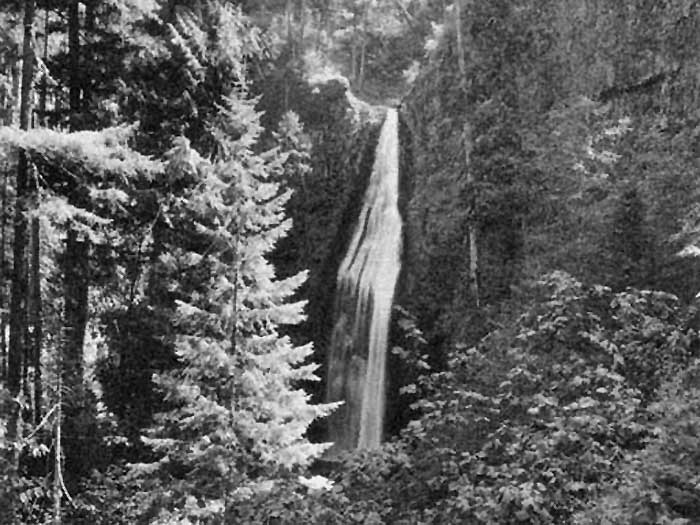
Here's a 1959 view of the main falls, presumably from the old roadbed leading to the tunnel:
Here's a 1963 view of the lower falls, also presumably taken from the old roadbed:
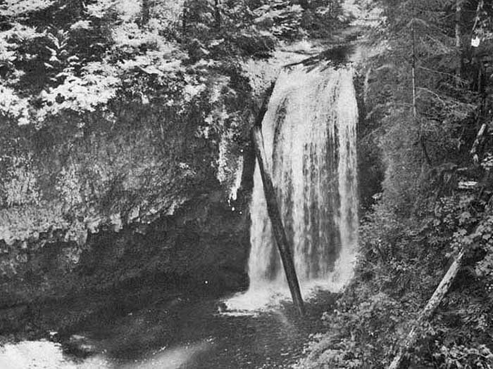
Both look to be summer images, with relatively low flows.
-Tom
Here's a 1959 view of the main falls, presumably from the old roadbed leading to the tunnel:
Here's a 1963 view of the lower falls, also presumably taken from the old roadbed:
Both look to be summer images, with relatively low flows.
-Tom
-
madisonhikers
- Posts: 8
- Joined: June 29th, 2008, 9:23 pm
Re: Hillockburn trail to the south fork clackamas falls attempt
That "flower" is candystick(common name). I believe it's not actually an orchid, but one of those "other" designations you find in some of the guide books. My experience is they're not as common as other "real" orchids. Great picture!
-
FuelFunnel
- Posts: 1
- Joined: July 14th, 2009, 3:10 pm
Re: Hillockburn trail to the south fork clackamas falls attempt
Fallguy:
My brother and I were exploring around here mid May of this year. We finally decided to cross the big Clackamas with the canoe and enter the area from the mouth of the South. It was a little brushy, but fairly easy on the old abandoned roads. We first crossed the bridge near the Memaloose and went up that fork a few hundred feet past the tunnel you have pictured there and the road basically ends. We were looking for a possible alternative in/out of this area and heading up hill somewhere near these coordinates looked the most dooable at least from the bottom. (45.18617,-122.22267) It also looked as if someone may have headed up at the lower end of the tunnel also. We then headed back down to the bridge and then up the South Clackamas through the long tunnel that ends at the brink of the Clackamas Falls and the water collection structure.
I was curious as to how you entered the area last year in May because I have had people ask about how to get in here, and I would also like to go back again and don't really want the hassle of a boat if I can help it.
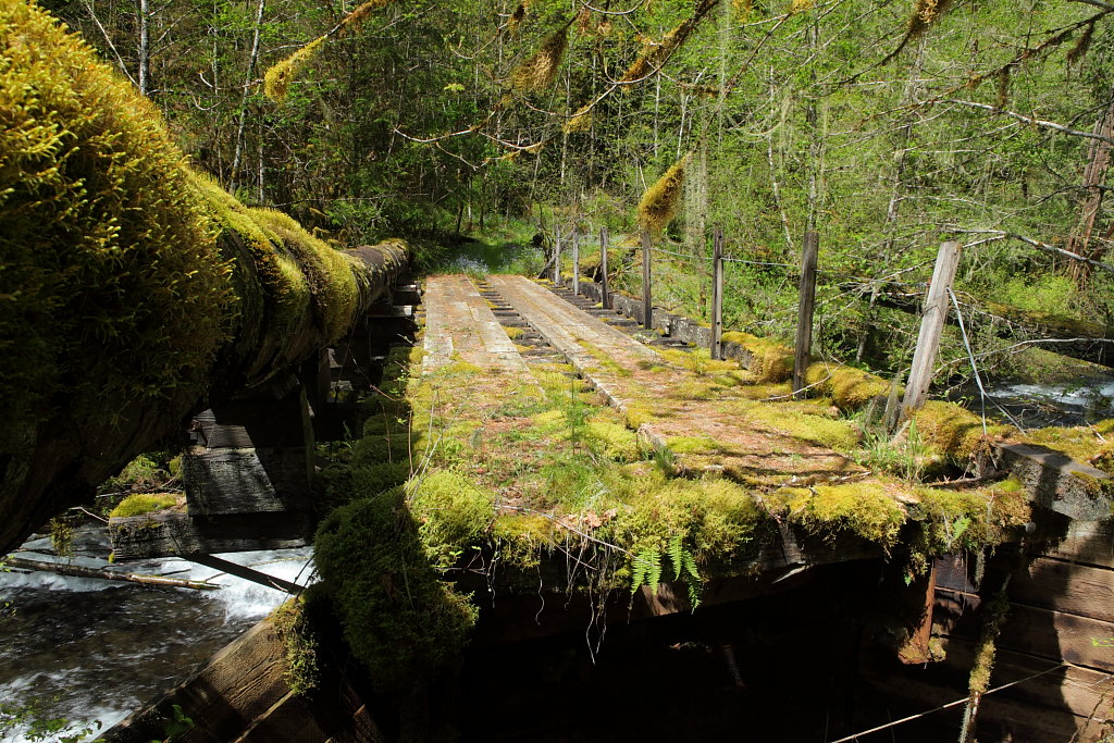
Here is a picture of the bridge that takes you up the Memaloose. My dog had a hard time here because the bank is starting to errode away on the East side.
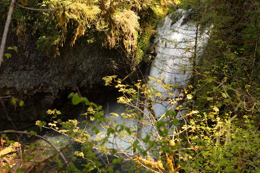
Here is the Lower Clackamas Falls in bad light and lots of brush. I could have gone down for a better view, but it was getting late. Note: My GPS showed this as being about .4 miles down stream from where it was supposed to be; and it was well BELOW the junction of the Memaloose--maybe Bryan Swan can double check the coordinates on this one.
Here are some other pictures of a few of the tunnels and the larger (main) falls.
http://www.panoramio.com/user/492864/ta ... as%20River
Kris
My brother and I were exploring around here mid May of this year. We finally decided to cross the big Clackamas with the canoe and enter the area from the mouth of the South. It was a little brushy, but fairly easy on the old abandoned roads. We first crossed the bridge near the Memaloose and went up that fork a few hundred feet past the tunnel you have pictured there and the road basically ends. We were looking for a possible alternative in/out of this area and heading up hill somewhere near these coordinates looked the most dooable at least from the bottom. (45.18617,-122.22267) It also looked as if someone may have headed up at the lower end of the tunnel also. We then headed back down to the bridge and then up the South Clackamas through the long tunnel that ends at the brink of the Clackamas Falls and the water collection structure.
I was curious as to how you entered the area last year in May because I have had people ask about how to get in here, and I would also like to go back again and don't really want the hassle of a boat if I can help it.
Here is a picture of the bridge that takes you up the Memaloose. My dog had a hard time here because the bank is starting to errode away on the East side.
Here is the Lower Clackamas Falls in bad light and lots of brush. I could have gone down for a better view, but it was getting late. Note: My GPS showed this as being about .4 miles down stream from where it was supposed to be; and it was well BELOW the junction of the Memaloose--maybe Bryan Swan can double check the coordinates on this one.
Here are some other pictures of a few of the tunnels and the larger (main) falls.
http://www.panoramio.com/user/492864/ta ... as%20River
Kris
Re: Hillockburn trail to the south fork clackamas falls attempt
The coords I have on my site for the lower falls was just a guess. If you've got an accurate spot, I'll change it.
Re: Hillockburn trail to the south fork clackamas falls attempt
The easiest way I've found to get in there is by bushwhacking down the hill from FR 45 where it curves into the canyon of the South Fork. It is a straight shot to the mouth from here, and the bushwhacking isn't bad (just a steep slope with ferns). Dropping in above Memaloose looks steeper on the map, but it could be doable.