
In previous posts, including my TR of my accidental trip up Nesmith Ridge, I've commented that I think the standard route could use some improving. On 5/15/2016 I went back to investigate. Three problems discussed below:
1. Is there a better way to start the route, instead of continuing on an unmaintained extension of the Upper McCord Creek Falls trail? Related question: when descending, what happens if you stick to the ridge instead of veering right/east to McCord?
2. What's the best way to get above the obvious prominent vertical step that can't be climbed by 99% of our readers? There's a trail to the left/east (left assuming you're ascending the route) but it's now a maze of blowdown. Going right is about as bad.
3. A little beyond the step, the standard route leaves the crest, traverses more-or-less horizontally, then ascends steeply back to ridgecrest. Is this really necessary, or can a closer-to-ridgecrest route be established?
There are individual paragraphs on these problems below, so feel free to skip ahead if you don't want the story-of-my-day fluff.
COMPLAINT DEPARTMENT: WEATHER AND PARKING
Sunday was the better day to go hiking, per forecast. Didn't turn out that way. Raining when I woke at 3am, never stopped. Back to bed for a bit, then hours of indecision and anxiety, which did more to harm my weekend than the weather did. Consequently, started at 11:30, shockingly late for me.
Parking at Yeon was 100% full, so I parked on the shoulder, and others lined up behind me. In the rain? Seriously? I generally start so early and finish so late that I'm oblivious to parking issues. I guess this is normal now?
OTHER PARTIES
In spite of the parking situation, saw one person all day after I left 400 trail. I guess there must have been a big party at E falls. Or maybe a whole bunch of people did a Nesmith Ridge loop ahead of me. When I returned at dusk, the parking lot was empty. Eerie feeling. I didn't panic, because I remembered that I had been forced to park on the shoulder.
PROBLEM ONE: ACCESSING THE RIDGE
I've thought about going up Nesmith Point Trail a bit and looking for a way up, but bushwhacking up a wet jungle in the rain with a late start isn't my idea of fun. I went up the McCord trail, where I knew from previous observations that the terrain above and west of the trail is impassible (way too steep/brushy). So my intent was to go up to the falls and see what I could do from there. The railed overhanging-cliff trail was a nice respite from the rain. Mild temps, no wind to speak of, and clouds high enough to leave some decent views. Would be a great place to just sit and watch for a while, enjoying the dryness. But I had an agenda, so it was on to the falls. In case you're curious, the east lobe was flowing a bit in response to this rain, but not torrential. From the falls I took the standard trail towards Nesmith Ridge, and soon encountered the blowdown I was expecting. Last time, I went left (up) and continued to the ridgecrest, and on the way down followed the trail to the other side of the blowdown. This time, I spotted a trail lower, to the right. That's where I wanted to go, so it worked out well. The trail faded at a flattish clearing with a nice overlook to the west. To the north the ridge was broad and very brushy. To the west it dropped off precipitously. I got the feeling it wouldn't be practical to folow the top of the Kelly Cliffs (probably steep/brushy). To the south, up Nesmith Ridge, the topography was more distinct (defined ridge) but brushy, so I went back closer to the trail I lost at the clearing and looked for sensible routes up. Soon, encountered the trail. So really there's not much gap in the defined trail, it just fades a bit at the semi-flat clearing. Ascending the ridge, I half-way kept an eye out for the spot where the higher trail gains the ridge, but never spotted it. Not surprising, as when I took that route I flagged the ridgecrest as a reminder of when to get off crest and veer towards McCord on the descent (the fact that I flagged it before told me it wouldn't be easy to spot).
In conclusion, problem one was resolved to my satisfaction. I didn't establish a new exciting route, but I did find a new-to-me alternative, which I think is the "original" route, and which I consider to be a more pure route, gaining the ridge as low as practical.
PROBLEM TWO: THE STEP
On my earlier trip, I encountered a step that couldn't be ascended by a mountain goat, maybe not even by a sensible squirrel. I went right, and fought some ugly blowdown. Upon regaining the ridgecrest, realized the standard route (which I could see) goes to the left. Took that route when I went down, but it was almost as bad. This time, I wanted to ascend the ridge all the way up to the step and then follow the cliffs around to the right, well above the blowdown, and up the first gully I encountered. The traverse worked well until I rounded the corner and encountered some pretty bad blowdown. In steep terrain. Crap. Over/under/whatever soon brought me to the first gully, which angled back to the left a bit, towards the tip of the step. Getting to the gully was slightly tricky, and the ascent was steepish and semi-exposed. Not terrible, but if I was leading a group I'd toss down a courtesy rope (I just thought of that phrase "courtesy rope": a rope provided by the leader in a non-critical situation where a rope is a comfort/convenience rather than a necessity.) I topped out on the ridgecrest right across from where the standard route meets up.
In conclusion, problem two was resolved to my satisfaction, but just barely. I think this is the best way to get above the step, but it's a judgement call.
PROBLEM THREE: THE UNNECESSARY TRAVERSE
When the trail left the crest and started traversing horizontally, I looked up and saw steep brush and an imposing bouldery crest. It looked like an interesting possibility to explore, but in the rain with a late start, I decided to continue until the trail met the ridgecrest, and then see how far I could work my way down. If conventional wisdom is correct, I should fail, or I should get down a ways but realize the direction I'm going is so far off a sensible route that it's not a smart route to follow (e.g. maybe discover I was descending a spur ridge). Descending the crest was quite productive for a while. I did hit a pulpit that seemed like the end of the road, but right at the end, I could see at least a couple more tiers below, accessible with easy scrambling and/or very minor bypass routes to the side. The scenery was charming. I was having fun, and knew my ascent back up would be pleasant. Finally reached a point where I couldn't go any farther, not because it was too steep, but because the ridge faded out and got brushy. But the brush was low, and I could see where I would go, if I wanted to establish a trail. Barely though. The ridge was poorly defined here. So the question now was, could this crest be linked to a sensible Nesmith ascent, or was it only interesting as a side trip? One way, maybe the best way, was to bushwhack over and look for the trail... which I encountered immediately!
Conclusion: I can't say I established the perfect Nesmith route through the bypass section, but I did establish that there's a much better route than the standard, staying higher through more interesting scenic terrain along the ridgecrest, and it's accessible just a few feet off the standard boring traverse. Overall, problem three was resolved to my satisfaction, but there's still some work to be done at the lower stretches of the traverse.
CORKY'S CORNER: RELIEF AND MISERY
I slumped down on a rock at Corky's Corner, where Nesmith Ridge meets Nesmith Point Trail. I hadn't been watching the time at all, because I knew this route, and knew I could get down the normal trail in the dark, so there was no time anxiety. But of course I was curious, so looked. It was 6:00. What?! It took me 6.5 hrs from Yeon to Corky's Corner. Appalling. Shameful. For reference, Don Nelsen reports 2:48. But of course this trip wasn't about fast. I deployed the one luxury I lashed to the outside of my little fanny pack, a micro umbrella. I sat under it, chilly for the first time all day, maybe a little hungry and dehydrated (ironic, but you know how ridge routes are), and worrying about the minor head injury I sustained when exploring the traverse alternative. So yeah, a head injury on an off-off-trail route. My brother knew where I was going, but I wondered how long it would take SAR to find me. I actually told my brother in precise detail where I was headed, so at least they'd know to look for me (my body) on the crest. Getting to Corky's was a huge relief, as I was finally on a real trail. No cell signal, of course. The weather, maybe even more than my head, was demoralizing and discouraging. At least it wasn't terribly windy. With my head enjoying a break from the hat, I scrunched up under my umbrella and ate, nibbling at my ridiculously elaborate meal. I should know by now that when the weather sucks you need to carry simple snacks.
NESMITH TRAIL
Main thing that made my descent miserable was my wet squishy feet. My boots felt like buckets full of water. They're the most waterproof leather boots I've ever owned, and I wore my goretex gaiters, and I don't think it was raining hard enough for water to get wicked into my boots by my pants, so I don't know how they got that wet. In contrast, my low-tech golf jacket performed rather well, and even after 6 hours of nearly constant rain (and brushing against wet brush) I was fairly comfy from ankles to head. Second gripe was the pressure to get down before dark, but that was minor. It's not as if I was w/o a light source.
The trail was actually nicer than I remember. It's semi-charming. I hoped for a section of overhanging cliffs where the trail would be dry, and my wish was granted. For the first time since the McCord cliffs, I could relax, totally sheltered. Arrived at the Yeon TH at dusk, maybe 2 hours from Corky's, which was pretty much what my gut told me to expect.
ROUTE CONFUSION (DUDE, WHERE'S MY SADDLE?)
There were a couple surreal experiences where the trail didn't match my memory. I found myself on a section of trail that ran horizontally next to the ascending ridgecrest. That's exactly what I expected. But from my previous trip, I remembered this occurring after a couple undulations in the trail. The traverse started, in my memory and in my notes, after a saddle. I went back down and looked for it, but below the lowest part of the traverse, the trail just went down. Today, I found another report that said the traverse starts after a saddle, so I'm sure my memory is right. Maybe I just needed to go another minute to see it. Odd that I didn't remember going downhill into the saddle, but this wasn't new terrain for me, and the weather sucked, so maybe I just had a head-down approach, using the trail as just a means of transportation from problem 2 to problem 3, so didn't pay any attention to it.
My other twilight-zone experience was when I was rising from the traverse towards the ridgecrest and found myself in unfamiliar terrain. The trail was braided and impossible to follow. I wasn't even sure where I was, or where the trail was, but I knew it didn't look right. Of course, after the mysterious missing saddle, I shouldn't have trusted my memory. Spent a lot of time poking around, following anything that looked like a trail, using sticks and stones to mark my way. Finally decided to go way back down to known territory, where I recognized something, where I knew I was on route, and then try again, slowly and carefully. Aha! Missed a switchback. After figuring that out, it was clear sailing. If I had kept going up when I lost my way, I bet I would have ended up on the crest, but I'm the cautious type.
NESMITH RIDGE ACCOLADES FROM OTHER MEMBERS:
" it looks like a nice trail and will do so until it is too late to turn back...should you attempt this trail, you will be injured. It's just a matter of how bad it will be - scratches, scrapes, and bruises guaranteed."
- Pablo, 2007 [referring to a descent from Corky's Corner]
There were sufficient inconveniences that few stand out. That a section of trail along a sidehill collapsed under me so that I arrested myself by grabbing a passing tree, swinging around and digging my toes in, was just part of the Nesmith experience... I do enjoy following new routes, and difficulties make fond memories, but I cannot say that I feel any need to recommend Nesmith Ridge to anyone I like.
- Steve/Raven, 2007
PICTURES
None. Nesmith is a cool route, but not a lot that's terribly unique or photogenic, certainly not anything that isn't already easy to find if you search. And it was raining.
a better Nesmith Ridge
Re: a better Nesmith Ridge
Thx Chip for the TR and inspired by your study of the ridge I went up for a look-see myself. Like Rudolph Spur, Nesmith Ridge really got hammered this past winter although most of the damage is between 1600' and 1800'. There is very little of the original tread left in this section as upended root-balls have churned the soil and rocks into new challenges of scrambles, obstacles and route finding. Not a bad thing.
There is another change at the start of the trail and I'm going to say for the better. I believe since Chip went up early May a group of people (or at least one really dedicated individual) have done tread work on the section from Upper McCord Creek Falls to the ridge proper. And I mean a broad trail bench that was easy to follow all the way across that flat up there to just beyond where the ridge narrows. It stops there and the normal faint game trail like tread takes over.
Chip's item #1 - I suggest another visit as the tread from the falls to the ridge has been markedly improved.
On item #2, I've always gone climber's left and I did not recall anything too terrible through that section today but my memory is a little fuzzy. I should have GoPro'ed the whole thing.
On item #3 I am interested in Chip's contention that there is a shorter more ridge-centric route. I checked lidar and there is nothing that stands out as a problem. Once I'd made the ridge from the route-around I walked back to the north like I believe Chip did and took a peek down slope and while it is steep there are plenty of rock steps and trees so if there is an obstacle it is much further down the ridge. Probably worth an exploration. I've never liked the route around to regain the ridge.
McCord Creek is in low flow conditions.
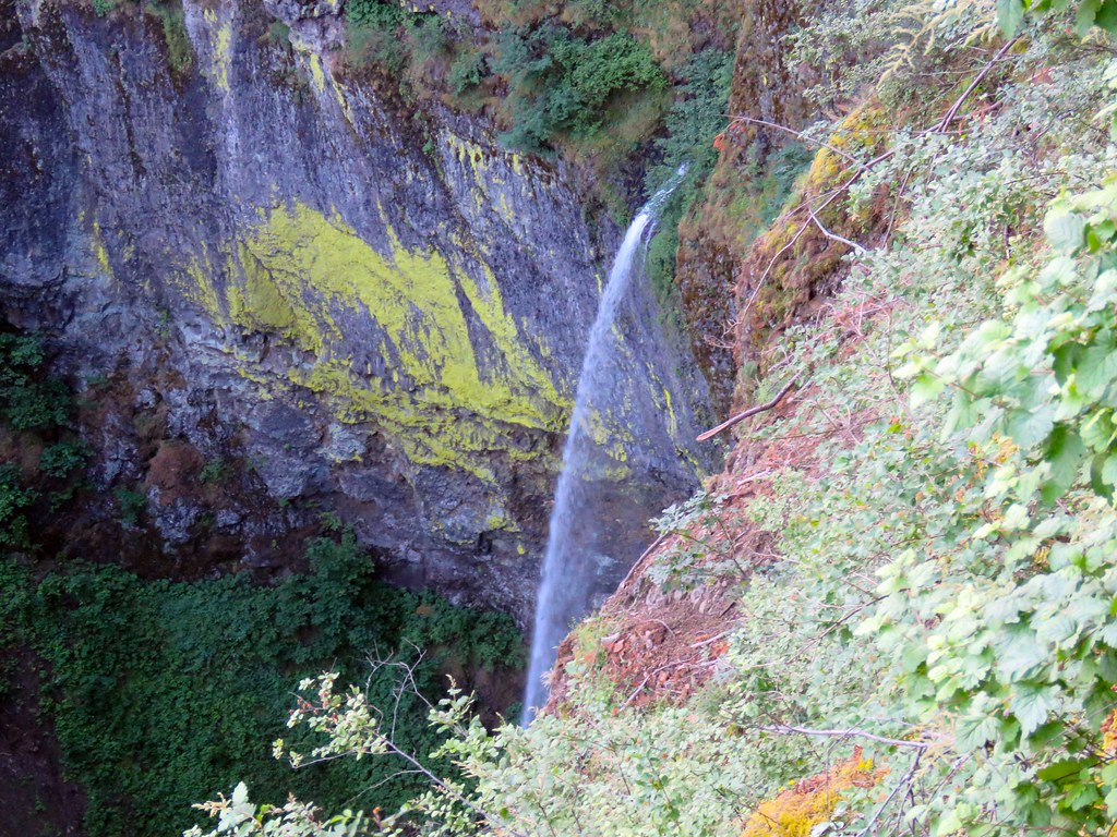 ElowahFalls
A bit of the re-conditioned tread coming out of Upper McCord Creek Falls to the flat.
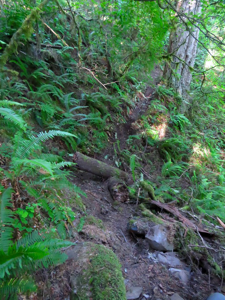 LowerTrail
Some of the damage going up, probably between 1600 and 1700'.
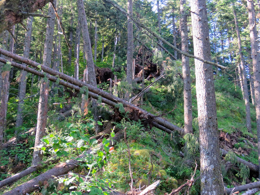 MessyRidge
Between 1700' and 1800' is a real tangle, some challenges here.
 DownedTrees
I'd say about 20-30 trees are down in this short section. One benefit, the downed trees have opened up some new views along the ridge.
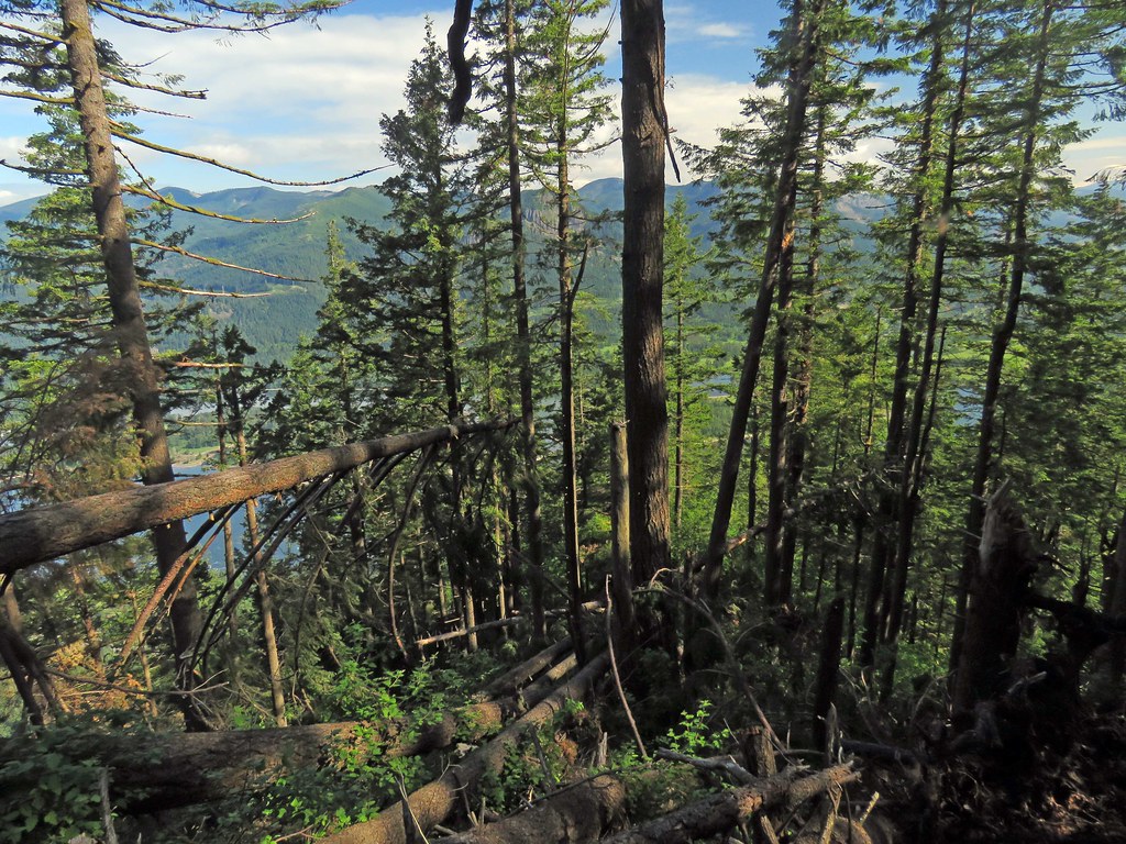
Hamilton Mtn
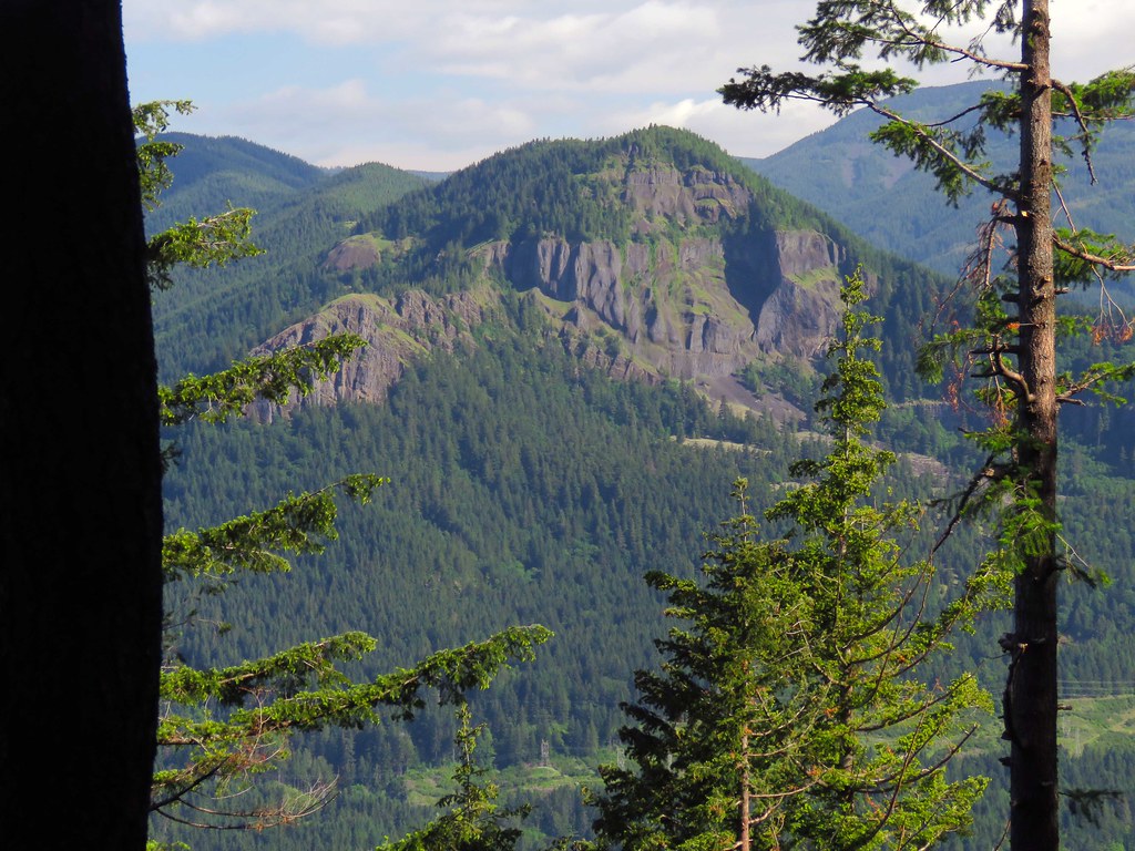 HamiltonMtn
Table Mtn
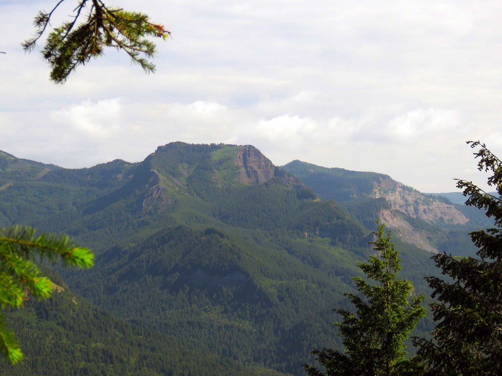 TableMtn
The view at 2400' is always good
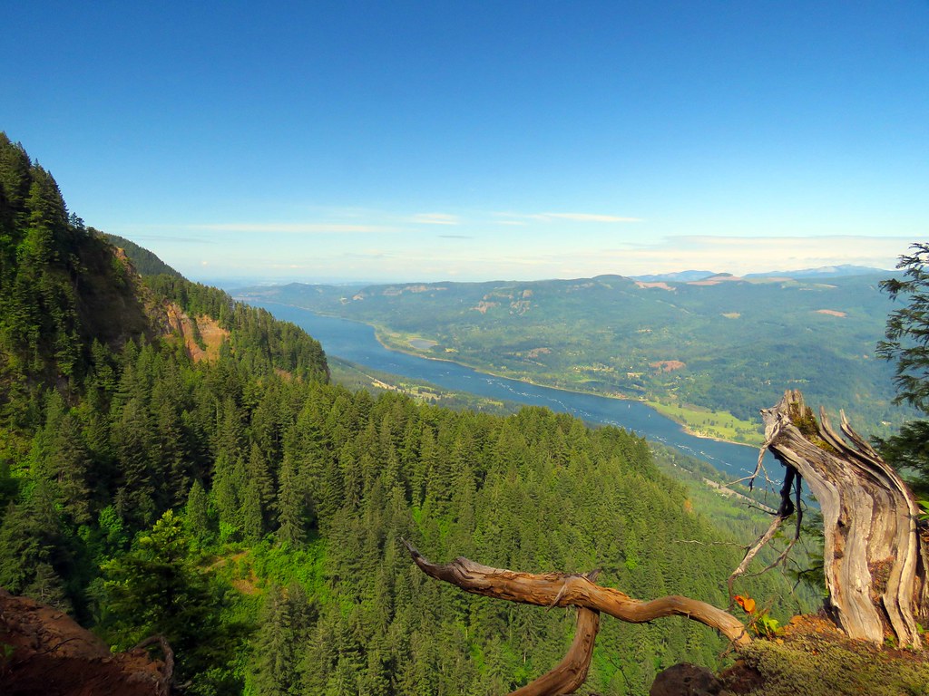 AboveCliff
There is another change at the start of the trail and I'm going to say for the better. I believe since Chip went up early May a group of people (or at least one really dedicated individual) have done tread work on the section from Upper McCord Creek Falls to the ridge proper. And I mean a broad trail bench that was easy to follow all the way across that flat up there to just beyond where the ridge narrows. It stops there and the normal faint game trail like tread takes over.
Chip's item #1 - I suggest another visit as the tread from the falls to the ridge has been markedly improved.
On item #2, I've always gone climber's left and I did not recall anything too terrible through that section today but my memory is a little fuzzy. I should have GoPro'ed the whole thing.
On item #3 I am interested in Chip's contention that there is a shorter more ridge-centric route. I checked lidar and there is nothing that stands out as a problem. Once I'd made the ridge from the route-around I walked back to the north like I believe Chip did and took a peek down slope and while it is steep there are plenty of rock steps and trees so if there is an obstacle it is much further down the ridge. Probably worth an exploration. I've never liked the route around to regain the ridge.
McCord Creek is in low flow conditions.
ElowahFalls A bit of the re-conditioned tread coming out of Upper McCord Creek Falls to the flat.
LowerTrailSome of the damage going up, probably between 1600 and 1700'.
MessyRidgeBetween 1700' and 1800' is a real tangle, some challenges here.
DownedTreesI'd say about 20-30 trees are down in this short section. One benefit, the downed trees have opened up some new views along the ridge.
Hamilton Mtn
HamiltonMtnTable Mtn
TableMtn The view at 2400' is always good
AboveCliffThe future's uncertain and the end is always near.
-
[email protected]
- Posts: 250
- Joined: May 28th, 2008, 10:03 pm
Re: a better Nesmith Ridge
We went up Nesmith Ridge yesterday (6/08) and it was as grueling as ever. Yes, Pablo is right - great tread/trail from the falls at Upper McCord to the bottom of the ridge. And yes, the ridge trail in great shape EXCEPT for some big trees down right across the trail - lots of them. We did a work-around to the west avoiding most of the trees and cut a few branches and the like on the way up.
All in all, rather good now compared to when Pablo went up there and I agree, worth a re=visit but it remains a strong work-out no way around that.
All in all, rather good now compared to when Pablo went up there and I agree, worth a re=visit but it remains a strong work-out no way around that.