Salmon River Canyon: 3 of the Lower 4 Falls

Discussions and Trip Reports for off-trail adventures and rediscovering lost trails
Post Reply

Have you been to any waterfalls in Salmon River Canyon?

None
6
35%
Final Falls
2
12%
Frustration Falls
2
12%
Vanishing Falls
1
6%
Little Niagara Falls
3
18%
Split Falls
1
6%
Stein Falls
2
12%
 
Total votes: 17

The C-Ws
Posts: 337
Joined: May 28th, 2008, 10:03 pm
Location: SW Portland
Contact:

Salmon River Canyon: 3 of the Lower 4 Falls

Post by The C-Ws » July 3rd, 2008, 9:21 am

This trip was supposed to be a backpacking trip last weekend, but do to the heat we did it as 2 trips instead (Saturday and Wednesday). My original goal for Saturday was to get clear views of Frustration Falls by bushwhacking downstream from Goat Creek, but the time did not allow it. We hiked 4.5 miles in on the trail to Goat Creek Camp, Then bushwhacked down the creek 0.4 mile to the river.

Some scenes from Goat Creek:
Salmon River 012.jpg
Salmon River 018.jpg
Salmon River 022.jpg
For those who are looking at these pictures and wanting to be there, the easiest way is generally to rock hop down the creek. Goat Creek has many small cascades and falls, most of which can be easily downclimbed. Also, walking in the stream does the least damage to the vegetation.

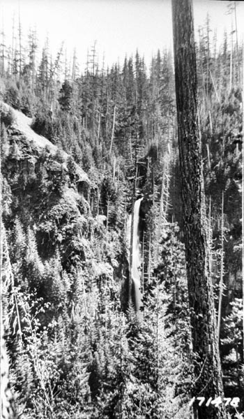
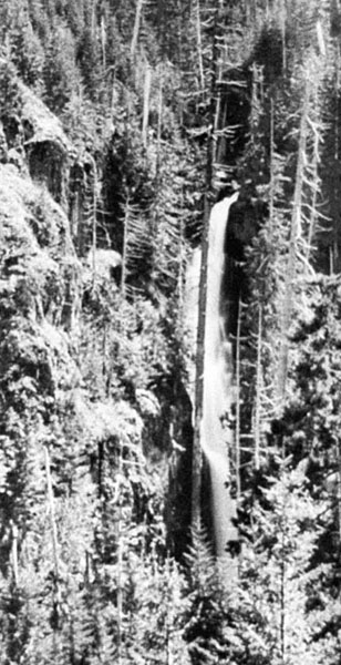
Upon reaching the confluence, we found a campsite with a fire ring. A trail leads out of the campsite and traverses along the canyon wall. Soon after taking the trail, we passed above Little Niagara Falls and bushwhacked off the trail down a brushy slope to a viewpoint of the falls:
Salmon River 006.jpg
We were running out of time, so we turned around and headed back to the trailhead. However, the trail we were following continued past Little Niagara. My guess is that it forks soon after the falls, with one branch becoming the side trail that descends steeply downhill from the main trail a little ways before Goat Creek and the other branch traversing the canyon walls and joining with the network of user trails around Final and Frustration Falls. I'll have to explore it another day.

Not having success with the lower 2 falls on saturday, we returned Wednesday to view them from the canyon rim. We took the first major side path after the viewpoint loop. It steeply descended an open ridge with nice views down the canyon:
Salmon River 009.jpg
We followed the trail to where it curves away from the ridge and begins its traverse toward Frustration Falls. We could see Little Frustration Falls from here, and we could glimpse Upper Final Falls:
Salmon River 017.jpg
Salmon River 054.jpg
We could not, however, see Final Falls, so we scrambled down the exposed slope below the trail, following a use path down a short, steep gully to a viewpoint of Final Falls and Upper Final Falls:
Salmon River 024.jpg
Salmon River 043.jpg
Another shot, showing the exposure of the viewpoint:
Salmon River 031.jpg
We scrambled back up to the trail and followed it past three viewpoints of Frustration Falls.

The first viewpoint, showing the base of the falls:
Salmon River 061.jpg
The second viewpoint, showing the bottom 40 feet through the trees:
Salmon River 080.jpg
The third viewpoint, showing most of the falls, minus the bottom 20 feet:
Salmon River 112.jpg
After the third viewpoint, the trail climbed steeply to a junction. We followed the trail to the left, which climbed out of the canyon to the main trail. The trail to the right continued to traverse the canyon walls, possibly connecting with the trail out of the Goat Creek campsite? I'll have to come back and follow that one soon, hopefully catching a glimpse of the elusive Vanishing Falls...
Casey

User avatar
Splintercat
Posts: 8333
Joined: May 28th, 2008, 10:03 pm
Location: Portland
Contact:

Re: Salmon River Canyon: 3 of the Lower 4 Falls

Post by Splintercat » July 3rd, 2008, 10:20 am

Hmm... that additional spur trail sounds interesting. It might have developed with the kayaking interest in the canyon. Did you consider checking out Vanishing Falls while you were down there? Your description of the canyon in the Goat Creek vicinity sounds more brushy than I remember, but it has been a LONG time since I went down there. I definitely concur with simply walking down the creek bed.

Casey, you might have seen these already, but I posted a bunch of images from a pair of 1983 trips that pretty similar to yours -- plus some images from when the waterfalls were named in 1963. Here's the link:

Waterfalls of the Salmon River Gorge

I noticed that you've got Little Niagra downstream from Goat Creek - my recollection (when I put the map on the website together) had been that Little Niagra was upstream, and Vanishing downstream. But that certainly looks to be Little Niagra in your photo, and I don't recall any additional drops of that size between Little Niagra and Vanishing from my trip. I do remember a big splash pool with a lot of floating wood debris in it, just below the lower left area in your photo.

There is one more waterfall in the area that was named during the 1963 trip - Hideaway Falls on Tumbling Creek. This is a photo that I copied from the USFS files back in the early 80s. It was labeled "Hideaway Falls", and the geography fits the map location - here's the original photo, plus an enlarged section:

Image

Image

I've not been to this one, and it's definitely not for the aged! So I am going to have to live vicariously through whoever bushwhacks in there to see it -- Casey, put this one on your list..!

Tom :)

The C-Ws
Posts: 337
Joined: May 28th, 2008, 10:03 pm
Location: SW Portland
Contact:

Re: Salmon River Canyon: 3 of the Lower 4 Falls

Post by The C-Ws » July 4th, 2008, 8:15 am

Little Niagara Falls is shown upstream of Goat Creek on my topo map, but I figured out from the kayaking description and videos that it was downstream. And yes, the corner of the splash pool is still full of wood. I got within a hundred yards of Vanishing Falls, but do to the time and the fact that my mom had been scratched it the eye by a badly placed twig, we turned around and left it for next time.

Any idea how the USFS got to Hideaway Falls? Did they cross the river or bushwhack down from Linney Creek? I saw a report that there is no bridge across the river at the Linney Creek trailhead. Do you know if it is possible to cross without a boat? That would make for much easier access to Split and Stein Falls.
Casey

User avatar
Don Nelsen
Posts: 4380
Joined: May 28th, 2008, 10:03 pm
Location: Vancouver, WA

Re: Salmon River Canyon: 3 of the Lower 4 Falls

Post by Don Nelsen » July 4th, 2008, 11:14 am

Great report and thanks for putting this together. I've hiked the trail as a loop a couple of times but never down to the falls so now its on my too-long to-do list!
"Everything works in the planning stage" - Kelly

"If you don't do it this year, you will be one year older when you do" - Warren Miller

User avatar
Splintercat
Posts: 8333
Joined: May 28th, 2008, 10:03 pm
Location: Portland
Contact:

Re: Salmon River Canyon: 3 of the Lower 4 Falls

Post by Splintercat » July 4th, 2008, 7:52 pm

That's good question about fording at the old Linney Creek bridge site - my guess is that it would be fine when water levels are lower. I haven't been on that road in ages, so have no idea how well it is holding up. But it would definitely give you a head-start on the upper waterfalls.

I don't think the Oregon Geographic Board subcommittee visited any of the waterfalls above Vanishing or Little Niagra, if those. Years ago, while researching for the 1983 trip, I interviewed one of the 1963 expedition members (Thomas Vaughan) and his recollection was very poor: he didn't remember using ropes, nor how they had gotten to the ledge opposite Frustration Falls. My theory is that they descended Goat Creek, then worked their way all the way down to the ledge across from Frustration (and at the base of Little Frustration). They were aided by the fact that water levels were low.

As far as the error on the USGS map, that is probably my fault, too! At about the same time that we went on the two trips in 1983, a person (now deceased) named Howard Rondthaller at Mount Hood National Forest was collecting "update" info for the USGS on features within the forest. I had talked to him about the trip, and he asked for a sketch map of the waterfall locations. When I saw the new 7.5 minute quads, they were exactly where I had placed them -- including my poor memory of where Little Niagra is located! You'd think at the ripe age of 21, I wouldn't have already been experiencing premature dementia..! ;)

Casey, be sure to check out Oregon Geographic Names for the history of the waterfall naming. I mention some of it on my web pages, but the original explorers were locals in the Welches area. They may be the only people who have actually been to Hideaway Falls. I don't think the Oregon Geographic Names Board had quite the same rigor in locating features in those days, since a full-blown survey with transit would be required to do what we're able to do with a pocket GPS unit. So I'm guessing the subcommittee visit and subsequent vouching of the existence of at least some of the waterfalls was enough. The other wrinkle is that the only USGS coverage in 1962 were the 15-minute map series, so LOTS of room for map error!

One more factoid for you, Casey: that "bridge to nowhere" at the Salmon River Trailhead was once envisioned as continuing the Salmon River Road all the way up the canyon, connecting to Highway 26 at Salmon River Meadows. Thankfully, that never happened, and never will, thanks to the 1984 creation of the Salmon-Huckleberry Wilderness. The wilderness bill also likely killed a river-level trail, something that I've always wished for the area, since it's a world-class river in close proximity to Portland. But I'll take the current trail up on the canyon wall over a highway, any day!

-Tom

Post Reply