On friday I went out to a few waterfalls in the starvation area: lindsey creek falls, then made a loop around to the big falls on summit creek, camp benson falls.
You park along the freeway where a dirt road leads up into the forest just past milepost 53. Then, we followed the road passed a junction w/ the old wagon road and stayed left at a junction just passed there, under the powerlines. this road continues up and around a few towers then heads thru the woods. We followed this route until a small path was visible heading down to the creek bed, which we took.
once at the creek you bushwhack about ten minutes up to the falls. I'll post some more pictures of the creek when i am done editing, but for now here is the falls:
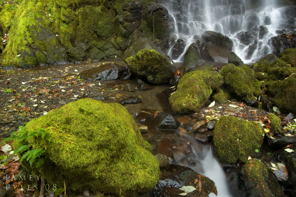
Next, we headed back to the first junction right beyond the gate (the old wagon road). we headed west from there on the wagon road to its end, overlooking the highway. from here we pushed through some fir trees following a faint trail and ended up in a big open spot at the base of some huge cliffs. Continuing west, the route dips in to the summit creek canyon, and is from there on a goat path. Right as we entered the trees on this path we could see a nice little falls down below. Following Casey's route we dropped down into the canyon. heres that little falls (i call it fern falls):
from here we could faintly see the big falls(camp benson) above. we zigzaged across the creek a few times up and around big huge boulders and up a nice steep fern covered slope, and eventually made it to the base of Camp Benson Falls. While I photographed the waterfall my hiking partner scouted a way out up the top of the canyon to the left. here is a few pictures:
quite an intriguing falls! so, to get out of here, we climbed up the side of the canyon to the left, which involved some exposure. at the top we explored about 1/4 mile into the upper canyon, but didnt find the upper falls... next time! the road which goes under the powerlines from the top of the falls took us down to the junction where we originally turned left to get to lindsey creek falls. from there its a short downhill walk back to the car!!
great day exploring, and i havent had as much fun as that in quite a while!!
Lindsey Creek Falls and Camp Benson Falls 11-28
Jamey Pyles
Re: Lindsey Creek Falls and Camp Benson Falls 11-28
Camp Benson looks a whole lot better at low flow than I thought it would. Nice shots.
I think someone needs to get in there and slice a little path into that steep hillside because going down that first 5-10 feet that gets you from the powerline clearing to the base of the falls is just a little too sketchy.
Re: Lindsey Creek Falls and Camp Benson Falls 11-28
yeah.... i would like to see the high flow version someday too....
how far back is the upper falls?
Jamey Pyles
- Splintercat
- Posts: 8334
- Joined: May 28th, 2008, 10:03 pm
- Location: Portland
- Contact:
Re: Lindsey Creek Falls and Camp Benson Falls 11-28
Nice photos, Jamey! I agree with Bryan, Summit Creek looks surprisingly good with low water. I need to get back to Lindsay Creek next spring in a "normal" year -- we got pounded last June with the runoff from the high snowpack. I wasn't able to shoot any images from the perspective that you shot, and instead, focused on the slope to the west.
Tom
Tom
Re: Lindsey Creek Falls and Camp Benson Falls 11-28
I'd say no more than 500 feet upstream from where the powerline road runs into Summit Creek. Pretty easy to get up there too - stay close to the creek and you can make it up there in about 5 minutes. Its pretty but really just a consolation prize.pyles_94 wrote:yeah.... i would like to see the high flow version someday too....
how far back is the upper falls?
Re: Lindsey Creek Falls and Camp Benson Falls 11-28
man, i must have been real close when i turned around... im pretty sure i went 3 or 400 feet in...
Jamey Pyles
Re: Lindsey Creek Falls and Camp Benson Falls 11-28
Jamey,
Those are beautiful areas! How far have you been up/down Lindsay creek? I'm thinking of hiking up and bushwhacking the entire 5 or 6 miles...any idea what to expect?
Also, I really like your idea of Illahee (sp?) for a waterfall on Moffett. I'm the one who gave Apocolypse it's name (because the year I went up there had been massive upheaval/landslides for the 1/4 mile leading up to it), but never thought it was a good permanent name. So, I think Illahee would be a much better alternative. It would stay with the native name theme for the canyon - Wahe, Illahee, Kwanesum,...
-Zach
Re: Lindsey Creek Falls and Camp Benson Falls 11-28
thanks.... no ive never tried the whole thing, but i do however know that there is a nice 30 footer right next to the highway. i would expect more falls up there....
i have no idea how you could get around lindsey creek falls, though!
Jamey Pyles