Hey Bryan,
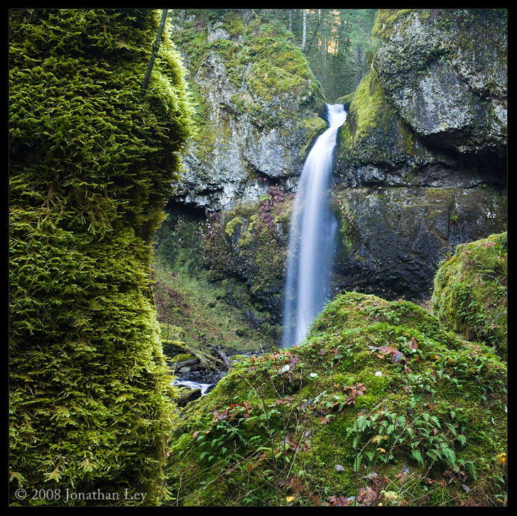
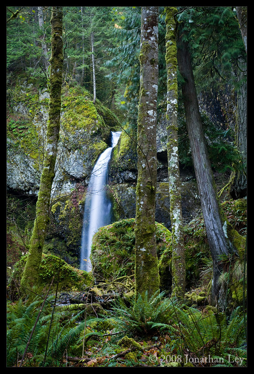
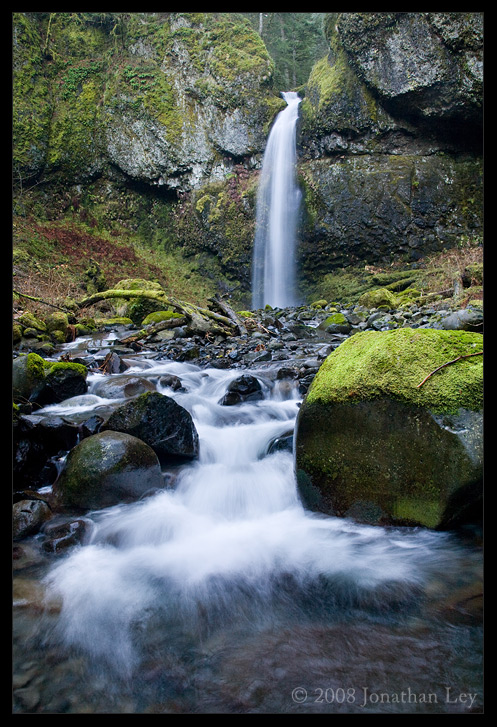
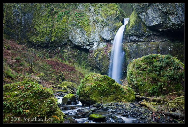
You're right...there remains that Ruckel mile or so...I'm thinking it's probably most likely a series of cascades rather than waterfalls, but it definately deserves a thorough check!! I'm hoping we'll get some more rain to get to check it out. I just remember going up Ruckel a couple years ago in late fall, and the whole stream amounted to no more than a trickle. Judging by how low Eagle is right now, I bet Ruckel's tiny.
Greys creek?...I haven't even heard of that! If it's small though, probably good to wait till spring. I'm thinking that with the water so low everywhere right now, Lindsay is begging to be explored! It seems to be substantial almost year round. Here are a couple of straggler images from Moffett I just found that I thought I'd add from this last trip. The first is Mt. Adams from a talus slope near the top of Moffett, and the second is the first falls, with Eliza taking down her tripod nearby.
Kwanesum and the falls of Moffett Creek
Re: Kwanesum and the falls of Moffett Creek
re: ruckle creek...
its at a moderate volume, as of last saturday:
i didnt go up crick from there but i had a few hours to shoot in the gorge and stopped by the lowerest falls on ruckle, then went to eagle creek.
its at a moderate volume, as of last saturday:
i didnt go up crick from there but i had a few hours to shoot in the gorge and stopped by the lowerest falls on ruckle, then went to eagle creek.
Jamey Pyles
Re: Kwanesum and the falls of Moffett Creek
Thanks Jamey,...Ruckel looks a bit fuller than I thought it would be right now...Given that, anybody up for a Sun/Mon Ruckel Ridge/Creek trip to fill in the gaps? I know it's a bit short notice - but if Bryan or anyone is up for it, let me know.
-Zach
-Zach
Re: Kwanesum and the falls of Moffett Creek
Zach, Grays Creek is the first drainage west of Gorton Creek, dropping north off of a small basin on Nick Eaton. You can't see it from 84 because it comes down the mountain where 84 butts up against that low hill before Wyeth. I've meant to take the Wyeth Road west towards Cascade Locks several times, but always ran into time constraints and felt my limited light could be spent elsewhere. If the topo maps are accurate, the Gorge Trail crosses the creek near where the bottom of the falls should be. Right around there the creek drops over 1400 feet in under half a mile. Simple physics says there's gotta be something.
- Splintercat
- Posts: 8333
- Joined: May 28th, 2008, 10:03 pm
- Location: Portland
- Contact:
Re: Kwanesum and the falls of Moffett Creek
Jamey, that second shot of Ruckel is one of the best I've seen - very nice! I'll have to remember to give that big log leaning against the falls a tug nest time I'm up there...
Bryan, the Gorge trail crosses the talus slopes on either side of Grays Creek, quite a bit upslope from the powerline corridor -- you've probably noticed that, if you looked at this via Google Earth (this are is just inside the decent resolution coverage). So the hike from Gorton Creek is probably the shortest path. Good find, if there is something up there! Seems promising, especially during high runoff.
Tom
Re: Kwanesum and the falls of Moffett Creek
I figured after reading all this, why start a new Moffett Creek thread? I went up there today, just to the first falls... simply because I hadn't been up there yet. Anyway, here are a few images:
Nothing special to note about this trip... just an excuse to get outside for a few hours.
Re: Kwanesum and the falls of Moffett Creek
jley wrote:I figured after reading all this, why start a new Moffett Creek thread? I went up there today, just to the first falls... simply because I hadn't been up there yet. Anyway, here are a few images:
Nothing special to note about this trip... just an excuse to get outside for a few hours.
jley
Great shots, I really like the perspective you've captured. I don't think I've seen this falls captured in quite the same way, thanks for sharing.
Jamie
Re: Kwanesum and the falls of Moffett Creek
Definitely great photos. I love the first one where the rocks cover the bottom of the falls. Leaves a little bit of mystery. Well done.
Re: Kwanesum and the falls of Moffett Creek
Excellent photos of Moffett Creek falls! I think my favorite is the angle you achieved viewing it through the trees. While the others have a bit "cleaner" feel, that shot is definately original, and gracefully accentuates the vertical nature of both the trees and the falls. Awesome job!!
-Zach
-Zach
- Navigator 2
- Posts: 47
- Joined: July 8th, 2009, 9:42 am
Re: Kwanesum and the falls of Moffett Creek
I'm totally blown away by this thread. I saw Moffett Cr. Falls 20 years ago, but didn't have a camera with me. Here's some misc. comments in response.
That "slide" between 2&3 looks like it's worthy of a # as well. You didn't mention how high it is, but it's really pretty. My favorite has got to be Wahe for form.
Tom, I agree about Warren Creek spilling over in recent years for the reasons you stated, plus that would explain the fresh greenery in your pix.
What's this rumbling I hear about a potential National Park? I'd go for that. Currently, Oregon only has one; we could use another, and what better place? Where do I sign?
Someone mentioned how brushy Warren Creek is. Those creeks are not only brushy, but much of that brush is poison oak. My friend got a bad case while trying to get a higher view of Lancaster.
I can see I'm going to be setting aside time each day to scope out this wonderful website.
Lynn