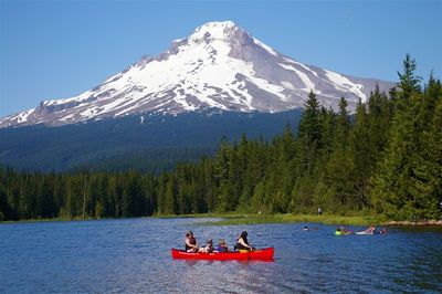
Trillium Lake Loop Hike
From Oregon Hikers Field Guide
- Start point: Trillium Lake Trailhead
- End point: Pond Lily Inlet
- Hike Type: Loop
- Distance: 1.9 miles
- Elevation gain: 10 feet
- High Point: 3,610 feet
- Difficulty: Easy
- Seasons: Summer into Fall
- Family Friendly: Yes
- Backpackable: No
- Crowded: Yes
Contents |
Description
Little Trillium Lake, with Mount Hood as an incredible backdrop, is one of the more popular day-use and camping destinations in the Mt. Hood National Forest. The roads around the lake are groomed for cross-country skiers in the winter. The lake itself is not natural: the boggy meadows here were submerged by a dam built across Mud Creek in 1960. The Trillium Lake Trail circles the lake and affords a visit, via a series of boardwalks, to its less-trafficked west shore, where a variety of wetland wildflowers can be observed in the summer. Note that this is one of the concessionaire sites (California Land Management) in the Mt. Hood National Forest, and you will have to pay a fee to park. Northwest Forest Passes are not valid.
From the day-use parking area, a paved trail leads to the shore from below the picnic shelter. Go left along the shore. The picnic area is shaded by mountain hemlock, western red-cedar, western hemlock, and silver fir. Cross a footbridge and then take boardwalk. This leads to the dam wall. A path leads along the shore below the dusty road. On any fair weather day in the summer, you will not have the place to yourself unless you do this walk early in the morning: other day-users will include paddle boarders, windsurfers, canoeists, boaters, inner tubers, kayakers, and swimmers. Mallards sun themselves on the dam rocks. The view of Mount Hood is a picture postcard scene. After the causeway, the trail leads right below the road into a willow thicket. It’s marked Trillium Lake Trail #761. Take a boardwalk into cedar woods with Engelmann spruce, silver fir, and mountain hemlock. Spurs lead right to the boggy shores. Hike another boardwalk and then pass through a parsnip, mertensia, thimbleberry opening. The path is lined with blooming subalpine daisies in mid-summer. A spur right leads to the lake. The trail winds through spruce-dominated woods and then reaches another boardwalk through willows, alders and then a cotton-grass meadow. Mount Hood peeks above the trees. Head into mountain hemlock/spruce woods with several little skunk-cabbage bottoms and huckleberry patches. A boardwalk crosses a sedge marsh. At a junction, a boardwalk spur leads right to a sedge swamp. Return to the trail in the woods and keep right at a junction. Another boardwalk winds through a cedar bottom. The human population increases as you near the campground. Spurs lead left to the campground as you keep along the lakeshore. Pass by Pond Lily Inlet with its yellow water lilies. Newts drift lazily in the still waters. Walk past an amphitheater and reach the campground boat launch. Go 30 yards to the left and pick up the trail again. There’s yet another boardwalk and then you reach the day-use boat launch (no motor boats allowed). At a junction, turn right on a paved trail to a floating dock that juts out into the lake. After this, go left up past the picnic shelter to day-use parking.
Fees, Regulations, etc.
- $5 day-use concessionaire fee (Northwest Forest Pass invalid): May 15th - October 1st
Maps
- Maps: Hike Finder
- Green Trails Maps: Mt Hood, OR #462 (Trail not shown)
- Adventure Maps: Mt. Hood Area
- Geo-Graphics: Mount Hood Wilderness Map
- U.S. Department of Agriculture, Forest Service: Zigzag Ranger District
- Discover Your Northwest: Mt. Hood National Forest North: Trail Map & Hiking Guide
- U.S. Department of Agriculture, Forest Service: Mt. Hood National Forest
- National Geographic Trails Illustrated Map: Mount Hood Wilderness
- National Geographic Trails Illustrated Map: Mount Hood
Trip Reports
- Search Trip Reports for Trillium Lake Loop Hike
- No Snowshoes Needed on Trillium Loop
- A Pedestrian Loop around Trillium Lake - 2016/01/01
- Bluebirdy day at Trillium Lake 8/6
- Trillium Snow shoe Jan 3
- Trillium Lake 7/29
- Room with a View at Trillium Lake 2/22-23
- Tamanawas Falls, Trillium Lake 8/2
- Trillium Lake Overnight Snow Shoe Backpack ~~ Dec. 29 - 30
- Trillium Lake 5/25/13
- Trillium Lake snowshoe/ First snow camp
- A Trillium (Lake)Thanksgiving 11/22
- Elk Meadows / Trillium Lake 8/15
- Another brutally rough day, Trillium Lake 7/25
- Trillium Lake
- Trillium Lake Trail 6/4
Related Discussions / Q&A
- Search Trail Q&A for Trillium Lake Loop Hike
- Trillium Lake parking
- Month by month... a year at Trillium Lake
Guidebooks that cover this hike
- Day Hiking Mount Hood: A Year-Round Guide by Eli Boschetto
- Afoot & Afield: Portland/Vancouver by Douglas Lorain
- Day Hikes in the Pacific Northwest by Don J. Scarmuzzi
- Oregon's Best Wildflower Hikes: Northwest Region by George Wuerthner
- 105 Virtual Hikes of the Mt. Hood National Forest by Northwest Hiker
- 60 Hikes Within 60 Miles: Portland by Paul Gerald
- Oregon: The Creaky Knees Guide by Seabury Blair, Jr.
- Trips & Trails: Oregon by William L. Sullivan
- Snowshoe Routes - Oregon by Shea Andersen
- The Dog Lover's Companion to Oregon by Val Mallinson
More Links
- Trillium Lake Loop Trail #761 (USFS)
- Trillium Lake Loop Hike (Northwest Hiker)
- Trillium, OR (Recreation.gov)
- Trillium Lake Campground (USFS)
- "Trillium Lake at Mount Hood could be the place to cool off this hot Portland weekend" (Oregon Live)
Page Contributors
- bobcat (creator)


