

Magness Tree Farm Loop Hike
From Oregon Hikers Field Guide
| This page is marked as a Closed Hike. Some or all of this hike has been closed by a governing body and hikers may be liable for fines or even arrest. At least part of this route may be dangerous and hard to follow, or it may cross areas with sensitive plant life or wildlife habitat. Trailkeepers of Oregon does not endorse or recommend hiking this route. When restrictions are lifted, this notice will be removed. |


- Start point: Magness Memorial Trailhead

- End Point: Heater Grove
- Hike Type: Loop with in and out
- Distance: 4.5 miles
- Elevation gain: 775 feet
- High Point: 590 feet
- Difficulty: Easy
- Seasons: All year
- Family Friendly: Yes
- Backpackable: No
- Crowded: No
|
Contents |
Description
NOTICE: The Magness Memorial Tree Farm has been closed to the public indefinitely.
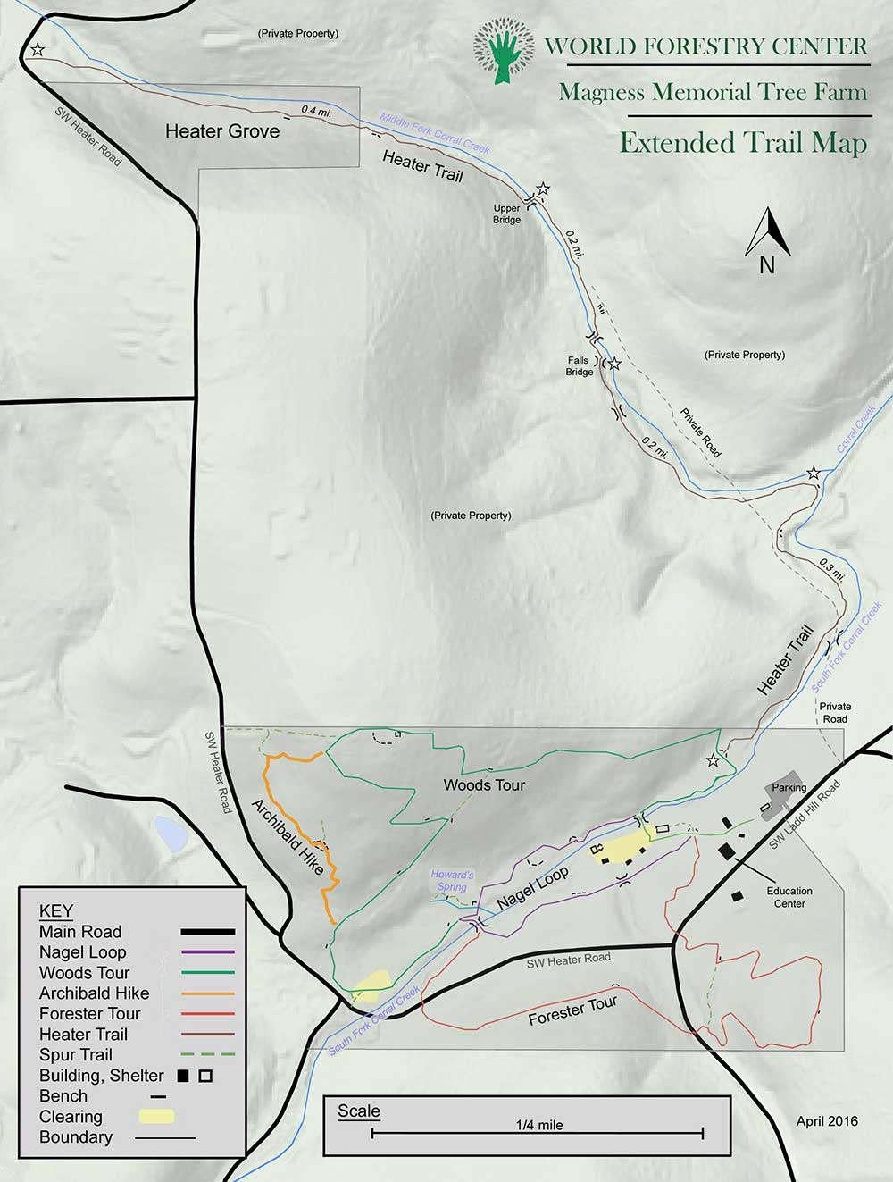
Between the confluence of the South Fork and Middle Fork Corral Creek on the southern slopes of Parrett Mountain in the Chehalem Hills, the Magness Memorial Tree Farm is a demonstration forest and outdoor education site managed by the World Forestry Center, an international non-profit based in Portland. The property is composed of two tracts: the main section was donated in 1977 by Howard and Panzy Magness, and the Heater Grove of western red-cedars was given in 1997 by the Heater family. The trail to the Heater Grove runs through private property, so visitors need to stay on the path in this section. Visits are free and the property is open all year but may be closed for private events. To take in most of the trails here, this description allows you to follow both the outer and inner loops as well as the in and out excursion to the Heater Grove. You will be hiking along the South and Middle Forks of Corral Creek in what is mostly secondary forest with some interpretive signs to explain natural history and forest practices.
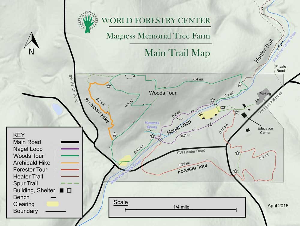
From the parking area, head towards the nearby buildings. Walk past the welcoming signs and the Caterpillar 75 diesel tractor on display. Then you'll pass the Edmund Hayes Education Center before coming to a four-way junction. Take the first trail on the left to begin the Woods Tour, named after former manager Rob Woods, to head up in a mossy Douglas-fir forest with sword fern, Oregon grape, vine maple, and young cedars and grand firs in the understory. Cross Ladd Hill Road and hike up the slope. The trail switchbacks to a bench and a junction. Go left here and switchback up twice. The trail levels at the border of the property and then drops steeply down. Note several orange-barked madrones to your right. Switchback to the left and drop to a junction. Make a left to cross Ladd Hill Road and a small stream. The trail traverses a brushy hillside and is verged with young Douglas-firs. Descend again to cross Heater Road.
The path now heads along the South Fork Corral Creek beneath big-leaf maples and white oaks. Reach the paved Nagle Trail, named after professional forester Dr. John Nagle. Go left across the South Fork on a footbridge, and turn left again on the paved trail. At a junction, leave the paved trail and head into a clearing planted with alders. The trail comes close to Heater Road and then heads uphill in a dense Douglas-fir plantation. At the junction with the Archibald Trail, go left and up, switchbacking four times. At the next junction, keep right and continue to ascend the slope. At the next junction, turn left and walk up to an old road bed. Here, go right and see a vineyard in the field to the left. Descend past foundation pads where the 60-foot Clatskanie Fire Tower used to stand: the tower was removed about ten years ago. From here, make four descending switchbacks and reach a junction.
Take the trail leading left that follows the creek under mossy maples and Douglas-firs. You’ll now be hiking across private property until you reach the Heater Grove, so don’t leave the trail. Reach an old vehicle bridge over an abandoned private roadway and go left. Soon, the trail splits off to the right from the grassy road bed. Follow the path as it winds along above the South Fork under cottonwoods, alders, and big-leaf maples. Invasive Armenian blackberry often hems in the path. Reach the road bed again at a bench and go right to follow the South Fork to its confluence with the Middle Fork Corral Creek. Keep hiking up the west bank of the latter, crossing a boardwalk. At a footbridge, you’ll get a good view of a 10-foot waterfall on the Middle Fork. Cross over to the east bank of the creek on a footbridge and take more boardwalks up along the edge of a clearcut. Cross back over the creek on a footbridge, and hike up the blackberry-choked creek noting some good-sized cedars on the slopes above. Rise up a wooded slope of red-cedar and Douglas-fir, passing a couple of benches and then reach creek level again. You’re now entering the Heater Grove, which is World Forestry Center property. The cedars here are not massive, but it is something of a miracle that they survived in an area that has been mostly clearcut and converted to farmland and viticulture. Some of the biggest specimens are right next to the trail. Pass through a small meadow, and join a grassy old road bed that leads out to Heater Road.
From here, you can return the way you came or take Heater Road back to the Tree Farm. If you choose the latter, you’ll walk up and over the crest of a hill and, heading down, pass a winery. Beyond the winery property, you see a metal gate at the boundary of a forested area. You can go past this gate and walk up the brushy road track. A connector leads down to the right to meet with the Archibald Trail, or you can continue until you come to the Woods Trail.
If you are returning along the Heater Trail, come to the junction with the Woods Trail and keep left to stay in the bottomland along the South Fork Corral Creek. At the next junction, stay right to hike up the north bank of the creek on the Nagle Trail. Across the creek are a pleasant sward, some attractive log cabins, and a covered picnic shelter. Interpretive signs inform about the human and natural history. Pass a large old grand fir and a Pacific yew before the trail drops slightly past a small cedar grove. A spur leads right to Howard’s Spring, which provided fresh water for the Magness family when they lived here. A pleasant grove of cedars shades this area at the base of a slope. Continue on the paved trail to pass the junction with the Woods Trail at a switchback and drop to a footbridge across the South Fork Corral Creek. Keep left after crossing, and reenter 80-year-old Douglas-fir woods to hike above the cabins and head straight out to the parking area.
Fees, Regulations, etc.
- Dogs on leash
- Open dawn to dusk
- Restrooms, picnic tables
Maps
- Maps: Hike Finder
- Magness Memorial Tree Farm: Extended Trail Map (World Forestry Center)
- Magness Memorial Tree Farm: Main Trail Map (World Forestry Center)
Trip Reports
- Search Trip Reports for Magness Tree Farm Loop Hike
Related Discussions / Q&A
- Search Trail Q&A for Magness Tree Farm Loop Hike
Guidebooks that cover this hike
- none
More Links
- Magness Tree Farm (World Forestry Center)
- Magness Memorial Tree Farm (Oregon.com)
- Magness Memorial Tree Farm and World Forestry Center (Grant’s Getaways)
- Magness Memorial Tree Farm (Sherwood) (Frugal Living NW)
- Magness Memorial Tree Farm: Hidden Treasure for Trail Runners (Portland Running Company)
- “Local Escapes: Magness Memorial Tree Farm (Portland Tribune)
Page Contributors
- bobcat (creator)