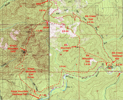
Elk Mountain Hike
From Oregon Hikers Field Guide
- Start point: Elk Creek Trailhead
- End point: Elk Mountain
- Trail log: Trail Log
- Hike type: In and out
- Distance: 3.2 miles round trip
- Elevation gain: 2080 feet
- High Point: 2788 feet
- Difficulty: Moderate
- Seasons: All year, depending upon winter snowfall
- Family Friendly: No
- Backpackable: No
- Crowded: Yes
Contents |
Hike Description
The hike to the summit of Elk Mountain gives you an elevation gain of about 2,000 feet in about a mile and a half. Thus, it is one of the steepest trails anywhere. The tread is narrow and, in places, slippery with gravel while there are several short but steep ups and downs. The rewards are great, however, with far-reaching views down the Wilson River valley and lots of hanging wildflower meadows. Whitened snags from the Tillamook Burn remind you that this area was once incinerated by one of the most intense fires in Oregon history. Once at the top, you may wish to continue farther, so consider the Elk Mountain Loop Hike or the Elk Mountain-Kings Mountain Loop Hike.
For the Elk Mountain hike, start just past the Elk Creek Campground. The road continues over a bridge to a parking area. There are two trails out of the trailhead. Take the Elk Mountain/Wilson River Trail up past a sign. The trail rises in lush woods under a canopy of red alder before a steeper section takes you to the Wilson River-Elk Mountain Trail Junction after 0.2 miles.
Here, go right (it's 1.4 miles to the summit) in a Douglas-fir, vine maple, salal, and sword fern woodland. The trail switchbacks, and you'll see large decaying stumps left from the Tillamook Burn. At a paintbrush/desert parsley meadow, there are open views to the west. Then head up steeply on a rocky spine to a clifftop viewpoint over Highway 6 and the Wilson River. The trail drops to a small saddle, and then rises precipitously again for more views. The old snags are now shaded by Douglas-fir, ocean spray, red huckleberry, and bracken. You'll drop to another little saddle and then continue steeply up. Scramble through a narrow cleft, and climb up another steep section of trail to get more views. The path drops to a saddle again, and then you’re ascending to get views to the east across a stand of alders. Drop a little, and then find your way up a short scramble section. Switchback to get more open views and keep steeply up. The trail levels on a Douglas-fir ridge with a 2,500 foot sign near a waterless campsite. Then you drop down the side of the ridge below a rocky outcrop. From here, you'll get your first view of the summit of Elk Mountain. Descend steeply to a saddle, and then head steeply up again. The path levels on a shady ridge, from which it’s a short hop up to the summit. Take in the great views to Kings Mountain across the forested bowl between the two peaks. Serviceberry blooms here in the spring, and tiger lilies display in early summer.
Sign the Mazamas summit register, and take care on the return down the steep trail. Going down, it's much harder to keep your footing and yourself upright!
Fees, Regulations, etc.
- Campground at trailhead
- Access road to trailhead gated in winter
- Check for snow levels before attempting this hike in winter; do not attempt this hike when it's icy!
Maps
- Maps: Hike Finder
- Kings Mountain, Elk Mountain & Elk Creek Trails (Oregon Department of Forestry)
- Oregon Department of Forestry: Tillamook State Forest Map & Guide
Trip Reports
- Search Trip Reports for Elk Mountain
Related Discussions / Q&A
- Search Trail Q&A for Elk Mountain
Guidebooks that cover this hike
- 60 Hikes Within 60 Miles: Portland by Paul Gerald
- 100 Hikes: Oregon Coast by William L. Sullivan
- Afoot & Afield: Portland/Vancouver by Douglas Lorain
- Day Hikes in the Pacific Northwest by Don J. Scarmuzzi
- 75 Scrambles in Oregon by Barbara I. Bond
- Take a Hike: Portland by Barbara I. Bond
- 50 Hiking Trails: Portland and Northwest Oregon by Don and Roberta Lowe
- 75 Hikes in Oregon's Coast Range and Siskiyous by Rhonda & George Ostertag
- Best Hikes Near Portland, Oregon by Fred Barstad
- 50 Hikes in the Tillamook and Clatsop State Forests by the Sierra Club, Oregon Chapter
- 50 Hikes in the Tillamook State Forest by the Tillamook State Forest Committee, Columbia Group Sierra Club
- Oregon Coast Camping & Hiking by Tom Stienstra & Sean Patrick Hill
- Pacific Northwest Hiking by Scott Leonard & Sean Patrick Hill
- Oregon Hiking by Sean Patrick Hill
More Links
- Elk Mountain (Summit Post)
- Adventure on Elk Mountain (Linda's Lens)
- Elk Mountain Out-and-Back (Hiking Project)
- Elk Mountain Hike, Tillamook Forest (Muddy Camper)
- Elk Mountain (Cascade Ramblings)
- "Elk Mountain is a tough little hike with outstanding Coast Range views" (Oregon Live)
- Elk & Kings Mountain (Northwest Wildflowers)
Contributors
- retiredjerry (creator)


