

Cottonwood Canyon Pinnacles Hike
From Oregon Hikers Field Guide

,_Pinnacles_Trail,_Cottonwood_Canyon_S.P..jpg)


- Start point: Murtha Ranch Trailhead

- End point: Pinnacles Seasonal Closure Barrier or Pinnacles Trail End
- Hike type: In and out
- Distance: 8.6 miles or 6.5 miles during the eagle nesting closure
- Elevation gain: 65 feet
- High point: 550 feet
- Difficulty: Moderate
- Seasons: All year
- Family Friendly: Yes
- Backpackable: No
- Crowded: No
|
|
Contents |
Hike Description
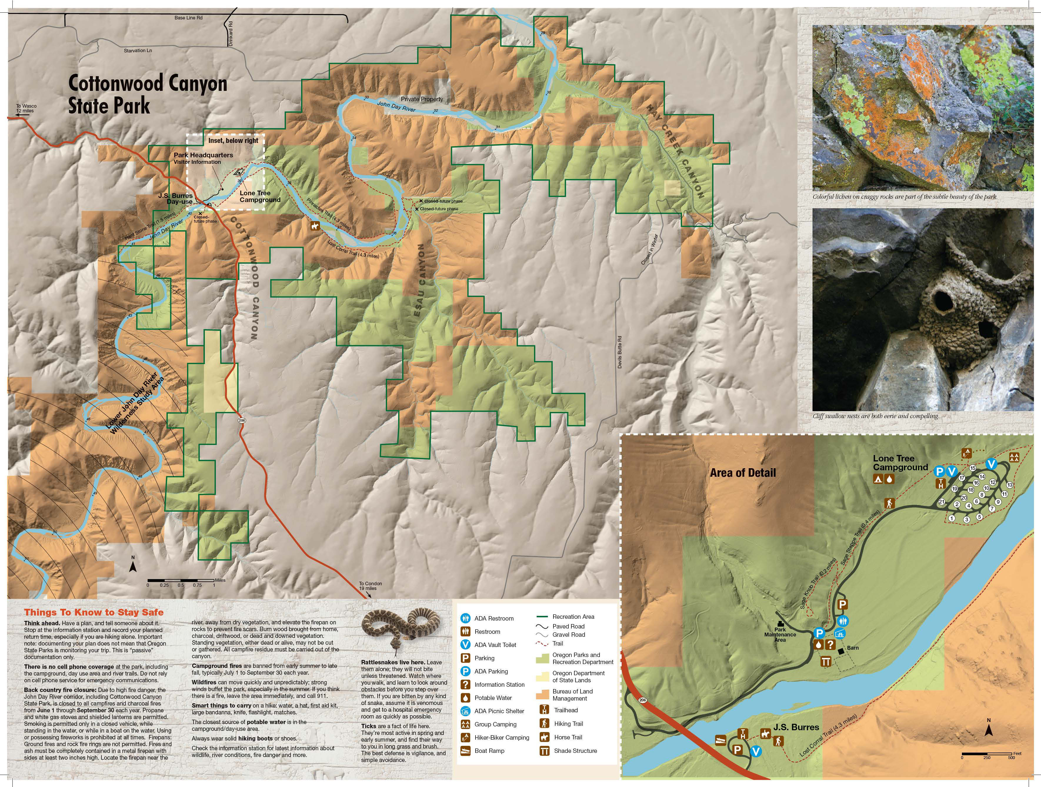
Cottonwood Canyon State Park is one of the newest additions to Oregon’s much admired state parks system. The park opened in 2013 and immediately became the second-largest in the state (Silver Falls State Park is the largest) at over 8,000 acres. Most of what is now the park was once part of the Murtha Ranch, a property that ran on both sides of the John Day River and encompassed a variety of habitats: river bottoms, canyons, basalt palisades, grassland, and sagebrush steppe. The park also hosts Oregon’s largest herd of California bighorn sheep – around 600 – 650 animals. There is a developed area, with campground, day-use facilities, and an interpretive trail. The river-level hike described here begins near the visitor center and follows one of the old ranch roads below colorful basalt cliffs and palisades through sagebrush flats until the tread peters out on the north side of a "gooseneck" peninsula.
Note that from February 1st through September 30th, the Pinnacles Trail is closed at Mile 3 because of nesting golden eagles. This point is at the end of the Gooseneck Peninsula, approximately opposite the Lost Corral. During these months, the hike is reduced to about 6.5 miles round-trip.
Cross the paved campground road and take a trail up to reach the junction with the Sage Steppe Trail. Go right here and hike along a slope looking down on a wide irrigated field. You can see camping cabins and restrooms with showers below. Near a parking area and restrooms, take a gravel trail which leads below a hiker/biker camp on your left. Pass along the edge of the Lone Tree Campground and reach a kiosk which displays a map, information about invasive puncture vine, and a trail register. This is also the Pinnacles-Willow Flats Trail Junction, with the wide path leading right continuing along the river to the Murtha Ranch buildings (see the Murtha Ranch Loop Hike).
Keep straight (left) here to pass through a fence near a large netleaf hackberry, which offers welcome shade in the heat of the day. You'll walk along a sagebrush flat where pungent desert parsley and prairie star bloom in the spring. Then pass by an enclosure in a field and the bottom of Gooseneck Gully to reach an overhanging basalt entablature where you can spot the nests of cliff swallows and, in spring, swarms of busy parents flitting to and fro. Pass an open gate and continue on the track, noting a user trail leading up slopes to the left. Hackberry trees line the bank of the John Day River. Basalt cliffs with a trickling waterfall rise above before you reach a four-way junction with the Upper and Lower Walnut trails. A spreading walnut tree offers shade. Take a left here to get a somewhat elevated view over the river. (On the return, you can take the Lower Walnut Trail along the shore.)
Heading up, you can see across to the willow-lined opposite bank of the John Day. Long-leaf phlox and woolly-pod milkvetch bloom trailside in the spring. You can see the Pinnacles Trail below passing a copse of white alder. Gently descend to rejoin the Pinnacles Trail at the Pinnacles-Upper Walnut Trail Junction and continue around a bend in the river that loops below the 1,000-foot-high Gooseneck peninsula (see the Gooseneck Loop Hike). (Another peninsula officially named the Gooseneck is farther upstream on the John Day and outside the state park.)
You'll pass below a dry gully and see basalt fortifications and an exfoliating pinnacle above as you pass through a gate. Continue hiking along below the grassy slopes at this wide bend in the river. Low cliffs opposite shade the Lost Corral. To its left is Esau Canyon and, straight ahead, you can get a view of the mouth of Rattlesnake Gulch with its intermittent waterfall. Under the basalt ramparts at the end of the Gooseneck, you'll reach the seasonal closure barrier across the track. From October 1st through January 31st, you can pass this to continue the hike. At other times of the year, you'll need to turn around.
You’ll notice a small bank of wind-rippled sand near a bench. The river braids here around a large willow bar, and you'll hike through tall big-leaf sagebrush and Scotch thistles. Red cliffs loom across the river to your right and there are high basalt walls ahead. Pass a gate post and walk below these cliffs, passing through a stand of poison hemlock. The river bank here is lined with golden currant, netleaf hackberry, and white alder. The track narrows and you’ll see a basalt pinnacle piercing the sky above. Blackberries close in on the track as you round a point at a riffle in the river. Soon reach an open green gate at the Pinnacles Trail End (around River Mile 34 on topo maps), and turn back.
For a more adventurous off-trail loop using the Pinnacles Trail as the return leg, see the Gooseneck Loop Hike.
Maps
- Maps: Hike Finder
- Cottonwood Canyon State Park (Oregon State Parks)
- Bureau of Land Management, Fish & Wildlife Service, National Park Service, USDA Forest Service: Lower Deschutes & John Day Rivers
Regulations or restrictions, etc
- Trail open all year for the first 2.5 miles; only October through January for the whole trail.
- Dogs on leash
- Share trail with cyclists
Trip Reports
- Search Trip Reports for Cottonwood Canyon Pinnacles Hike
- Cottonwood Canyon - Pinnacles Trail (Dec 31)
- Cottonwood Canyon trails - 2023-4-27
- CottonwoodCanyon - 2-29-2020 - Pinnacles Trail
- CottonwoodCanyon - 1-24-19 - Pinnacles Trail
- Cottonwood Canyon Pinnacles along the John Day River (3/30/18)
- CottonwoodCanyon - Pinnacles Trail - 2-22-17
- CottonwoodCanyon - 10-19-16 - Pinnacles Trail
- John Day River – Cottonwood Canyon State Park – 11/27
- Cottonwood Canyon – 12/14 – Pinnacles Trail
- Cottonwood Canyon 4-29-2014
- Cottonwood Canyon – March 8, 2014
- Cottonwood Canyon Backpack – 2/13-14
- Cottonwood Canyon 11/1/2013
- Cottonwood Canyon State Park, Oct 7-8
Related Discussions / Q&A
- Search Trail Q&A for Cottonwood Canyon Pinnacles Hike
Guidebooks that cover this hike
- 100 Hikes: Eastern Oregon by William L. Sullivan
- Oregon Favorites: Trails & Tales by William L. Sullivan
- Extraordinary Oregon! by Matt Reeder
- PDX Hiking 365 by Matt Reeder
- Oregon State Parks: A Complete Recreation Guide by Jan Bannan
More Links
- Cottonwood Canyon State Park (Oregon State Parks)
- Cottonwood Canyon State Park (Just Peachy)
- Cottonwood Canyon: The Pinnacles Trail (Sparrow Thoughts)
- Cottonwood Canyon State Park (wanderingyuncks)
- The Pinnacles (MyHikes)
- John Day River Pinnacles Trail (Outdoor Project)
- Cottonwood Canyon State Park (Wikipedia)
- "A colorful journey through Cottonwood Canyon" (Oregon Live)
- “Cottonwood Canyon State Park continues adding amenities, even green grass” (Oregon Live)
- “Cottonwood Canyon State Park plans ‘Taste of Oregon’s Old West’” (Oregon Live)
- John Day River Cottonwood Canyon (Western Rivers Conservancy)
- Cottonwood Canyon (Northwest Wildflowers)
Contributors
- bobcat (creator)