Portland Hikers ArchiveReturn to Portland Hikers Archive Cedar-Aldrich Falls - We did it... Posted by Jill (2008-02-16)
| ...half way anyhow.
After spying these falls last weekend from the summit of Hamilton Mtn and with today's plans gone awry early this morning, we decided to take a crack at this adventure. Although getting a late start, we were confident we could get this done. Afterall, we had the most perfect and complete information provided to us right here on this most excellent website so off we go.
Of course we parked at the resort, headed up the road, then started up the Dick Thomas Trail, thinking how lovely this hike must be in the summer when the trail is flourishing with greenery and alive with berries. If you know what I'm trying to say here! We made our way to the "lake" and crossed the little double log bridge which now has boards nailed perpendicular across them making it more of a makeshift bridge, which was cool with me since I usually spaz on log crossings. All was good and Table Mtn was cute as ever looking down over things.
We decided, of course, to make our way up to Aldrich Butte first for a "quick" lunch. Actually in hindsight, we ended up spending probably too much time up there exploring all the leftover paraphernalia, eating lunch, topo map studying and all the other such things one does on a summit. It was so nice up there today, warm sun, beautiful views... But we had to go find these falls.
We quickly descended and took off down the Cedar Falls Trail reaching Cedar Creek in no time. The creek was running fast and deep and it was quite the task not to step in water that would pour in over the tops of our boots but to my surprise we made it (twice) without soaking our socks a bit. Our little dog (who is actually still within the puppy age) was a bit wary of one section that was fast(er) running and deep(er) but she did us proud and hopped right over after a bit of persuasion.
We headed up the trail and there it was...
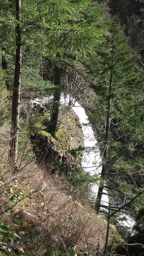
Determined now, we set off to see the rest of it. Passing by the junction of Cedar Mtn, we headed on down to Dry Lake Meadow. We get to the point that we decide to bushwhack down and I look at Dan, aka my hubby, and say; find the Cottonwood that looks out of place. He says what does a Cottonwood look like, and I reply that I don't know. So we set off to find a tree that looks out of place. We decide they all look the same and looked for the gully instead. We did find the gully and a trail so we took that and forgot about the dumb tree.
Of course we missed the trail to the left that was to be the bushwhack to the falls and after we realized we were so far down we decided to keep heading down to the creek bed. Shortly after, I found myself standing at the confluence of Cedar and Hamilton Creeks. How many people can say that? How cool. So wrapped up though in route finding, I didn't happen to take a picture and dang, I am upset about that. Hamilton Creek could be considered a river right now. It was incredible.
We started looking around a bit for the railbed but we didn't find it. Honestly, we didn't spend much time on that and since it didn't stand out like a sore thumb we decided to head back up the way we came which was incredibly steep and slippery but sort of fun in a twisted sort of way. On the way back up we spied the trail going off to the right, actually the left now for us, and suffering from a bit of A.D.D., we took off that way. We went quite a way when we started realizing that we were losing some of the obviously, taken for granted sunshine. At that point we decided that unless we wanted to navigate these somewhat obscure trails by headlamp we better just call it day and head back. So we did and never made it to the lower falls.
This my friends, was the saddest part of the day. These falls have probably not seen this much water in a long time and I had my chance and blew it. We are going back but most likely won't make it anytime soon. My advice to anyone else is go now and take a picture. The water levels are incredible.
That's it. It was plenty fun anyway. Thanks to everyone who contributed to the trail guide and to Jeff for his initial report when he found this route. Excellent work!
| Re: Cedar-Aldrich Falls - We did it... Posted by fettster (2008-02-18)
| Sounds like a rewarding day out. I was lucky enough to be taken on this bushwhack about a year ago with the experts themselves Jeff and Jim. Certainly there wasn't as much flowing then as what you saw. That would've been pretty cool.
The Cottonwood stands out because it is so big. I wish I had a picture of it now. Sounds like that's a must for the field guide. I imagine very few to none get to that creek confluence in a year. Thanks for the post. Brings back some good memories.
| Re: Cedar-Aldrich Falls - We did it... Posted by jeffstatt (2008-02-19)
| Hi Jill,
It is a real tough trail to track. I'm glad you made it to the confluence there. The "Trail" to the falls isn't much of a trail at all. In fact, I'd probably smart to change the wording in the Field Guide to "at some point, turn left". Sorry if I got you lost!! It is a neat area and it's great to see some more interest generated in it.
If anyone is interested I can plan an outing out there and show people the area? Perhaps in April sometime? |
Return to Portland Hikers Archive
Disclaimer:
Information found on PortlandHikers.org and PortlandHikersFieldGuide.org is
provided by website visitors and volunteers and should be considered anecdotal. All trails
and directions and subject to current conditions. Trails and roads can be rerouted due to
natural events and the website is not able to provide current information for every hike.
Please verify against two other sources before planning a trip. Outdoor activities present
inherent risks. Portlandhikers.org, nor any of its members, accept liability for injuries
relating to information found on this website.
|
Powered by phpBB © 2008 phpBB Group
|
|
© 2008 PortlandHikers.org - No content shall be copied or downloaded without permission
|
|
 |
