Portland Hikers ArchiveReturn to Portland Hikers Archive Dog Mountain 1-27-07 (Sorry, no pics) Posted by OneSpeed (2007-01-29)
| Okay, first the bad news: First time I pulled out my camera to take some pictures, I realized the battery was dead. So sorry, no pics.
Now the good news: Dog Mountain is totally hikeable and lovely right now!
I needed to get an accurate elevation profile for my book's new edition, and the Augsperger Mountain Trail doesn't appear on any maps I know of, so off I went -- to work off a big breakfast and see what the trail's like in January.
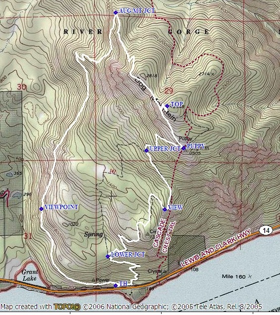
Here's the route: I go up the Augsperger Mountain Trail (left side of the map) and down the "scenic" version of Dog Mountain Trail, because I prefer going up a more gradual way.
There were about five cars in the trailhead, and I saw exactly five people on the trail: two on the way up, three on the way down. I like to go up the Augsperger Trail because it's about a mile longer and, therefore, less steep. It's 800 feet per mile, whereas the Dog Mountain Trail is 1,000 feet per mile. This is perfectly shown in the elevation profile, which also shows that both these trails are about as well-graded as a thing could be:
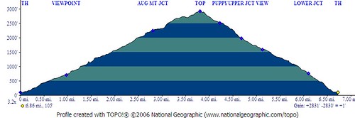
Note that the left side is the Augsperger Trail (3.9 miles to the summit) and the right is Dog Mountain Trail (the "scenic" route), which is 2.8 miles.
As for the conditions, there are no blowdowns on the trail at all. That might have changed Saturday, though, because it was WHIPPIN'. But the wind was funny Saturday: it seemed to be mostly out of the northeast, so at the trailhead it was swirling, mostly from the east. On the way up the west side of the peak, it was calm. When I hit the north shoulder of the mountain on the way up (around that little bump labeled "2818 on the map") and then Puppy Point on the way down, it was blowin' 40, about 30 degrees, and basically the kind of thing where you pull your hood over your head and just plow through it. But that was only a total of maybe 10 minutes the whole hike. Otherwise, I was in lightweight capilene top and bottom long underwear, lightweight pants, a fleece pullover, and for the most part just a fleece hat -- occasionally my windbreaker and gloves.
AND here's the thing: with the wind from the northeast, there was NONE of it on the summit! That's right, it was windier at the trailhead than on top of the mountain!
As for snow and ice, the top 500 feet of the mountain (so above about 2,500 feet elevation) is frozen solid, and there's a very thin layer of ice and snow on the trail. But I only slipped once, was hiking without poles, and only a couple of times felt like I needed to watch my step. All this, and the vegetation up there -- the trees, the grasses, the bushes, everything -- is frosted white. It's beautiful!
It's really too bad about the camera, but it makes me think more and more about getting rid of the thing and going completely "in the moment." Or at least getting a smaller, lighter one and selling the other one for a profit.
Anyway, Dog is open for business -- at least until the next snowfall!
| Re: Dog Mountain 1-27-07 (Sorry, no pics) Posted by OneSpeed (2007-01-29)
| And by the way, has anybody on here ever been over to Augsperger Mountain? It's like 15 miles from Highway 14, and I'm intrigued.
| Re: Dog Mountain 1-27-07 (Sorry, no pics) Posted by fettster (2007-01-29)
| I haven't been to Augsperger Mountain either, but am also curious to check it out.
From Aldrich Butte on Saturday it looked like Augsperger itself was right in or under some clounds and that Dog Mountain was very close to them as well. How was the view towards Hood River? We could see some of the frost on Table Mountain from a distance and it did look very pretty too! There was a very distinct line visible in the morning as to where it started elevation wise which was pretty cool.
It's funny how the summits can block the wind like that sometime. Given the wind in the gorge you would think there'd be at least some up there.
|
Return to Portland Hikers Archive
Disclaimer:
Information found on PortlandHikers.org and PortlandHikersFieldGuide.org is
provided by website visitors and volunteers and should be considered anecdotal. All trails
and directions and subject to current conditions. Trails and roads can be rerouted due to
natural events and the website is not able to provide current information for every hike.
Please verify against two other sources before planning a trip. Outdoor activities present
inherent risks. Portlandhikers.org, nor any of its members, accept liability for injuries
relating to information found on this website.
|
Powered by phpBB © 2008 phpBB Group
|
|
© 2008 PortlandHikers.org - No content shall be copied or downloaded without permission
|
|
 |
