Riverside Trail Hike
From Oregon Hikers Field Guide
- Start point: Rainbow Campground Trailhead
- End Point: Riverside Campground Trailhead
- Trail Log:
- Hike Type: Out and Back
- Distance: 7.8 miles round-trip
- Elevation gain: 575 feet
- High Point: 1,495 feet
- Difficulty: Moderate
- Seasons: Spring through Fall
- Family Friendly: Yes
- Backpackable: Yes
- Crowded: No
Contents |
Description
The Clackamas' Riverside Trail #723 is designated a National Recreation Trail and offers a relatively languid day's outing along its undulating course. Its low elevation makes it a suitable destination all four seasons of the year: you can observe steelhead migrations in the fall and winter/early spring, and the maples provide a brilliant yellow glow in October/early November. The month of June sees blooming rhododendrons and Clackamas white irises. The old growth is there to be admired all year. Campgrounds at either end and a couple of campsites along the way permit you to stay overnight. Also, this can be a good short hike and bike if you drop bikes at one of the campground trailheads.
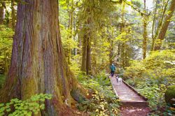
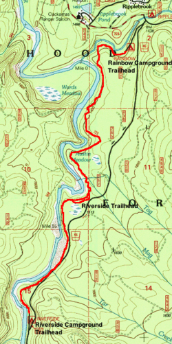
From the trailhead parking area at the Rainbow Campground, light out on the trail and cross a log bridge before passing a huge Douglas-fir. You'll pass over a small slough with little pools of water among the rocks. The Oak Grove Fork flows to the right as you hike under Douglas-fir, hemlock, vine maple, big-leaf maple and alder. The trail rises above a bluff, and you will get glimpses of the Clackamas River below. Wend through the woods and come to an overlook above the Clackamas. Keep right in a clearing with a fork in the trail, and drop to a boardwalk. Cross a footbridge, and head up before dropping again and then ascending under cedars, hemlocks and mossy Douglas-firs. Switchback down, and cross another footbridge. With the river to your right, squeeze between some large boulders, switchback, and descend. Cross the footbridge over Mag Creek, and hike up the slope: here, vine maple and big-leaf maple put on a spectacular display in the fall.
Pass the spur trail that leads to the Riverside Trailhead, which allows for midway access to the trail. Head up, then down with some views of the Clackamas. A spur right leads down to a campsite by the river. The trail rises to come close to the highway under a canopy of red alder. Wood fern, pathfinder, sword fern, salal, and Oregon grape form the carpet. Descend and cross a log bridge to the level of the river and a dry channel. Note the ancient yews under huge Douglas-firs in this old growth grove. The big-leaf maples turn bright yellow in the fall. Pass a big cedar, and then take a concrete walkway just next to the road over Tar Creek. There’s a nice beach by the river here. Undulate above a still section of the river under lichen-draped yews. In the fall, look for steelhead lingering in an emerald pool below. Soon reach the the Riverside Campground and turn around for the journey back.
Maps
- Maps: Hike Finder
- Riverside Trail #723 (USFS)
- Riverside Trail (Trail Advocates)
- Green Trails Maps: Fish Creek Mtn, OR #492
- U.S. Department of Agriculture, Forest Service: Clackamas River Ranger District
- Discover Your Northwest: Mt. Hood National Forest North: Trail Map & Hiking Guide
- U.S. Department of Agriculture, Forest Service: Mt. Hood National Forest
- National Geographic Trails Illustrated Map: Mount Hood
Trip Reports
- Search Trip Reports for Riverside Trail Hike
Related Discussions / Q&A
- Search Trail Q&A for Riverside Trail Hike
Guidebooks that cover this hike
- Hiking Mount Hood National Forest by Marcia Sinclair
- Afoot & Afield: Portland/Vancouver by Douglas Lorain
- 100 Hikes in Northwest Oregon & Southwest Washington by William L. Sullivan
- Best Old-growth Forest Hikes: Washington & Oregon Cascades by John & Diane Cissel
- 50 Hiking Trails: Portland & Northwest Oregon by Rob & Roberta Lowe
- A Walking Guide to Oregon's Ancient Forests by Wendell Wood
- Oregon Hiking by Sean Patrick Hill
- Pacific Northwest Hiking by Scott Leonard & Sean Patrick Hill
- Trail Running: Oregon by Lizann Dunegan
- Mountain Biking Oregon: Northwest and Central Oregon by Lizann Dunegan
- Canine Oregon by Lizann Dunegan
- Best Dog Hikes: Oregon edited by Falcon Guides
More Links
- Riverside Trail #723 (USFS)
- Riverside National Recreation Trail 723 (Trail Advocates)
- Riverside Trail (National Recreation Trails)
- Hike of the Season: Riverside Trail (Trailkeepers of Oregon)
- Clackamas Riverside Trail (Linda's Lens)
- "Riverside Trail is a picturesque hike along Clackamas River" (Statesman Journal)
- "The RiversideTrail: Uncrowded old growth forest on the other side of the Clackamas River" (Examiner.com)
- Riverside Trail (Oregon Adventures)
- Riverside Trail (Outdoor Project)
Page Contributors
- bobcat (creator)


