

Punchbowl Falls Park Hike
From Oregon Hikers Field Guide


,_Punchbowl_Falls.jpg)

- Start point: Punchbowl Falls Trailhead

- End point: East and West Forks Hood River Confluence
- Trail Log:
- Hike Type: In and out/loop
- Distance: 1.4 miles
- High point: 910 feet
- Elevation gain: 190 feet
- Difficulty: Easy
- Seasons: All year
- Family Friendly: Yes
- Backpackable: No
- Crowded: On summer weekends
|
|
Contents |
Hike Description
Trailkeepers of Oregon will host a work party at Punchbowl Falls Park on Saturday, September 23rd, 9:00 a.m. to 3:00 p.m.. Please sign up on the Trailkeepers Trail Work page.
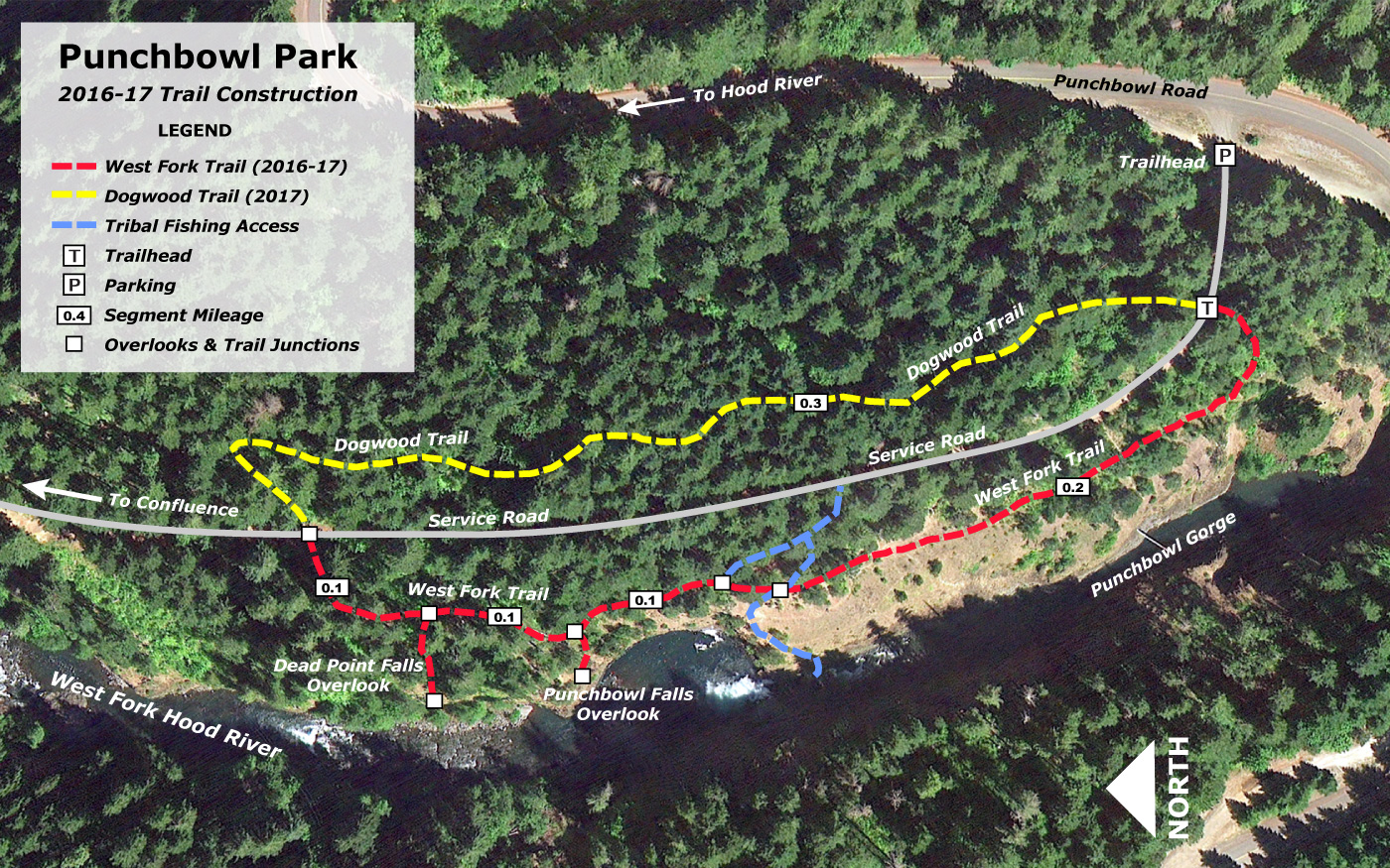
Trailkeepers of Oregon crews have constructed a short trail here on what used to be private land but saw regular infiltrations by the local youth in the summer. These 102 acres on the West Fork Hood River became a Hood River county park in 2016 after an initial acquisition by the Western Rivers Conservancy. You’ll enjoy an oak woodland, wildflower meadows, and a couple of waterfalls in a picturesque gorge. The hike ends at the confluence of the East and West Forks of the Hood River.
The trail departs from an old access road. Walk around a gate and pass a sign for the park. About 50 yards from the gate, you’ll see a path departing the road on your left (To the right, you can see flagging heading through the vine maples: this is the path of the future Dogwood Trail, which will complete a loop through the park in 2017/2018).
The West Fork Trail leads through an oak wood above the basalt-columned lower gorge of the West Fork. Lupine and Oregon grape verge the route. You’ll notice the rambling and decaying staircase dropping down the cliff on the opposite side of the gorge: this gave access to an ugly and intrusive fish ladder constructed in 1959 at Punchbowl Falls. Pass across a wet slope, which blooms with grass widow, saxifrage, buttercup, monkey flower, and larkspur during the spring. There are a couple of tie trails that lead back to the access road. Soon, the trail splits, with a lower section that passes along the edge of the cliff, while the main trail is routed behind an oak copse. Here, you’ll pass a shrine and cross that attests to the perils of these cliffs. You’ll arrive at a viewpoint almost directly above Punchbowl Falls, with a great view downstream to its magnificent amphitheater. Look upstream to see if the top of Mount Hood is visible. A trail leads down to the left to reach the river, crossing the lush seeps. This trail is sometimes used by tribal fishermen, who use ladders to reach the pool below Punchbowl Falls.
The trail leads up from this viewpoint and then splits left just before reaching the road. The path leads to a second oak-shaded viewpoint which gives you a frontal view of 10-foot Punchbowl Falls and its fish ladder/wooden staircase as well as a partial sighting of 75-foot Dead Point Falls plunging down a steep gully across the gorge. Above Dead Point Falls are the buildings of a fish hatchery, constructed in 1920 by the state but which then reverted to private ownership. The hatchery uses water from Dead Point Creek, which issues from the slopes below Mount Defiance, and then returns some of the flow via a side waterfall to the right of Dead Point Falls.
Take the trail back into the mixed woods of maple/Douglas-fir, and continue walking north. Just past a sign stating angling conditions for the West Fork Hood River, take a spur trail that leads out to the cliff edge and the best viewpoint for Dead Point Falls. After enjoying the scene from this perch, take the main trail out to the access road and go left. The road takes you through a thinned woodland and under powerlines. Where the road curves to the right, you’ll see a trail leading off to the left. Follow this short, steep spur down to a cobbled bar at the East and West Forks Hood River Confluence. You can see up the West Fork gorge, but not as far as the waterfalls, and views up the brushy banks of the East Fork are limited, but it’s easy to imagine that many of the river rocks here found there way downstream from Mount Hood in one of the raging floods for which that stream is notorious.
Maps
Regulations or restrictions, etc
- Stay on trails
Trip Reports
- Search Trip Reports for Punchbowl Falls Park Hike
Related Discussions / Q&A
- Search Trail Q&A for Punchbowl Falls Park Hike
- Help create a park at Punchbowl Falls!
Guidebooks that cover this hike
- Curious Gorge by Scott Cook
More Links
- Punchbowl Park is (mostly) open for Business! (WyEast Blog)
- Zack Frank’s Undiscovered America (WyEast Blog)
- Punchbowl & Deadpoint Creek Falls (Oregon Waterfalls)
- Punchbowl Falls (Northwest Waterfall Survey)
- Dead Point Falls (Northwest Waterfall Survey)
- “Punchbowl Falls: Meet Oregon’s Newest County Park” (Portland Monthly)
- “A Punchbowl party: Celebration kicks off county’s newest park” (Hood River News)
- Hood River Access at Punchbowl Falls (Northwest Rafting Co.)
Contributors
- bobcat (creator)