

Murtha Ranch Loop Hike
From Oregon Hikers Field Guide

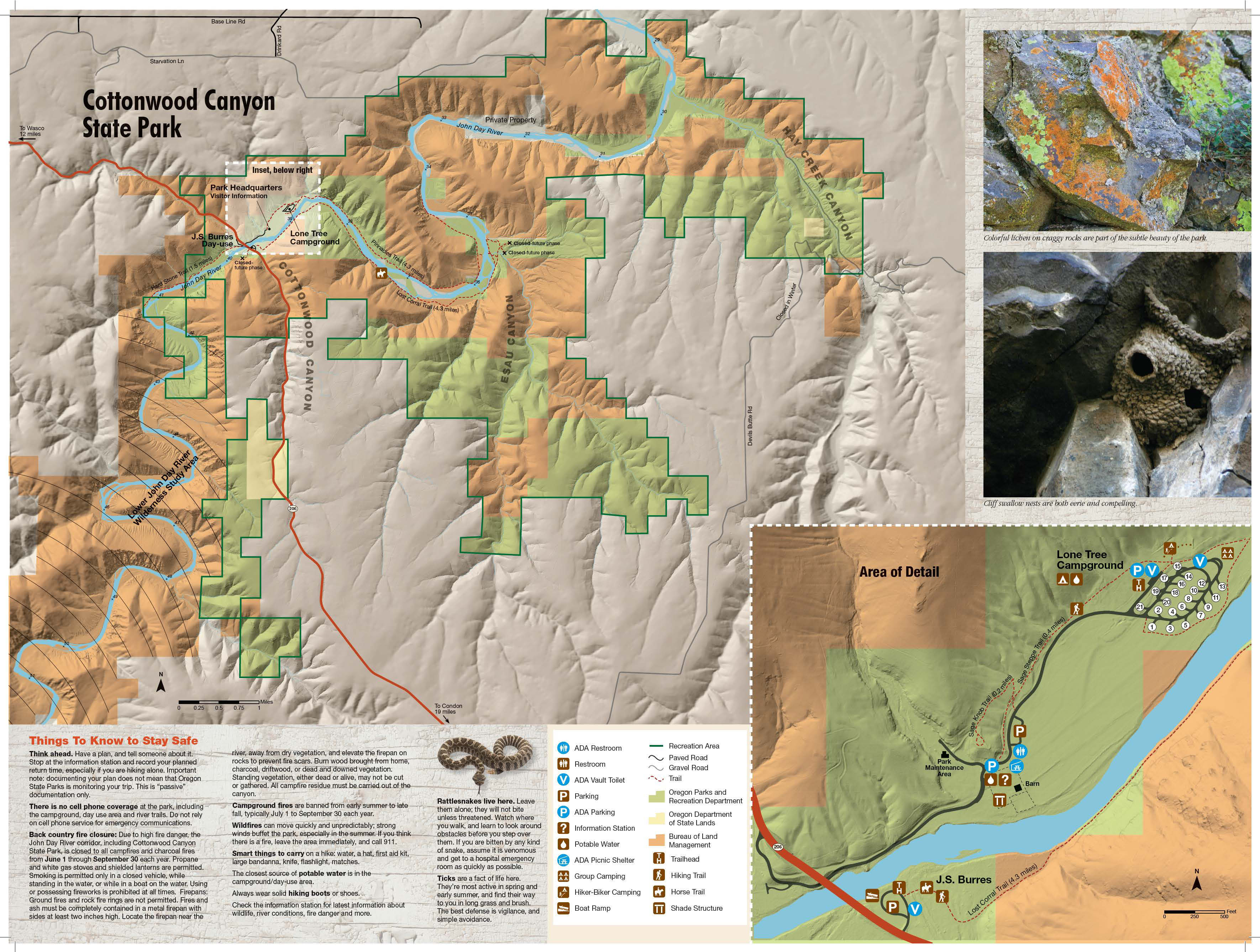
,_Sage_Knob,_Cottonwood_Canyon_S.P..jpg)


- Start point: Murtha Ranch Trailhead

- End point: Murtha Ranch
- Trail Log:
- Hike Type: Loop
- Distance: 1.9 miles
- High point: 620 feet
- Elevation gain: 100 feet
- Difficulty: Easy
- Seasons: All year
- Family Friendly: Yes
- Backpackable: No
- Crowded: No
|
|
Contents |
Hike Description
The Murtha family ran cattle in the hills along this section of the John Day River for generations, and flats along the John Day, Oregon's longest undammed river, were cultivated. The 8,000 acre Murtha Ranch was purchased by the Western Rivers Conservancy in 2008, who then sold it, in a process that was initiated in 2009, to Oregon State Parks to begin the formation of Cottonwood Canyon State Park. The conservancy's objective was to ensure the protection of grassland bird, mammal, and reptile species as well as keep the waters of the John Day pristine. This short loop hike takes you to a viewpoint and then around a former cultivated area and back to the remaining ranch buildings. There's also a welcome center and covered picnic area as well as some rusting farm equipment. In the main ranch complex, now the day-use area for Cottonwood Canyon State Park, you can follow interpretive signs past a barn, corrals, and a windmill.
Cross the paved campground road from the east end of the day-use parking area and find the trail leading up the sagebrush hillside. Go left at a junction and then, 50 yards later, go right at the Sage Knob-Sage Steppe Trail Junction to follow the Sage Knob Trail. Walk up the slope, getting views back to the Murtha Ranch area and the John Day River. Reach a railed platform on Sage Knob with two benches that overlook the ranch barn and park buildings below. A grove of locust trees is just below the lookout and a plum tree flowers profusely here in the spring.
Return down the slope and go left on the Sage Steppe Trail. Hike along the base of the hillside looking down on a wide irrigated field. In 2018, construction was under way here to erect an Experience Center, camping cabins, and a restroom with showers. Near a parking area and restrooms, take a gravel trail which leads below a hiker/biker camp on your left. Pass along the edge of the Lone Tree Campground and reach a kiosk which displays a map, information about invasive puncture vine, and a trail register. This is the Pinnacles-Willow Flats Trail Junction. There's a bench and a large net leaf hackberry on the other side of the fence as the Pinnacles Trail continues from here. To complete the short loop, however, make a right before passing through the gate.
This trail, the Willow Flats Trail, heads towards the John Day River then runs close to it heading southwest. To your right are former agricultural fields of the Murtha Ranch, once planted with crops like alfalfa. Now, camping cabins will take up part of this expanse. Across the river, you'll see sagebrush slopes and a flat crossed by the Lost Corral Trail. Pass spurs that lead to the Lone Tree Campground and left to the river. You'll wander by a lone hackberry, and then it's another 550 yards or so along the verge of the fields until you reach the Murtha Ranch buildings.
There's river access to your left and then a trail that leads right towards the barn. You’ll see a rusting old harvester, geological information, and poetry and stories of settlers and Indians on the plank fencing. Go left to examine the barn, windmill, and information center before returning to your car.
Maps
- Maps: Hike Finder
- Cottonwood Canyon State Park (Oregon State Parks)
- Bureau of Land Management, Fish & Wildlife Service, National Park Service, USDA Forest Service: Lower Deschutes & John Day Rivers
Regulations, facilities, etc
- Dogs on leash
- Restrooms, picnic area, campground, visitor center, interpretive signs
- Day-use hours: 7:00 a.m. - 8:00 p.m.
Trip Reports
- Search Trip Reports for Murtha Ranch Loop Hike
Related Discussions / Q&A
- Search Trail Q&A for Murtha Ranch Loop Hike
Guidebooks that cover this hike
- Oregon State Parks: A Complete Recreation Guide by Jan Bannan
More Links
- Cottonwood Canyon State Park (Oregon State Parks)
- Cottonwood Canyon State Park (Oregon State Parks)
- Cottonwood Canyon State Park (Oregon.gov)
- Cottonwood Canyon State Park Interpretive Prescription (Oregon.gov)
- Cottonwood Canyon State Park (Wikipedia)
- “Cottonwood Canyon State Park continues adding amenities, even green grass” (Oregon Live)
- “Cottonwood Canyon State Park plans ‘Taste of Oregon’s Old West’” (Oregon Live)
Contributors
- bobcat (creator)