Multnomah Falls Hike
From Oregon Hikers Field Guide
Contents |
Info
- Trailhead: Multnomah Falls Trailhead
- Distance: 2.6 miles round-trip
- Elevation gain: 700'
- Difficulty: Moderate, Good trail, but quite a bit of climbing
- Seasons: Year-round
- Family Friendly: Yes
- Backpackable: No
- Crowded: Very
Trip Reports
Hike Description
The trail begins at Multnomah Falls Lodge, a historic building built to serve early automobile travelers in 1925. In 1981, the Multnomah Falls Lodge and Footpath were listed on the National Register of Historic Places. There is a restaurant, gift shop and tourist center inside the lodge, as well as public restrooms. Northwest stereotypes aside, this is probably the only northwest trailhead with a coffee stand. In December 2006, the lodge is getting a new roof, so watch for scaffolding.
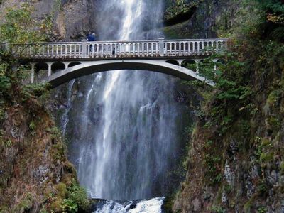
The first part of the trail is a gently sloped 2/10 mile trail to the Benson Bridge, built in 1914 by Simon Benson, one of the builders of the old highway. The bridge is probably the most photographed piece of architecture in Oregon. This part of the trail is a paved cakewalk, although one small flight of a few stairs block the way to wheelchairs beyond the lower falls viewpoint.
Beyond the bridge, the asphalt trail switches up steeply for another mile to a ridgecrest. Look for Columbia River views as you ascend. From the top, the trail drops slightly to a junction with a trail labeled "Top of the Falls Trail #441A" on some old Forest Service documents. Today's signs just say "viewpoint". The asphalt follows the side path to the Multnomah Falls Upper Viewpoint, a balcony of sorts at the lip of the falls looking down on the lodge and the less motivated people below. Most people take in this view, grab a couple of snapshots and return down the steep hill to that mocha latte thing.
Consider hiking further on the Larch Mountain Trail. Details are listed under the Larch Mountain Hike.
Detailed Information
Maps
Fees, Regulations, etc.
- Nothing required at Multnomah Falls Lodge
- Northwest Trail Pass required at Larch Mountain Trailhead
Related Discussions / Q&A
- (Click here to ask a question or start a conversation)
Guidebooks that cover this hike
- Hiking the Columbia River Gorge - 1st and 2nd Editions, by Russ Scheider
- 35 Hiking Trails, Columbia River Gorge, by Don & Roberta Lowe
- Columbia River Gorge, 42 Scenic Hikes, by Don & Roberta Lowe
- Afoot and Afield Portland/Vancouver, by Douglas Lorain
More Links
- See more information at Trails Club of Oregon
- Multnomah Falls Lodge
- HWHiker.com Hike #14
Contributors
- Stevefromdodge (creator)


