Mount Tabor Hike
From Oregon Hikers Field Guide
- Start point: Lincoln Street Trailhead
- End point: Mount Tabor Summit
- Trail Log: Trail Log
- Hike Type: Loop
- Distance: 2.0 miles round trip
- Elevation gain: 350 feet
- Difficulty: Easy
- Seasons: All
- Family Friendly: Yes
- Backpackable: No
- Crowded: Sometimes
Contents |
Hike Description
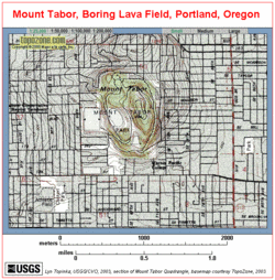
Mount Tabor is an extinct volcano, one of many that dot the landscape east of Portland and make up a complex called the Boring Lava Fields. The mountain is the center of a city park of the same name designed by the Olmsteds. There are many routes you can take in this park. The one described here is a loop that gives the maximum elevation gain and distance, with varied scenery. Some points on this route are marked with posts painted with blue arrows.
Begin on the west side of the park, on 60th Avenue. Hike up the stairs near Hawthorn and 60th to the lowest of the three reservoirs in the park. Turn right to circle south around the reservoir. These reservoirs are the source of Portland's drinking water. The water is piped down from the Bull Run Watershed on the western flanks of Mount Hood.
When you reach the west side of the reservoir, take the stairs that will lead up to the next oval shaped reservoir. Turn right on the access road and look for a trail heading up uphill on your left. This trail goes over a small hill and drops down again above the third and oldest reservoir in the park. Cross the access road on the trail to continue to the summit. This side of the park provides a natural wooded setting amongst huge Douglas-firs. Unfortunately, English ivy and blackberry bushes have invaded the understory. Soon you will reach a five trail junction. In the center is a charming old streetlight with a mossy patina. Turn left here to reach the summit.
A circular drive surrounds the mountain top, but it is closed to motorized traffic. Up here you will just find cyclists, trail-runners and dog-walkers enjoying the summit. Birders with binoculars are often out scouting for the hundreds of species found in the park. From the statue of Mr. Scott, traverse northerly across the grassy hilltop amongst towering Douglas-fir trees. When you reach a bench near a large multi-trunked bigleaf maple, stop for a view of Mt. Hood to the east. Continue downhill northerly past the playground to visit the crater, which is now home to an amphitheater and a basketball court. Turn west from the basketball court and look for the blue signposts to find Skunk Canyon, filled with salmonberry and small cedar trees. At the bottom of the canyon trail, follow the signposts across the access road, and past the tennis court to return to the lower reservoir and 60th Avenue.
Maps
- Maps: Hike Finder
Regulations or Restrictions, etc.
- Dogs must be on leash in this park.
- The park roads are gated to all motorized traffic on Wednesdays.
Trip Reports
- Search Trip Reports for Mt Tabor
Related Discussions / Q&A
- Search Trail Q&A for Mt Tabor
Guidebooks that cover this hike
- Hiking Oregon's Geology by Ellen Morris Bishop
More Links
Contributors
- CFM (creator)


