

Mark O. Hatfield Trail Hike
From Oregon Hikers Field Guide


- Start point: Multnomah Falls Trailhead

- Ending Point: Starvation Creek Trailhead
- Mid-Point Access: Larch Mountain Trailhead
- Mid-Point Access: Wahtum Lake Trailhead
- Mid-Point Access: Rainy Lake Trailhead
- Trail Log: Trail Log
- Distance: 60.0 miles
- Elevation gain: 13,500 feet
- High Point: 4,935 feet
- Difficulty: Difficult
- Seasons: Summer and early Fall
- Family Friendly: No
- Backpackable: Yes
- Crowded: Only near Multnomah Falls
Contents |
Description
NOTICE: Most trails on the Oregon side of the Columbia River Gorge are closed until further notice because of damage from the Eagle Creek Fire. The closure involves ALL trails between Rooster Rock State Park and Hood River. It is anticipated that most of these trails may not reopen until Spring or Summer 2018. Please check the list of Columbia Gorge trail closures before you plan for a hike.
One of the legacies of former Oregon Senator Mark O. Hatfield was expansion of the state’s wilderness system in 1978 and 1984, the largest expansion before or since that time. Though Hatfield was criticized by conservationists for also sponsoring pro-logging legislation that led to the destruction of ancient forests, his role in creating new wilderness in Oregon remains a singular achievement that no other senator has yet matched.
To honor the senator, Congress renamed one of these new wilderness areas, the former Columbia Wilderness, as the Mark O. Hatfield Wilderness in 1996. This recognition marked the senator’s retirement from Congress after nearly a half century of public service that included serving as an Oregon legislator, Oregon’s Secretary of State, then Governor, before finally being elected to the U.S. Senate in 1967, where he served for 30 years. For many, it was also a fitting tribute to the senator who had also pushed through the Columbia River Gorge Scenic Act through Congress in the 1980s.
The Mark O. Hatfield Wilderness originally spanned the most remote high country on the Oregon side of the Columbia River Gorge, but in 2009, President Obama signed a new wilderness bill into law that expanded the Hatfield wilderness significantly. The new boundary stretches the Hatfield Wilderness from Larch Mountain and Multnomah Creek on the west to the steep ridges and canyons of Mount Defiance, on the east. The Mark O. Hatfield Memorial Trail spans the Hatfield Wilderness, beginning at Multnomah Falls and culminating at Starvation Creek Falls, and passing through the most rugged, lonely country to be found in the Columbia River Gorge along the way.
The 60-mile route is described here as a five-night trek, beginning at the Multnomah Falls Lodge, and then leaving civilization behind for most of the next six days as the route traverses through the rugged high country of the Hatfield Wilderness. The following trip log shows the most prominent landmarks along the trail, with proposed camp spots for five nights on the trail. The up-and-down elevation changes inherent to the Hatfield Wilderness terrain will make this a challenging trek for any hiker. Segment and cumulative mileage is shown, along with net elevation gains and losses:
| Destination | Mileage Log | Mileage Total | Elevation +/- | Campsite |
|---|---|---|---|---|
| Multnomah Falls Lodge | 0.0 | 0.0 | 0 | |
| Larch Mountain | 6.5 | 6.5 | 4,010' Gain | • |
| Bell Creek Camp | 4.0 | 10.5 | 1,350’ Loss | • |
| Nesmith Point | 4.6 | 15.1 | 1,160’ Gain | |
| Tanner Creek | 4.6 | 19.7 | 2,510’ Loss | • |
| Dublin Lake | 3.6 | 23.3 | 2,380’ Gain | • |
| Tanner Butte | 3.4 | 26.7 | 980’ Gain | |
| Eagle Creek Camp | 5.1 | 31.8 | 2,900’ Loss | • |
| Indian Springs | 4.8 | 36.6 | 2,600’ Gain | • |
| Wahtum Lake | 4.3 | 41.9 | 550’ Loss | • |
| Herman Creek Camp | 4.0 | 44.9 | 850’ Loss | • |
| Green Point Mtn | 3.0 | 47.9 | 1,865’ Gain | |
| North Lake | 2.4 | 50.3 | 750’ Loss | • |
| Mount Defiance | 2.4 | 52.9 | 780’ Gain | |
| Warren Lake Camp | 1.5 | 54.4 | 1,150’ Loss | • |
| Starvation Creek | 5.6 | 60.0 | 3,625’ Loss | |
| Hike Total | 60.0 | 13,500' Gain |
Day 1 to Bell Creek: the 60-mile trek would begin along the very popular Larch Mountain Trail, following Multnomah Creek beyond the reach of the throngs at Multnomah Falls, then climbing to historic Sherrard Point on Larch Mountain, another popular tourist destination. From here, the trail leaves the tourists behind, dropping into ancient forests along Bell Creek and the first campsite at 10.5 miles.
Day 2 to Dublin Lake: this is the most strenuous day along the circuit, covering 12.8 miles as the trail climbs over the shoulder of Nesmith Point, drops into Tanner Creek canyon, then climbs out again to arrive at Dublin Lake. At Nesmith Point, hikers can look down on the Columbia River nearly 4,000 feet below from the highest point on the Gorge rim, and on Van Ahn Rim hikers will get a rare look into the backcountry of the Tanner Creek canyon and into the Bull Run Reserve.
Day 3 to Eagle Creek: the third day of the Hatfield Trail is a nearly 2,000 foot drop to Eagle Creek over 8.5 miles, and another bridge-less ford in the middle of the Hatfield Wilderness. This short day allows for the spectacular side trip to Tanner Butte, along the way. If the weather is uncooperative for mountain views, another side-trip option is to head downstream on the Eagle Creek Trail to Twister Falls and Tunnel Falls, a spectacular 4.5 mile side-trip from the Eagle Creek campsite.
(Note that the map shows a proposed 9-mile hike in green along the high ridges of the Eagle Creek backcountry. The proposed new trail segment would begin north of Tanner Butte, and traverses across the rugged talus slopes and mountain tarns of Eagle Butte and Table Mountain, with expansive views into the Eagle Creek canyon, 3,000 feet below. This is still just a concept, but part of the long-term vision for the Hatfield Trail).
Day 4 to Herman Creek: on the fourth day, the route climbs steadily from Eagle Creek to the open meadows of Indian Mountain, where it joins the Pacific Crest Trail and Indian Springs camp, then heads east to popular Wahtum Lake. The lake provides a midpoint trailhead access for those looking for a shorter trip, an alternative camping spot or possibly a feed drop for those planning stock trips along the trail. From Wahtum Lake, the trail climbs over Anthill Ridge, then descends past Mud Lake before reaching a campsite at Herman Creek at the 12.1 miles.
Day 5 to Warren Lake: this is also a less demanding day, with most of the climbing in the first few miles, as the route climbs out of the Herman Creek canyon, and passes the rocky summit of Green Point Mountain, with expansive views of the surrounding wilderness. From here, the route passes above Rainy, North and Bear lakes before curving around the rocky north face of Mount Defiance, then dropping to beautiful Warren Lake at 9.5 miles.
Note: while the recommended circuit includes a night at Warren Lake to enjoy the exceptionally rugged setting and wilderness scenery, the relatively short, final leg to Starvation Creek will draw many hikers to make this a 5-day trip, and skip the final campsite at Warren Lake. For these hikers, the lake might simply offer the opportunity for a quick swim before heading back to civilization.
Day 6 to Starvation Creek: the short, 5.6 mile final leg travels steeply down the north slope of Mount Defiance along Starvation Ridge, dropping 3,600 feet in just over five miles. Along the way, the trail passes above dizzying cliff-top viewpoints and shady side-canyon waterfalls before reaching the Columbia River and the end of the trail at Starvation Creek.
The restrooms, telephone, easy highway access and shady, un-crowded streamside picnic sites below lofty Starvation Creek Falls make this an ideal terminus for hikers seeking to relax after their adventure. The following table summarizes the recommended 6-day hike, with running mileage and daily elevation gains:
| Destination | Day Total | Trip Total | Elevation +/- |
|---|---|---|---|
| Begin: Multnomah Falls Lodge | 0.0 | 0.0 | 0 |
| Night 1: Bell Creek Camp | 10.5 | 10.5 | 4,010' Gain |
| Night 2: Dublin Lake Camp | 12.8 | 23.3 | 3,540 Gain |
| Night 3: Eagle Creek Camp | 8.5 | 31.8 | 1,900’ Loss |
| Night 4: Herman Creek Camp | 12.1 | 44.9 | 1,295’ Gain |
| Night 5: Warren Lake Camp | 9.5 | 54.4 | 2645’ Gain |
| End: Starvation Creek State Park | 5.6 | 60.0 | 13,500’ Total |
Maps

Trip Reports
- Search Trip Reports for Mark O. Hatfield Trail Hike
(Click here to add your own)
Hatfield Trail - Angels Rest to Starvation Creek (June 2012)
Columbia Gorge Thru Hike (August 2009)
Related Discussions / Q&A
- Search Trail Q&A for Mark O. Hatfield Trail Hike
Ongoing Portland Hikers forum devoted to the Mark O. Hatfield Trail
More Links
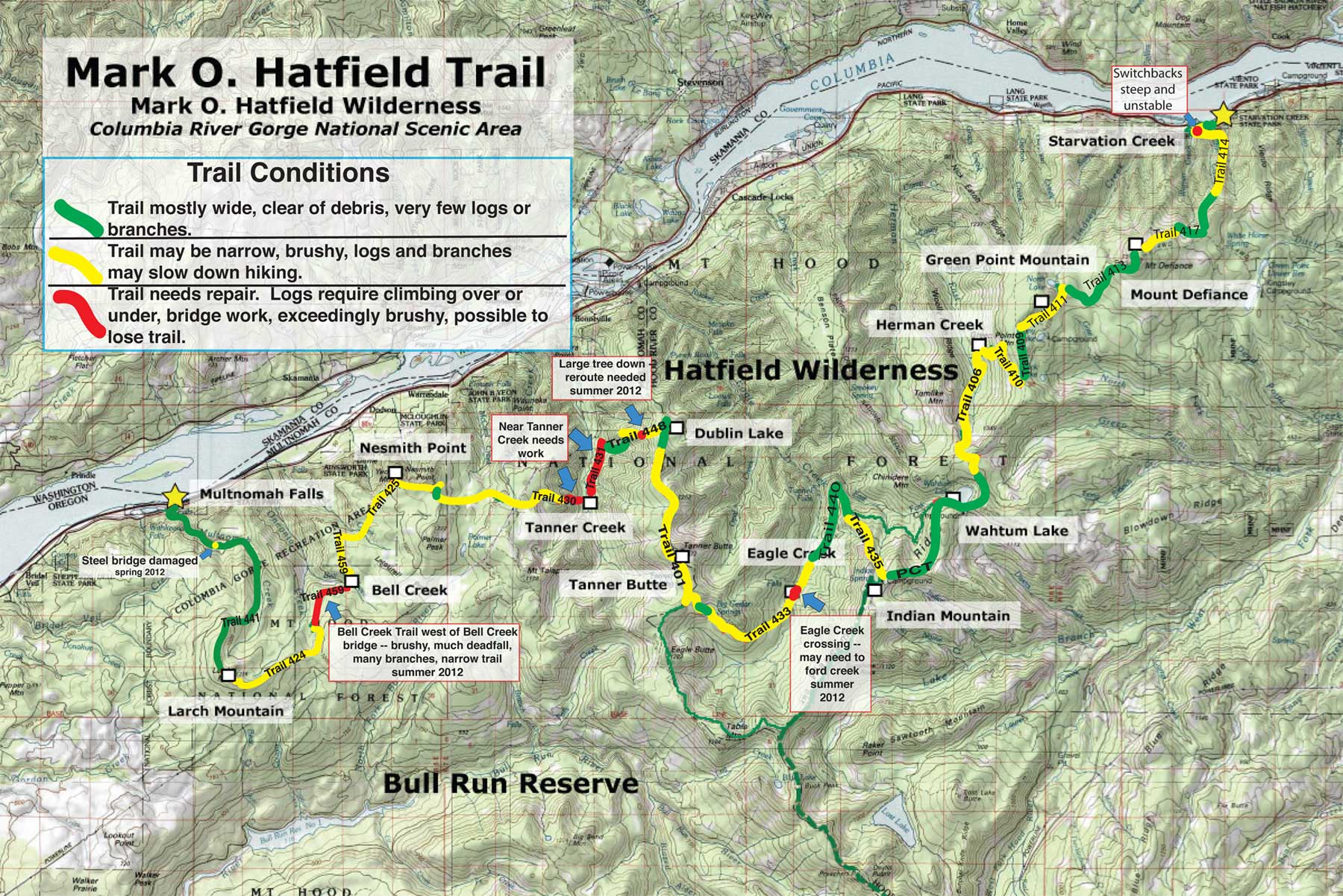
Hatfield Trail section numbers and trail conditions overlay (by Chase, as of July 6, 2012)
Original WyEast Blog Article on the Mark O. Hatfield Trail