

Difference between revisions of "Starvation Ridge Viewpoint Hike"
From Oregon Hikers Field Guide
Splintercat (Talk | contribs) |
Splintercat (Talk | contribs) |
||
| Line 12: | Line 12: | ||
* Trail Log: [[Lower Starvation Loop Hike/Log | Trail Log]] | * Trail Log: [[Lower Starvation Loop Hike/Log | Trail Log]] | ||
* Hike Type: Loop | * Hike Type: Loop | ||
| − | {{Distance| | + | {{Distance|3.0 miles}} |
{{Elevation gain|1,280 feet}} | {{Elevation gain|1,280 feet}} | ||
{{Difficulty|Moderate}} | {{Difficulty|Moderate}} | ||
Revision as of 15:38, 15 October 2012


- Start point: Starvation Creek Trailhead

- End point: Lancaster Falls
- Trail Log: Trail Log
- Hike Type: Loop
- Distance: 3.0 miles
- Elevation gain: 1,280 feet
- Difficulty: Moderate
- Seasons: Year Round
- Family Friendly: No
- Backpackable: No
- Crowded: No
Contents |
Hike Description
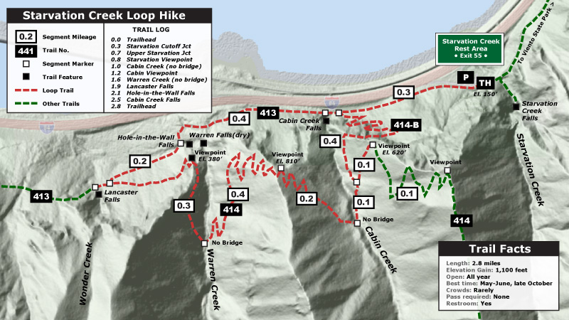
This is a hike for those that haven't the time or the stamina to do Mount Defiance. This gives you a quick sample of what the big hill is like, as well as views and waterfalls. As with most Gorge trails, watch for poison oak in open areas, and especially forest margins - it crowds the trail in several spots, but is easily avoided if you can identify it. This hike is also categorized as not family friendly, due to some sheer drops along the way. Dog enthusiasts should leash their pets for the same reason. A final caveat is that highway noise is noticeable at several points along the way, but the combination of great scenery and interesting features makes it easy to ignore the occasional noise.
From the Starvation Creek Trailhead, start on the Mount Defiance Trail next to the freeway. In about 1/10 of a mile the trail leaves the freeway shoulder and starts down an old section of the original Columbia River Highway. Another 1/10 mile brings you to a junction with the Starvation Cutoff Trail #414B. Turn left here and head up the hill. There are a lot of comments to be made about various trails, but this little bugger is just brutal. It's safe enough and fortunately it's only 4/10 of a mile long. The real problem is that only 3 of those tenths are sideways, the other one is straight up. The trail switchbacks through the trees gaining a foot in elevation every stride. It's best to just buckle down and deal with it, and going up this trail is infinitely easier than going down it - and therefore the direction described here. The rest of the hike is a cakewalk once you've covered this section.
At the top, you'll find a junction with the Starvation Ridge Trail #414. The main route heads right, to a pleasant crossing of Cabin Creek. But take a moment to head left for 150 yards, to a stunning overlook, just off the trail at the next switchback. From this airy perch, you will be able to look down and see your car, and have broad vistas up and down the Gorge. After taking in the view, retrace your steps back to the junction, and continue on toward Cabin Creek. You've got a tiny bit of better graded climbing beyond Cabin Creek, but you're rewarded with a [[Starvation Ridge First Viewpoint|another beautiful viewpoint of the Columbia River Gorge, just off the trail after you've passed under the powerlines. There's lots of room, but stay back from the edge. A fall from here would be fatal.
Continuing on, the trail begins a gentle descent through meadows that bloom like crazy in the spring. Look for Indian Paintbrush, Chocolate Lilies, Shooting Star, Glacier Lily, Buttercups and Rosy Plectritis here. If your lucky, you might spot eagles or ospreys flying in the area, as well. The trail drops elevation pretty steadily to the Warren Creek Crossing. In early spring, Warren Creek is big enough that a bridge would be nice, but you'll have to make due with a log and rock hop, so use care. When you crest the next little point beyond the creek, look up to a power line tower on the ridge for a large osprey nest. The trail continues down to another trail junction, this time with the Mount Defiance Trail.
Turn left here and head up the Mount Defiance Trail a short distance to Lancaster Falls. The lower tier splashes almost directly on to the trail, but the best views up the upper tier are only visible by scrambling. When you're done here, head back the way you came to the last trail junction. Continue down the Mount Defiance Trail toward the trailhead. Soon you'll pass Hole in the Wall Falls and then you'll return to the old highway. Finally, Cabin Creek Falls makes a good place to wind down your day only 3/10 of a mile from your car.
Regulations or restrictions, etc
- None
Trip Reports
- Search Trip Reports for Starvation
Related Discussions / Q&A
- Search Trail Q&A for Starvation
Maps
Splintercat's map of this hike (the loop is described clockwise)
- Maps: Hike Finder
Contributors
- Stevefromdodge (creator)
- Splintercat (Tom Kloster) (contributor)