

Gooseneck Loop Hike
From Oregon Hikers Field Guide

,_Sage_Knob_Ridge,_Cottonwood_Canyon_S.P..jpg)


- Start point: Murtha Ranch Trailhead

- End point: Gooseneck Viewpoint
- Trail Log:
- Hike Type: Loop
- Distance: 10.6 miles
- High point: 1630 feet
- Elevation gain: 1485 feet
- Difficulty: Difficult
- Seasons: All year
- Family Friendly: Yes
- Backpackable: No
- Crowded: No
|
|
Contents |
Hike Description
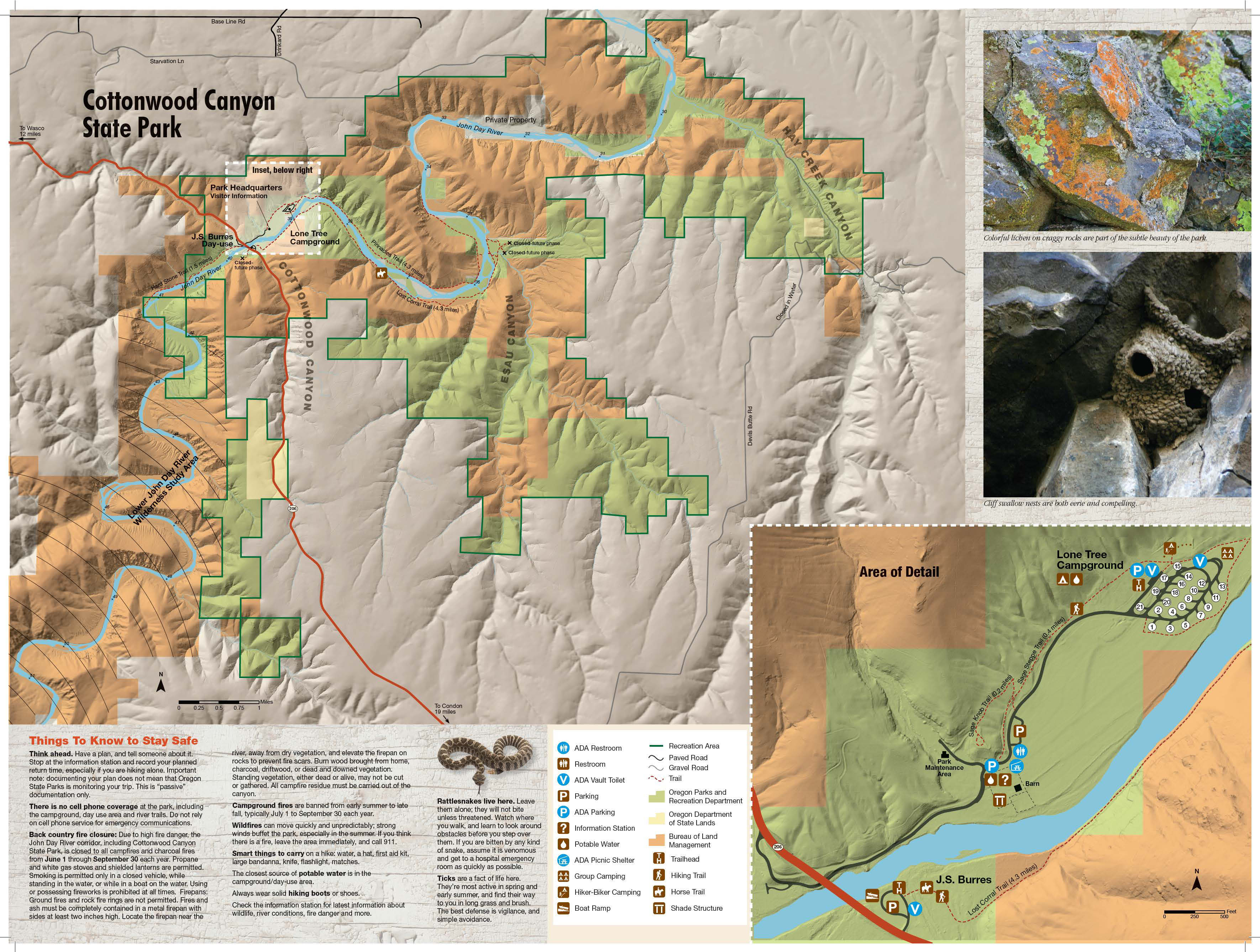
Cottonwood Canyon State Park is one of the newest additions ot Oregon’s much admired state parks system. The park opened in 2013 and immediately became the second-largest in the state (Silver Falls State Park is the largest) at over 8,000 acres. Most of what is now the park was once part of the Murtha Ranch, a property that ran on both sides of the John Day River and encompassed a variety of habitats: river bottoms, canyons, basalt palisades, grassland, and sagebrush steppe. The park also hosts Oregon’s largest herd of California bighorn sheep – around 600 – 650 animals. There is a developed area, with campground, day-use facilities, and an interpretive trail. The loop hike described here includes all of the habitats, but much of the hike is off-trail, some in rough terrain, and requires good route-finding skills.
The destination for this hike is an impressive 1000-foot high ridge, unofficially known as the Gooseneck, around which the John Day makes a big lazy loop. The officially named Gooseneck is similarly structured, but is not nearly as imposing, and lies about 20 river miles to the south.
Cross the campground road from the east end of the day-use parking area, and find the trail leading up the sagebrush slope behind the sign for the Sage Knob and Sage Steppe Trails. Go left at a junction and then, 50 yards later, go right at the Sage Knob-Sage Steppe Trail Junction. Walk up the slope getting views back to the Murtha Ranch area and the John Day River. Reach a railed platform with two benches on Sage Knob that overlooks the ranch barn and park buildings below. A grove of locust trees is just below the lookout and a plum tree flowers profusely here in the spring.
To begin the Gooseneck route, hike under the wood arch behind the viewing area. The scratch of a trail may be marked by faded flagging. Wind up the slope to the ridge crest. Then the path, such as it is, tends to keep to the right side of the crest as it passes below rocky outcrops. Balsamroot and prairie star are the main bloomers here in early spring. The route passes below a rugged outcropping splashed with white raptor droppings and heads left up the slope to eventually reach the grassy knoll of Peak 1443. From this peak, you’ll get more expansive views of the John Day River as well as the agricultural lands of the Columbia Plateau. Powerlines run from south to north and windmills festoon the landscape.
Head to the right down the knoll to a fence line and walk along this fence. Arrive above a steep gully, which you’ll have to descend carefully, picking your way and always keeping close to the fence line. Before dropping too far, train your eyes (or binoculars, if you have them) on the slopes across from you. There may be a large herd of California bighorns resting up there. Descending the slope, you’ll pass a large juniper and then veer away from the fence for an easier line of descent. Reach the trickling stream at the bottom of the gully and find a faint animal trail which will take you up the opposite slope. First, you’ll keep away from the fence to circumvent an outcropping and then head towards it. As you get to the top of the Gooseneck Ridge, views open up and both Mount Adams and Mount Hood can be seen. Drop into a shallow draw and reach the corner of a fence line and a jeep track.
Go right on the jeep track, which leads out along the Gooseneck Ridge. Continue looking back to get views of the mountains, and keep your eyes peeled for bighorn sheep. You’ll see a solar-powered antenna on your right and get good views down to the left of a wide meander in the John Day River. Eventually reach the end of the jeep track and pick up a foot trail that heads long the ridge crest. Get a great view of red cliffs below to your left and back to the park campground on the right. Gold stars and prairie stars bloom among the sagebrush here in spring. Reach a small cairn and spreading juniper at the Gooseneck Viewpoint, a good resting point that offers vistas in all directions. To descend the Gooseneck, continue along the ridge crest and then begin to drop down the slope. You can go left or right, but the former choice will allow you to hike to the end of the Pinnacles Trail. Gradually angle down, always heading north/northwest. The many small seeps here support colonies of saxifrage and shooting stars.
Eventually reach the old farm road at the bottom of the slope: this is the Pinnacles Trail. Go left and hike through tall big-leaf sagebrush and Scotch thistles. The red cliffs loom across the river to your right, and there are high basalt walls ahead. Hike by a gate post, and walk below these cliffs, passing through a stand of poison hemlock. The river bank here is lined with golden currant, netleaf hackberry, and white alder. The track narrows, and you’ll see a basalt pinnacle piercing the sky above. This is a good point to turn around as the trail peters out not far from this point at the Pinnacles Trail End.
Return on the sandy track and begin to round the Gooseneck. Under the basalt ramparts you’ll notice a small bank of wind-rippled sand near a bench. The river braids here around a large willow bar. Low cliffs opposite shade the Lost Corral. To its left is Esau Canyon and, straight ahead, you can get a view of the mouth of Rattlesnake Gulch with its intermittent waterfall. Continue hiking below the grassy slopes of the Gooseneck at this wide bend in the river. Hike below a dry gully, and see basalt fortifications and an exfoliating pinnacle above as you pass through a gate. At the Pinnacles-D and H Trail East Junction, go right to gain a little elevation on a sagebrush slope and better views of the river (The Pinnacles Trail keeps on a sandy tread in the sagebrush below, bypassing a copse of white alder). Long-leaf phlox and woolly-pod milkvetch bloom trailside in the spring, and you can see across to the willow-lined opposite bank of the John Day. Reach a four-way junction at a huge locust tree where the D and H Trail rejoins the Pinnacles Trail: there’s a shoreline option for hikers straight ahead.
Go right here on the road track/trail, and continue under basalt cliffs exhibiting a trickling waterfall. Hackberry trees line the river bank. A user trail leads up a dry gulch on the right, and then the basalt entablature forms an overhang over the trail. Hike through a gate and scan the overhang for the mud nests of cliff swallows. Pass an enclosure in a field and the mouth of the deep gully that you crossed heading to the Gooseneck. Pungent desert parsley and prairie stars bloom in this sagebrush flat. Come to a bench, fence, and kiosk at a large netleaf hackberry, which offers welcome shade in the heat of the day. The kiosk offers a map, information about invasive puncture vine and also has a trail register. This is also the Pinnacles-Willow Flats Trail Junction, the latter trail a loop along the river that leads to the campground and the Murtha Ranch.
Keep right on a gravel trail, which passes the edge of the open campground area. There’s a hiker/biker camp to the right, also very open, before you join the Sage Steppe Trail near a parking area/restrooms. Hike up the slope above the campground and look down on a wide irrigated field. At a junction, go left to cross the campground road and reach the Murtha Ranch Trailhead.
Maps
- Maps: Hike Finder
- Cottonwood Canyon State Park (Oregon State Parks)
- Bureau of Land Management, Fish & Wildlife Service, National Park Service, USDA Forest Service: Lower Deschutes & John Day Rivers
Regulations or restrictions, etc
- Dogs on leash
- Share Pinnacles Trail with cyclists
Trip Reports
- Search Trip Reports for Gooseneck Loop Hike
Related Discussions / Q&A
- Search Trail Q&A for Gooseneck Loop Hike
Guidebooks that cover this hike
- Oregon State Parks: A Complete Recreation Guide by Jan Bannan
More Links
- Cottonwood Canyon State Park (Oregon State Parks)
- Cottonwood Canyon State Park (Oregon State Parks)
- Cottonwood Canyon State Park (Oregon.gov)
- Cottonwood Canyon State Park (Wikipedia)
Contributors
- bobcat (creator)