Difference between revisions of "Cairn Basin from Vista Ridge Hike"
From Oregon Hikers Field Guide
Retiredjerry (Talk | contribs) m |
m (Playing with pic placement) |
||
| Line 5: | Line 5: | ||
[[Image:VistaRidgeHoodSunset.jpg|thumb|400px|Fields of Lupine on Vista Ridge]] | [[Image:VistaRidgeHoodSunset.jpg|thumb|400px|Fields of Lupine on Vista Ridge]] | ||
| − | |||
| − | |||
| − | |||
== Info == | == Info == | ||
| Line 20: | Line 17: | ||
* Crowded: Summer weekends | * Crowded: Summer weekends | ||
== Description == | == Description == | ||
| − | This hike combines visits to three of Mount Hood’s alpine “parks”: idyllic Eden Park, rugged Cairn Basin and starkly beautiful WyEast Basin. Each was named by a Mazama Club expedition in the early 1900s, helping lead to the construction of the Timberline Trail. The scenery on this loop is some of the finest on the mountain, with lush wildflower displays in July and early August. | + | [[Image:VistaRidgeCreek.jpg|250px|thumb|Wildflower Swale near Cairn Basin|left]] |
| + | This hike combines visits to three of Mount Hood’s alpine “parks”: idyllic Eden Park, rugged Cairn Basin and starkly beautiful WyEast Basin. Each was named by a Mazama Club expedition in the early 1900s, helping lead to the construction of the Timberline Trail. The scenery on this loop is some of the finest on the mountain, with lush [[Image:VistaRidgeSunset.jpg|250px|thumb|Summer Sunset from Vista Ridge]] | ||
| + | wildflower displays in July and early August. | ||
From the [[Vista Ridge Trailhead]], the route intitially follows a rocky, overgrown roadbed before entering deep forest and a softer trail surface. At 0.2 miles, reach a trail junction and turn right (uphill) onto the Vista Ridge trail. Follow this evenly graded route as it climbs through forest for 2.5 miles to the Timberline Trail junction, and the first of many fine views of Mount Hood. Turn left here, following the sign Eden Park. The trail drops from Vista Ridge, soon passing several steep meadows with views that include Lost Lake, nestled in the forest below. After passing a pair of flower-lined swales, reach rushing Ladd Creek. Like most glacial streams within the Mount Hood Wilderness, the crossing is bridgeless, and can require some ingenuity. After crossing, look for the resumption of the trail a bit further downstream, and after a brief walk through open forest, reach the north end of Eden Park at 3.7 miles, with picturesque views of Mount Hood towering over the meadow. | From the [[Vista Ridge Trailhead]], the route intitially follows a rocky, overgrown roadbed before entering deep forest and a softer trail surface. At 0.2 miles, reach a trail junction and turn right (uphill) onto the Vista Ridge trail. Follow this evenly graded route as it climbs through forest for 2.5 miles to the Timberline Trail junction, and the first of many fine views of Mount Hood. Turn left here, following the sign Eden Park. The trail drops from Vista Ridge, soon passing several steep meadows with views that include Lost Lake, nestled in the forest below. After passing a pair of flower-lined swales, reach rushing Ladd Creek. Like most glacial streams within the Mount Hood Wilderness, the crossing is bridgeless, and can require some ingenuity. After crossing, look for the resumption of the trail a bit further downstream, and after a brief walk through open forest, reach the north end of Eden Park at 3.7 miles, with picturesque views of Mount Hood towering over the meadow. | ||
| Line 30: | Line 29: | ||
After taking in the view, follow the Timberline Trail a short distance to a 3-way trail junction, just west of WyEast Basin. Take a moment to go right for a few yards to a nice view of the basin at 5.4 miles. | After taking in the view, follow the Timberline Trail a short distance to a 3-way trail junction, just west of WyEast Basin. Take a moment to go right for a few yards to a nice view of the basin at 5.4 miles. | ||
| + | [[Image:EdenParkRidgeView.jpg|250px|thumb|Eden Park from below Cairn Basin|left]] | ||
If you're not tired yet, there's a faint, unmarked trail going up from WyEast Basin, to Barret Spur, in about a mile, to about 7700'. Look back occasionally so you can find your way back. There are excellent views to the North and West, and close-up views of Mount Hood glaciers. | If you're not tired yet, there's a faint, unmarked trail going up from WyEast Basin, to Barret Spur, in about a mile, to about 7700'. Look back occasionally so you can find your way back. There are excellent views to the North and West, and close-up views of Mount Hood glaciers. | ||
Return back to the Vista Ridge Trail following the sign pointing to Eden Park. From here, the route passes through a rugged swale that traces the east foot of Vista Ridge, then drops to the Vista Ridge Trail junction at the 5.7 mile mark. Turn right, and follow your original path the remaining 2.7 miles to your car. | Return back to the Vista Ridge Trail following the sign pointing to Eden Park. From here, the route passes through a rugged swale that traces the east foot of Vista Ridge, then drops to the Vista Ridge Trail junction at the 5.7 mile mark. Turn right, and follow your original path the remaining 2.7 miles to your car. | ||
| + | {{-}} | ||
== Trip Reports == | == Trip Reports == | ||
(Click [http://portlandhikers.com/forums/AddPost.aspx?ForumID=8 here] to add your own) | (Click [http://portlandhikers.com/forums/AddPost.aspx?ForumID=8 here] to add your own) | ||
Revision as of 06:21, 5 January 2007
Contents |
Info
- Trailhead: Vista Ridge Trailhead
- Distance: 8.4 miles round-trip
- Elevation Gain: 1,560 feet
- High Point: 5,920 feet
- Difficulty: Difficult, due to Ladd Creek Crossing
- Seasons: Summer and early Fall
- Family Friendly: Yes, for older kids
- Backpackable: Yes - follows the Timberline Trail
- Crowded: Summer weekends
Description
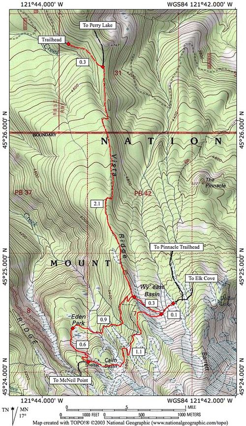
This hike combines visits to three of Mount Hood’s alpine “parks”: idyllic Eden Park, rugged Cairn Basin and starkly beautiful WyEast Basin. Each was named by a Mazama Club expedition in the early 1900s, helping lead to the construction of the Timberline Trail. The scenery on this loop is some of the finest on the mountain, with lushwildflower displays in July and early August.
From the Vista Ridge Trailhead, the route intitially follows a rocky, overgrown roadbed before entering deep forest and a softer trail surface. At 0.2 miles, reach a trail junction and turn right (uphill) onto the Vista Ridge trail. Follow this evenly graded route as it climbs through forest for 2.5 miles to the Timberline Trail junction, and the first of many fine views of Mount Hood. Turn left here, following the sign Eden Park. The trail drops from Vista Ridge, soon passing several steep meadows with views that include Lost Lake, nestled in the forest below. After passing a pair of flower-lined swales, reach rushing Ladd Creek. Like most glacial streams within the Mount Hood Wilderness, the crossing is bridgeless, and can require some ingenuity. After crossing, look for the resumption of the trail a bit further downstream, and after a brief walk through open forest, reach the north end of Eden Park at 3.7 miles, with picturesque views of Mount Hood towering over the meadow.
From Eden Park, the trail climbs an open slope for a half-mile in a series of short switchbacks before reaching Cairn Basin at 4.2 miles, with its stone shelter and handsome, wildflower-framed mountain views. The trail is lined with rocks through the heavily used camping area adjacent to the meadow to help you follow the route. Continue straight where an informal trail heads to the stone shelter on the right, and soon reach a second crossing of Ladd Creek.
From Ladd Creek, the route climbs through a pair of switchbacks before traversing through still more steep meadows and a high, rocky swale that provides a fine view of the mountain. Soon the route rounds Vista Ridge, and reaches an excellent viewpoint at 5.2 miles that includes Hood, Adams and Rainier, as well as farms in the Upper Hood River Valley, and the entire Vista Ridge route, far below.
After taking in the view, follow the Timberline Trail a short distance to a 3-way trail junction, just west of WyEast Basin. Take a moment to go right for a few yards to a nice view of the basin at 5.4 miles.
If you're not tired yet, there's a faint, unmarked trail going up from WyEast Basin, to Barret Spur, in about a mile, to about 7700'. Look back occasionally so you can find your way back. There are excellent views to the North and West, and close-up views of Mount Hood glaciers.
Return back to the Vista Ridge Trail following the sign pointing to Eden Park. From here, the route passes through a rugged swale that traces the east foot of Vista Ridge, then drops to the Vista Ridge Trail junction at the 5.7 mile mark. Turn right, and follow your original path the remaining 2.7 miles to your car.
Trip Reports
(Click here to add your own)
Active Conversations / Q&A
(Click here to ask a question or start a conversation)
Maps
More Links
Page Contributors
- Splintercat (Tom Kloster) (primary)
- User:retiredjerry


