

Difference between revisions of "Aldrich Butte-Cedar Falls Loop Hike"
From Oregon Hikers Field Guide
(Add content) |
(Reorder categories) |
||
| (14 intermediate revisions by one user not shown) | |||
| Line 1: | Line 1: | ||
| − | [[Category: | + | {{Lost Hike}} |
| + | [[Category:Southwest Washington]] | ||
[[Category:Columbia River Gorge]] | [[Category:Columbia River Gorge]] | ||
| + | [[Category:All Season Hikes]] | ||
[[Category:Creek Hikes]] | [[Category:Creek Hikes]] | ||
[[Category:Hot Spring Hikes]] | [[Category:Hot Spring Hikes]] | ||
[[Category:Difficult Hikes]] | [[Category:Difficult Hikes]] | ||
[[Category:Off The Beaten Track]] | [[Category:Off The Beaten Track]] | ||
| − | |||
[[Category:Unmaintained Trails]] | [[Category:Unmaintained Trails]] | ||
[[Category:Viewpoint Hikes]] | [[Category:Viewpoint Hikes]] | ||
[[Category:Waterfall Hikes]] | [[Category:Waterfall Hikes]] | ||
[[Category:Hikes]] | [[Category:Hikes]] | ||
| − | |||
| − | [[Image: | + | [[Image:Cedar Creek at the winter crossing.jpg|thumb|400px|Cedar Creek at the winter crossing ''(bobcat)'']] |
| − | [[Image: | + | [[Image:Gillette Lake, Bonneville Slide.jpg|thumb|250px|Gillette Lake and Hamilton Mountain ''(bobcat)'']] |
[[Image:CedarMountain04.jpg|thumb|250px|Cedar Mountain and Table Mountain from Aldrich Butte ''(Jeff Statt)'']] | [[Image:CedarMountain04.jpg|thumb|250px|Cedar Mountain and Table Mountain from Aldrich Butte ''(Jeff Statt)'']] | ||
| − | |||
[[Image:BonnevilleFromAldrich.jpg|thumb|250px|The Bonneville area from the top of Aldrich Butte ''(Jeff Statt)'']] | [[Image:BonnevilleFromAldrich.jpg|thumb|250px|The Bonneville area from the top of Aldrich Butte ''(Jeff Statt)'']] | ||
| + | [[Image:Looking down Hamilton Creek from the big slide.jpg|thumb|250px|Looking down Hamilton Creek from the big slide ''(bobcat)'']] | ||
| + | [[Image:CedarFalls.jpg|thumb|160px|Cedar Falls ''(Jeff Statt)'']] | ||
| + | [[Image:AldrichButteCedarFallsMap.png|thumb|500px|The route to the Cedar Falls area (not a GPS track) ''(bobcat)'' Courtesy: ''Caltopo'']] | ||
{{Start point|Bonneville Trailhead}} | {{Start point|Bonneville Trailhead}} | ||
* End point: [[Hamilton Creek Viewpoint]] | * End point: [[Hamilton Creek Viewpoint]] | ||
| − | * Trail Log: | + | * Trail Log: |
* Hike Type: Lollipop loop | * Hike Type: Lollipop loop | ||
{{Distance|16.4 miles}} round trip | {{Distance|16.4 miles}} round trip | ||
| Line 33: | Line 35: | ||
=== Hike Description === | === Hike Description === | ||
| − | The hike in to [[Aldrich Butte]] and [[Cedar Falls]] covers a little known section of the Gorge between [[Table Mountain]] and [[Hamilton Mountain]] near the town of North Bonneville, Washington. This may not be the grandest of excursions in the [[Columbia River Gorge]], but it is certainly one of the quietest. For those who really value solitude, this is something of an unknown gem in an area with a lot of interesting history. It's a long hike in here now, after the closure of the Bonneville Hot Springs Resort & Spa in January 2017 and the termination of the resort's agreement to allow a public trailhead on their land (the former Dick Thomas Trailhead). The only legitimate approach is from the [[Bonneville Trailhead]], a long and meandering walk over the forested terrain of the Bonneville Landslide, much of it a Pacific Crest Trail easement on private land. You will be rewarded at the end of your hike, however, with a little-visited landscape of secluded creeks, an isolated waterfall, and the vestiges of the military emplacements atop [[Aldrich Butte]]. Note that trail junctions off the PCT are usually not marked, so pay close attention to the directions. | + | The hike in to [[Aldrich Butte]] and [[Cedar Falls]] covers a little known section of the Gorge between [[Table Mountain]] and [[Hamilton Mountain]] near the town of North Bonneville, Washington. This may not be the grandest of excursions in the [[Columbia River Gorge]], but it is certainly one of the quietest. For those who really value solitude, this is something of an unknown gem in an area with a lot of interesting history. It's a long hike in here now, after the closure of the Bonneville Hot Springs Resort & Spa in January 2017 and the termination of the resort's agreement to allow a public trailhead on their land (the former Dick Thomas Trailhead). The only legitimate approach is from the [[Bonneville Trailhead]], a long and meandering walk over the forested terrain of the Bonneville Landslide, much of it a Pacific Crest Trail easement on private land. You will be rewarded at the end of your hike, however, with a little-visited landscape of secluded creeks, an isolated waterfall, and the vestiges of the military emplacements atop [[Aldrich Butte]]. Note that trail junctions off the PCT in the [[Carpenters Lake]]-[[Aldrich Butte]]-[[Cedar Falls]] area are usually not marked, so pay close attention to the directions and remain oriented at all times. |
| + | |||
| + | Note that Foundations Recovery Network, the new owners of the former Bonneville Hot Springs Resort & Spa, are sensitive to the recent and sudden decommissioning of the Dick Thomas Trailhead and are partnering with Bonneville Trails Foundation to develop closer trailhead access. However, those options are not available for the short term, so the [[Bonneville Trailhead]] is the only option for now. | ||
| − | The hike starts at the [[Bonneville Trailhead]], on the Tamanous Trail. Ta-mah-no-ous is a Native American word translated roughly as "vision quest". Young men proved their readiness to be adults by going on a search for guardian spirits. From the parking lot, you start out on a gravel road, but quickly divert up a wooded path that starts straight uphill | + | The hike starts at the [[Bonneville Trailhead]], on the Tamanous Trail. Ta-mah-no-ous is a Native American word translated roughly as "vision quest". Young men proved their readiness to be adults by going on a search for guardian spirits. From the parking lot, you start out on a gravel road, but quickly divert up a wooded path that starts straight uphill (Incidentally, if you continue down the gravel road another 100 yards, you'll see where the nearby train track enters a tunnel). It won't be long before you have a nice viewpoint to the south overlooking the river just east of the [[Bonneville Dam]]. There won't be much more in the way of views for a while. It is somewhere in this trail section where the route crosses over the top of the aforementioned tunnel...but you'll be hard-pressed to see where! |
After a little more than half a mile from the trailhead, you'll come to a junction with the [[Pacific Crest-Tamanous Trail Junction|Pacific Crest Trail]]. Turn left and you'll be heading toward Canada (even if you are heading more west than north). There are two ponds near this junction, both unnamed - the first is seasonal and you may not notice it during the warmer months; the other is farther up the trail just an 1/8 of a mile or so: watch downhill and you'll see it between the trees. Follow the trail closely in this section, and do not divert onto the overgrown forest roads that intertwine here. | After a little more than half a mile from the trailhead, you'll come to a junction with the [[Pacific Crest-Tamanous Trail Junction|Pacific Crest Trail]]. Turn left and you'll be heading toward Canada (even if you are heading more west than north). There are two ponds near this junction, both unnamed - the first is seasonal and you may not notice it during the warmer months; the other is farther up the trail just an 1/8 of a mile or so: watch downhill and you'll see it between the trees. Follow the trail closely in this section, and do not divert onto the overgrown forest roads that intertwine here. | ||
| − | In about a mile, you'll come to a clearcut as the trail turns sharply to the right. In fact, there are several clearcuts through this part of the hike; they are from different eras and in | + | In about a mile, you'll come to a clearcut as the trail turns sharply to the right. In fact, there are several clearcuts through this part of the hike; they are from different eras and in various stages of regrowth. While they are an eyesore to many, they represent a long history of forestry in this area and underscore the work of conservation groups that are responsible for the preservation of all the abundant forests that remain. Furthermore, they provide the only nearby views of [[Table Mountain]] and [[Greenleaf Peak]]. The trail can be a bit faint through here, by Pacific Crest Trail standards, but it should be easy to follow as you wind your way across the terrain of the Bonneville Landslide. It is also a strange mix of public and private land through here. Property owners have allowed access for through hikers, but it is not recommended that you divert far from the trail. |
| − | As you approach [[Gillette Lake]], the forest gets thick again. You head up the right hand side of a dried-up creek valley and begin to gain more elevation. The trail eventually empties out at a forest road. Actually, this is the access road for the powerlines that you'll notice buzzing nearby overhead. The lake is on the other side of the road, downhill and just out of view. Look for where the trail picks back up as it heads downhill quickly. You'll see [[Gillette Lake]], a natural lake, on your left. Continue down the hill and look for a small spur to the left. It takes you to a nice lakeside campsite. The lake is stocked with golden trout, and there are often ducks as well, particularly in the winter. Deer are common around dusk, feeding in the clearcuts. Putting aside the powerlines overhead, it is a pleasant, tranquil location. The lake often has a green coloration that gives it some character. The distinct profile of [[Hamilton Mountain]] is in evidence to the west. | + | As you approach [[Gillette Lake]], the forest gets thick again. You head up the right hand side of a dried-up creek valley and begin to gain more elevation. The trail eventually empties out at a forest road. Actually, this is the access road for the powerlines that you'll notice buzzing nearby overhead. The lake is on the other side of the road, downhill and just out of view. Look for where the trail picks back up as it heads downhill quickly. You'll see [[Gillette Lake]], a natural lake, on your left. Continue down the hill and look for a small spur to the left. It takes you to a nice lakeside campsite. The lake is stocked with golden trout, and there are often ducks as well, particularly in the winter. In addition, check around for signs of beaver activity; there's a beaver lodge at the far end of the lake. Deer are common around dusk, feeding in the clearcuts. Putting aside the powerlines overhead, it is a pleasant, tranquil location. The lake often has a green coloration that gives it some character. The distinct profile of [[Hamilton Mountain]] is in evidence to the west. |
Back on the Crest Trail, cross the [[Gillette Creek Bridge]] and continue through logged areas above dark little [[Greenleaf Pond]]. From here, you'll cross [[Greenleaf Creek Bridge]] over rushing Greenleaf Creek (You'll hear a waterfall cascading below, but this is on private land). Now, you're officially in the Gifford Pinchot National Forest as you head up an escarpment to the [[Greenleaf Viewpoint]] for a great view of the [[Columbia River Gorge]]. Farther on, you'll reach the abandoned road that today forms the [[Pacific Crest-Two Chiefs Trail Junction|Two Chiefs Trail]]. Turning right here would lead you to [[Greenleaf Falls]]. Make a left, however, to get to the target area of this hike. | Back on the Crest Trail, cross the [[Gillette Creek Bridge]] and continue through logged areas above dark little [[Greenleaf Pond]]. From here, you'll cross [[Greenleaf Creek Bridge]] over rushing Greenleaf Creek (You'll hear a waterfall cascading below, but this is on private land). Now, you're officially in the Gifford Pinchot National Forest as you head up an escarpment to the [[Greenleaf Viewpoint]] for a great view of the [[Columbia River Gorge]]. Farther on, you'll reach the abandoned road that today forms the [[Pacific Crest-Two Chiefs Trail Junction|Two Chiefs Trail]]. Turning right here would lead you to [[Greenleaf Falls]]. Make a left, however, to get to the target area of this hike. | ||
| − | The old track begins to descend a small valley that runs with trickling streams and harbors skunk-cabbage bogs. Below | + | The old track begins to descend a small valley that runs with trickling streams and harbors skunk-cabbage bogs. Below, you'll soon begin to recognize the grassy expanse of [[Carpenters Lake]], a former beaver marsh now choked with vegetation. The trail now loops down the west side of the "lake". About 0.8 miles from the Pacific Crest Trail, you'll reach the [[Aldrich Butte-Two Chiefs Trail Junction]]. From the junction, you can walk to your left down to the verge of the marsh and get a great view of [[Table Mountain]] along with a clear perspective of [[Sacaquawea and Papoose Rocks]]. Locals say that there had always been an actual lake here until quite recently. The lake dried up when beaver activity diminished. Go right from the junction on what is known as the Aldrich Butte Road. As it begins to rise, the road makes one bend and then another, where you’ll arrive at a junction with a trail heading north. This road heads north toward [[Table Mountain]] and another junction with the [[Pacific Crest-Aldrich PCT Bypass Trail Junction|Pacific Crest Trail]]. You are going to stay left on the main track which begins heading up the backside of [[Aldrich Butte]]. |
| − | At this point, you are gaining elevation steadily and traveling south toward the top of [[Aldrich Butte]]. Here, the road-like quality of the trail is most defined and runs nearly straight. Incidentally, this road was originally built in 1942 as an access to a gun emplacement at the summit of the Butte, the intention being to provide a defensive position for the [[Bonneville Dam]] in the late stages of World War II. About half way up this straight section, keep your eye out for a junction on your right, just after a large rock outcropping. This is the [[Aldrich Butte-Cedar Falls Trail Junction]]. If you’ve been to the top of [[Aldrich Butte]] and would rather skip it this time, then this is where you would turn off the main trail. If you haven’t, you should! There’s a nice clearing up there, with some great views of the entire Bonneville area. Looking north from the summit you get your first view of [[Cedar Mountain]]. However, your best views are toward the Gorge looking south. When you’re up there, be sure to take the light trail up to the true summit. It’s wooded, so it’s not quite so obvious. Here, you will see the | + | At this point, you are gaining elevation steadily and traveling south toward the top of [[Aldrich Butte]]. Here, the road-like quality of the trail is most defined and runs nearly straight. Incidentally, this road was originally built in 1942 as an access to a gun emplacement at the summit of the Butte, the intention being to provide a defensive position for the [[Bonneville Dam]] in the late stages of World War II. About half way up this straight section, keep your eye out for a junction on your right, just after a large rock outcropping. This is the [[Aldrich Butte-Cedar Falls Trail Junction]]. If you’ve been to the top of [[Aldrich Butte]] and would rather skip it this time, then this is where you would turn off the main trail. If you haven’t, you should! There’s a nice clearing up there, with some great views of the entire Bonneville area. Looking north from the summit you get your first view of [[Cedar Mountain]]. However, your best views are toward the Gorge looking south. When you’re up there, be sure to take the light trail up to the true summit. It’s wooded, so it’s not quite so obvious. Here, you will see the remains of the old military position. |
| − | After you take a quiet breather to enjoy the sights, start heading back downhill. That tall mountain to your left will be [[Hamilton Mountain|Hamilton]]. As you backtrack about half-way down to [[Carpenters Lake]], watch for the aforementioned [[Aldrich Butte-Cedar Falls Trail Junction|trail junction]] on your left. You should see a small clearing here. This is where the Cedar Falls Trail starts. There is some disagreement among locals about the naming of this trail and the falls it takes you past (Incidentally, if you look north at this junction, there is a very light trail that heads north atop a ridge parallel to the Aldrich Butte | + | After you take a quiet breather to enjoy the sights, start heading back downhill. That tall mountain to your left will be [[Hamilton Mountain|Hamilton]]. As you backtrack about half-way down to [[Carpenters Lake]], watch for the aforementioned [[Aldrich Butte-Cedar Falls Trail Junction|trail junction]] on your left. You should see a small clearing here. This is where the Cedar Falls Trail starts. There is some disagreement among locals about the naming of this trail and the falls it takes you past (Incidentally, if you look north at this junction, there is a very light trail that heads north atop a ridge parallel to the Aldrich Butte Road: it leads toward the PCT and Heartbreak Ridge Trail). On the Cedar Falls Trail, head southwest down [[Aldrich Butte]]’s western slope. Past a large, decaying log, the road bed becomes a trail. Then, briefly, the trail uses an alder-colonized road bed again before dropping down the hillside. Switchback between two Douglas-firs, and then switchback again at the [[Cedar Falls-Aldrich Butte Cutoff Trail Junction]]: the latter trail leads out to the former Aldrich Butte Trailhead. Reach the cedar groves at the [[Cedar Creek Crossing]]. At times of high water, you can head about 100 yards downstream and, past a large grand fir with an old growth Douglas-fir looming up the slope, cross on a mossy log that has been refurbished to provide better footing; during dry periods, the main crossing is an easy rock hop. |
| − | To your right about five feet and across the stream is the continuation of the trail. Stop to refill your water and enjoy the cool breeze, then pick up the trail again. You are now on territory purchased by the Friends of the Columbia Gorge Land Trust in 2014. The trail follows the right side of the creek for a while and then begins an uphill traverse. Soon you’ll see a small 10-foot waterfall, [http://www.portlandhikersfieldguide.org/w/images/archive/9/92/20070314101507%21UpperCedarFalls.jpg Upper Cedar Falls], to your left. After this, the creek disappears into nowhere over [[Cedar Falls]]. The trail opens up to a viewpoint here, and traverses a hillside. You’ll get another very unique view of [[Hamilton Mountain]] here. Keep your eyes out looking downhill to your left for a view of the falls. When the foliage is thick and the flow is light, it may be a | + | To your right about five feet and across the stream is the continuation of the trail. Stop to refill your water and enjoy the cool breeze, then pick up the trail again. You are now on territory purchased by the Friends of the Columbia Gorge Land Trust in 2014. The trail follows the right side of the creek for a while and then begins an uphill traverse. Soon you’ll see a small 10-foot waterfall, [http://www.portlandhikersfieldguide.org/w/images/archive/9/92/20070314101507%21UpperCedarFalls.jpg Upper Cedar Falls], to your left. After this, the creek disappears into nowhere over [[Cedar Falls]]. The trail opens up to a viewpoint here, and traverses a hillside. You’ll get another very unique view of [[Hamilton Mountain]] here. Keep your eyes out looking downhill to your left for a view of the falls. When the foliage is thick and the flow is light, it may be a little hard to spot, but it will be pretty obvious from the small canyon where it is positioned. There is a way to get down to the falls – but it's not here! |
| − | Just after this viewpoint, the trail takes a hard turn right at a large burnt snag at the four-way [[Cedar Falls-Cedar Mountain Trail Junction|junction with the Cedar Mountain | + | Just after this viewpoint, the trail takes a hard turn right at a large burnt snag at the four-way [[Cedar Falls-Cedar Mountain Trail Junction|junction with the Cedar Mountain Trail]] (See the [[Cedar Mountain Loop Hike]]). The rough, steep trail down to [[Cedar Falls]] drops down the ridge crest to the left and switchbacks at a stump. Switchback twice more and reach the alder-shaded creek. There are good views of the 70-foot three-tiered falls from the creek bank; the falls are best seen from late fall to spring, when the water levels are high and the leaves have dropped from the alders: in summer, they become a mere trickle. The falls pours over a shelf of conglomerate from the Eagle Creek Formation, sediments laid down during the Miocene before the massive Columbia River basalt flows. |
Return to the [[Cedar Falls-Cedar Mountain Trail Junction]]; on your way up, you might see a use trail splitting off to the left, which will connect you with the Cedar Falls Loop in a cottonwood swamp – it’s best however, to stick to established trails and avoid creating new ones. At the junction, go left: this is the Giant Forest Trail, and it descends past a massive Douglas-fir to the [[Giant Forest-Hamilton Cutoff Trail Junction]] in an expansive, swampy bowl of alders, maples, and cottonwoods. | Return to the [[Cedar Falls-Cedar Mountain Trail Junction]]; on your way up, you might see a use trail splitting off to the left, which will connect you with the Cedar Falls Loop in a cottonwood swamp – it’s best however, to stick to established trails and avoid creating new ones. At the junction, go left: this is the Giant Forest Trail, and it descends past a massive Douglas-fir to the [[Giant Forest-Hamilton Cutoff Trail Junction]] in an expansive, swampy bowl of alders, maples, and cottonwoods. | ||
| − | Take a left here, and hike down through the bowl | + | Take a left here, and hike down through the bowl. In places, the trail might be under water: this is an unusual ecosystem in the Gorge, so tread lightly. Soon, head out of the bowl and switchback in coniferous woods before dropping and passing a sign marked “Hamilton Cutoff” on a tree. Rise again, then drop and make a traverse, getting views of wide Hamilton Creek flowing below. Pass between two big Douglas-firs at a depression and note a tall seasonal waterfall pouring down the east slope of [[Hamilton Mountain]] to the left. You’ll walk by a big Douglas-fir slowly getting strangled by its cable noose and then switchback down to pass under a fallen tree. Hike up to the big slide (2006) at the [[Hamilton Creek Viewpoint]]. |
| − | From here, the trail switchbacks down to the old logging railroad grade. Hike up this corridor to a mossy fire circle at Railroad Camp. Then reach another slide area and notice a trail leading up to the right at the [[Giant Forest Trail-Hamilton Railroad Grade Junction]]. Hike up with an eroded gully to the left and enter a grove of cedars and cottonwoods, where you cross an old rock slide. Keep rising, noting many large Douglas-firs, and pass through another cedar grove to reach a saddle. Descend along the edge of the maple/cottonwood swamp to reach the [[Giant Forest-Hamilton Cutoff Trail Junction]]. Go left here, and ascend to the [[Cedar Falls-Cedar Mountain Trail Junction]]. Continue straight to return the way you came. | + | From here, the trail switchbacks down to the old logging railroad grade. Hike up this corridor to a mossy fire circle at Railroad Camp. Then reach another slide area and notice a trail leading up to the right at the [[Giant Forest Trail-Hamilton Railroad Grade Junction]]. Hike up with an eroded gully to the left and enter a grove of cedars and cottonwoods, where you cross an old rock slide (The Giant Forest Trail actually crosses a section of Beacon Rock State Park here). Keep rising, noting many large Douglas-firs, and pass through another cedar grove to reach a saddle. Descend along the edge of the maple/cottonwood swamp to reach the [[Giant Forest-Hamilton Cutoff Trail Junction]]. Go left here, and ascend to the [[Cedar Falls-Cedar Mountain Trail Junction]]. Continue straight to return the way you came. |
| − | |||
=== Maps === | === Maps === | ||
| + | {{Hikemaps|latitude=45.6600|longitude=-121.9768}} | ||
| + | <b>Note that only the Pacific Crest Trail part of the route is shown on these maps:</b> | ||
| + | * Green Trails Maps: ''Bonneville Dam, OR #429'' | ||
| + | * Green Trails Maps: ''Columbia River Gorge - West #428S'' | ||
| + | * Geo-Graphics: ''Trails of the Columbia Gorge'' | ||
| + | * U.S. Department of Agriculture, Forest Service/Bureau of Land Management: ''Columbia River Gorge'' | ||
| + | * U.S. Department of Agriculture, Forest Service: ''Mt. Adams Ranger District'' | ||
| + | * U.S. Department of Agriculture, Forest Service: ''Gifford Pinchot National Forest'' | ||
=== Regulations or restrictions, etc === | === Regulations or restrictions, etc === | ||
| Line 70: | Line 81: | ||
{{TripReports|{{PAGENAME}}}} | {{TripReports|{{PAGENAME}}}} | ||
| + | * [http://www.oregonhikers.org/forum/viewtopic.php?f=8&t=20685 Cedar Falls-Cedar Mountain-Cedar Creek Loop] | ||
* [http://www.portlandhikers.org/forum/viewtopic.php?f=8&t=10180 Cedar Mountain / Cedar Falls hike] | * [http://www.portlandhikers.org/forum/viewtopic.php?f=8&t=10180 Cedar Mountain / Cedar Falls hike] | ||
| Line 75: | Line 87: | ||
=== Guidebooks that cover this hike === | === Guidebooks that cover this hike === | ||
| − | * ''Day Hikes in the Columbia Gorge'' by Don J. Scarmuzzi | + | * ''Day Hikes in the Columbia Gorge'' by Don J. Scarmuzzi (former access) |
=== More Links === | === More Links === | ||
Revision as of 03:27, 10 March 2017
| This page is marked as a Lost Hike. The "trail" may be dangerous and hard to follow and is not recommended for beginning hikers without an experienced leader. Carry detailed maps of the whole area and/or a GPS unit and compass. |


- Start point: Bonneville Trailhead

- End point: Hamilton Creek Viewpoint
- Trail Log:
- Hike Type: Lollipop loop
- Distance: 16.4 miles round trip
- High point: 1,140 feet
- Elevation gain: 3105 feet
- Difficulty: Difficult
- Seasons: Year round
- Family Friendly: No
- Backpackable: No
- Crowded: No
|
|
|
Contents |
Hike Description
The hike in to Aldrich Butte and Cedar Falls covers a little known section of the Gorge between Table Mountain and Hamilton Mountain near the town of North Bonneville, Washington. This may not be the grandest of excursions in the Columbia River Gorge, but it is certainly one of the quietest. For those who really value solitude, this is something of an unknown gem in an area with a lot of interesting history. It's a long hike in here now, after the closure of the Bonneville Hot Springs Resort & Spa in January 2017 and the termination of the resort's agreement to allow a public trailhead on their land (the former Dick Thomas Trailhead). The only legitimate approach is from the Bonneville Trailhead, a long and meandering walk over the forested terrain of the Bonneville Landslide, much of it a Pacific Crest Trail easement on private land. You will be rewarded at the end of your hike, however, with a little-visited landscape of secluded creeks, an isolated waterfall, and the vestiges of the military emplacements atop Aldrich Butte. Note that trail junctions off the PCT in the Carpenters Lake-Aldrich Butte-Cedar Falls area are usually not marked, so pay close attention to the directions and remain oriented at all times.
Note that Foundations Recovery Network, the new owners of the former Bonneville Hot Springs Resort & Spa, are sensitive to the recent and sudden decommissioning of the Dick Thomas Trailhead and are partnering with Bonneville Trails Foundation to develop closer trailhead access. However, those options are not available for the short term, so the Bonneville Trailhead is the only option for now.
The hike starts at the Bonneville Trailhead, on the Tamanous Trail. Ta-mah-no-ous is a Native American word translated roughly as "vision quest". Young men proved their readiness to be adults by going on a search for guardian spirits. From the parking lot, you start out on a gravel road, but quickly divert up a wooded path that starts straight uphill (Incidentally, if you continue down the gravel road another 100 yards, you'll see where the nearby train track enters a tunnel). It won't be long before you have a nice viewpoint to the south overlooking the river just east of the Bonneville Dam. There won't be much more in the way of views for a while. It is somewhere in this trail section where the route crosses over the top of the aforementioned tunnel...but you'll be hard-pressed to see where!
After a little more than half a mile from the trailhead, you'll come to a junction with the Pacific Crest Trail. Turn left and you'll be heading toward Canada (even if you are heading more west than north). There are two ponds near this junction, both unnamed - the first is seasonal and you may not notice it during the warmer months; the other is farther up the trail just an 1/8 of a mile or so: watch downhill and you'll see it between the trees. Follow the trail closely in this section, and do not divert onto the overgrown forest roads that intertwine here.
In about a mile, you'll come to a clearcut as the trail turns sharply to the right. In fact, there are several clearcuts through this part of the hike; they are from different eras and in various stages of regrowth. While they are an eyesore to many, they represent a long history of forestry in this area and underscore the work of conservation groups that are responsible for the preservation of all the abundant forests that remain. Furthermore, they provide the only nearby views of Table Mountain and Greenleaf Peak. The trail can be a bit faint through here, by Pacific Crest Trail standards, but it should be easy to follow as you wind your way across the terrain of the Bonneville Landslide. It is also a strange mix of public and private land through here. Property owners have allowed access for through hikers, but it is not recommended that you divert far from the trail.
As you approach Gillette Lake, the forest gets thick again. You head up the right hand side of a dried-up creek valley and begin to gain more elevation. The trail eventually empties out at a forest road. Actually, this is the access road for the powerlines that you'll notice buzzing nearby overhead. The lake is on the other side of the road, downhill and just out of view. Look for where the trail picks back up as it heads downhill quickly. You'll see Gillette Lake, a natural lake, on your left. Continue down the hill and look for a small spur to the left. It takes you to a nice lakeside campsite. The lake is stocked with golden trout, and there are often ducks as well, particularly in the winter. In addition, check around for signs of beaver activity; there's a beaver lodge at the far end of the lake. Deer are common around dusk, feeding in the clearcuts. Putting aside the powerlines overhead, it is a pleasant, tranquil location. The lake often has a green coloration that gives it some character. The distinct profile of Hamilton Mountain is in evidence to the west.
Back on the Crest Trail, cross the Gillette Creek Bridge and continue through logged areas above dark little Greenleaf Pond. From here, you'll cross Greenleaf Creek Bridge over rushing Greenleaf Creek (You'll hear a waterfall cascading below, but this is on private land). Now, you're officially in the Gifford Pinchot National Forest as you head up an escarpment to the Greenleaf Viewpoint for a great view of the Columbia River Gorge. Farther on, you'll reach the abandoned road that today forms the Two Chiefs Trail. Turning right here would lead you to Greenleaf Falls. Make a left, however, to get to the target area of this hike.
The old track begins to descend a small valley that runs with trickling streams and harbors skunk-cabbage bogs. Below, you'll soon begin to recognize the grassy expanse of Carpenters Lake, a former beaver marsh now choked with vegetation. The trail now loops down the west side of the "lake". About 0.8 miles from the Pacific Crest Trail, you'll reach the Aldrich Butte-Two Chiefs Trail Junction. From the junction, you can walk to your left down to the verge of the marsh and get a great view of Table Mountain along with a clear perspective of Sacaquawea and Papoose Rocks. Locals say that there had always been an actual lake here until quite recently. The lake dried up when beaver activity diminished. Go right from the junction on what is known as the Aldrich Butte Road. As it begins to rise, the road makes one bend and then another, where you’ll arrive at a junction with a trail heading north. This road heads north toward Table Mountain and another junction with the Pacific Crest Trail. You are going to stay left on the main track which begins heading up the backside of Aldrich Butte.
At this point, you are gaining elevation steadily and traveling south toward the top of Aldrich Butte. Here, the road-like quality of the trail is most defined and runs nearly straight. Incidentally, this road was originally built in 1942 as an access to a gun emplacement at the summit of the Butte, the intention being to provide a defensive position for the Bonneville Dam in the late stages of World War II. About half way up this straight section, keep your eye out for a junction on your right, just after a large rock outcropping. This is the Aldrich Butte-Cedar Falls Trail Junction. If you’ve been to the top of Aldrich Butte and would rather skip it this time, then this is where you would turn off the main trail. If you haven’t, you should! There’s a nice clearing up there, with some great views of the entire Bonneville area. Looking north from the summit you get your first view of Cedar Mountain. However, your best views are toward the Gorge looking south. When you’re up there, be sure to take the light trail up to the true summit. It’s wooded, so it’s not quite so obvious. Here, you will see the remains of the old military position.
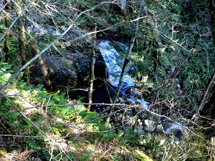
After you take a quiet breather to enjoy the sights, start heading back downhill. That tall mountain to your left will be Hamilton. As you backtrack about half-way down to Carpenters Lake, watch for the aforementioned trail junction on your left. You should see a small clearing here. This is where the Cedar Falls Trail starts. There is some disagreement among locals about the naming of this trail and the falls it takes you past (Incidentally, if you look north at this junction, there is a very light trail that heads north atop a ridge parallel to the Aldrich Butte Road: it leads toward the PCT and Heartbreak Ridge Trail). On the Cedar Falls Trail, head southwest down Aldrich Butte’s western slope. Past a large, decaying log, the road bed becomes a trail. Then, briefly, the trail uses an alder-colonized road bed again before dropping down the hillside. Switchback between two Douglas-firs, and then switchback again at the Cedar Falls-Aldrich Butte Cutoff Trail Junction: the latter trail leads out to the former Aldrich Butte Trailhead. Reach the cedar groves at the Cedar Creek Crossing. At times of high water, you can head about 100 yards downstream and, past a large grand fir with an old growth Douglas-fir looming up the slope, cross on a mossy log that has been refurbished to provide better footing; during dry periods, the main crossing is an easy rock hop.
To your right about five feet and across the stream is the continuation of the trail. Stop to refill your water and enjoy the cool breeze, then pick up the trail again. You are now on territory purchased by the Friends of the Columbia Gorge Land Trust in 2014. The trail follows the right side of the creek for a while and then begins an uphill traverse. Soon you’ll see a small 10-foot waterfall, Upper Cedar Falls, to your left. After this, the creek disappears into nowhere over Cedar Falls. The trail opens up to a viewpoint here, and traverses a hillside. You’ll get another very unique view of Hamilton Mountain here. Keep your eyes out looking downhill to your left for a view of the falls. When the foliage is thick and the flow is light, it may be a little hard to spot, but it will be pretty obvious from the small canyon where it is positioned. There is a way to get down to the falls – but it's not here!
Just after this viewpoint, the trail takes a hard turn right at a large burnt snag at the four-way junction with the Cedar Mountain Trail (See the Cedar Mountain Loop Hike). The rough, steep trail down to Cedar Falls drops down the ridge crest to the left and switchbacks at a stump. Switchback twice more and reach the alder-shaded creek. There are good views of the 70-foot three-tiered falls from the creek bank; the falls are best seen from late fall to spring, when the water levels are high and the leaves have dropped from the alders: in summer, they become a mere trickle. The falls pours over a shelf of conglomerate from the Eagle Creek Formation, sediments laid down during the Miocene before the massive Columbia River basalt flows.
Return to the Cedar Falls-Cedar Mountain Trail Junction; on your way up, you might see a use trail splitting off to the left, which will connect you with the Cedar Falls Loop in a cottonwood swamp – it’s best however, to stick to established trails and avoid creating new ones. At the junction, go left: this is the Giant Forest Trail, and it descends past a massive Douglas-fir to the Giant Forest-Hamilton Cutoff Trail Junction in an expansive, swampy bowl of alders, maples, and cottonwoods.
Take a left here, and hike down through the bowl. In places, the trail might be under water: this is an unusual ecosystem in the Gorge, so tread lightly. Soon, head out of the bowl and switchback in coniferous woods before dropping and passing a sign marked “Hamilton Cutoff” on a tree. Rise again, then drop and make a traverse, getting views of wide Hamilton Creek flowing below. Pass between two big Douglas-firs at a depression and note a tall seasonal waterfall pouring down the east slope of Hamilton Mountain to the left. You’ll walk by a big Douglas-fir slowly getting strangled by its cable noose and then switchback down to pass under a fallen tree. Hike up to the big slide (2006) at the Hamilton Creek Viewpoint.
From here, the trail switchbacks down to the old logging railroad grade. Hike up this corridor to a mossy fire circle at Railroad Camp. Then reach another slide area and notice a trail leading up to the right at the Giant Forest Trail-Hamilton Railroad Grade Junction. Hike up with an eroded gully to the left and enter a grove of cedars and cottonwoods, where you cross an old rock slide (The Giant Forest Trail actually crosses a section of Beacon Rock State Park here). Keep rising, noting many large Douglas-firs, and pass through another cedar grove to reach a saddle. Descend along the edge of the maple/cottonwood swamp to reach the Giant Forest-Hamilton Cutoff Trail Junction. Go left here, and ascend to the Cedar Falls-Cedar Mountain Trail Junction. Continue straight to return the way you came.
Maps
- Maps: Hike Finder
Note that only the Pacific Crest Trail part of the route is shown on these maps:
- Green Trails Maps: Bonneville Dam, OR #429
- Green Trails Maps: Columbia River Gorge - West #428S
- Geo-Graphics: Trails of the Columbia Gorge
- U.S. Department of Agriculture, Forest Service/Bureau of Land Management: Columbia River Gorge
- U.S. Department of Agriculture, Forest Service: Mt. Adams Ranger District
- U.S. Department of Agriculture, Forest Service: Gifford Pinchot National Forest
Regulations or restrictions, etc
- Northwest Forest Pass required
- $2 toll each way at the Bridge of the Gods
Trip Reports
- Search Trip Reports for Aldrich Butte-Cedar Falls Loop Hike
Related Discussions / Q&A
- Search Trail Q&A for Aldrich Butte-Cedar Falls Loop Hike
Guidebooks that cover this hike
- Day Hikes in the Columbia Gorge by Don J. Scarmuzzi (former access)
More Links
- Aldrich Butte: Hiking, History, and a Waterfall Too (Hiking Northwest)
- "Aldrich Butte, Washington" (The Columbia River: A Photographic Journey)