Barrett Spur/Dollar Lake Fire Damage - 10/16/11

This forum is used to share your experiences out on the trails.
User avatar
Born2BBrad
Posts: 1086
Joined: May 1st, 2011, 7:26 pm
Location: The Dalles

Barrett Spur/Dollar Lake Fire Damage - 10/16/11

Post by Born2BBrad » October 16th, 2011, 8:34 pm

On the direct north side of Mt. Hood is a ridge called Vista Ridge. At the very south end of Vista Ridge as it nears Mt. Hood is a spur that gets even higher and closer to Mt. Hood called Barrett Spur.

On Sunday, October 16th, Hiker Chris and I took advantage of one more good weather day to hike Barrett Spur. Both of us had been there before several times, so we knew what to expect.

I left both dogs at home. The hike would be too tough for Timmy and his old bones and too dangerous for Buddy. Now the question was, how do I get out of the house without them knowing I was going hiking without them? The first thing I did was prepare my gear the night before in the garage. They know that hiking gear equals "Go for a hike!" I though, out of sight, out of mind. The morning of the hike, somehow they knew what was going on. When I put on my hiking clothes, the jig was up. To distract their thoughts when I put them in the dog run before leaving, I threw the previous night's leftover popcorn in the grass. They were busy scarfing down their treat while I slipped away.

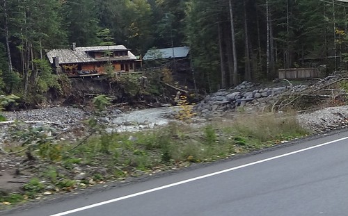
On the way to the trailhead, while driving on Lolo Pass road, we passed the area devastated by the Sandy River in January 2011. The flood was so powerful it washed out hundreds of feet of Lolo Pass road and washed away several homes. Several more homes are still in danger of being washed into the river if another flood comes. Sometimes rivers want to go where they want to go and there's nothing you can do about it.

Sandy River Flood Damage
Image

Barrett Spur can be reached a number of ways. Chris and I have always taken the Vista Ridge trail to Wy'East Basin, then gone straight up. This time was no exception.

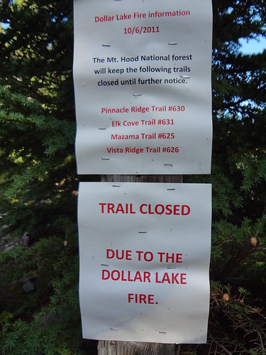
When we got to the Vista Ridge trailhead (4540'), we were met with a notice stating that this trail, along with other nearby trails were closed. Normally I am not a rule breaker, but since the Dollar Lake Fire had been out for weeks, we continued on. If the trail was really closed, why was there not a notice way down the road? We were curious how much of the burn area we would see. We soon found out.

Vista Ridge Trail Closed
Image

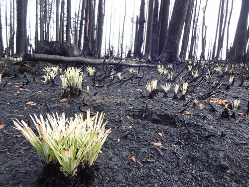
In less than a half a mile from the trailhead is the wilderness register. Right after that the burn area begins and continues almost up to where the Vista Ridge trail meets the Timberline trail. In most of the area the fire burned everything down to the ground with almost nothing surviving. You know that smell when you douse a campfire with water and it smolders? That's what it smelled like.

Burnt Bear Grass: Due to the rhizomes (roots) under ground, bear grass is often times the first plant to grow after a fire.
Image

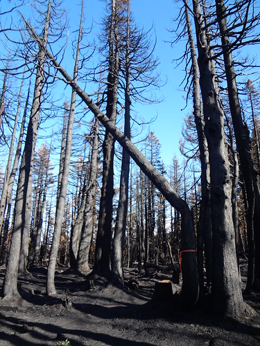
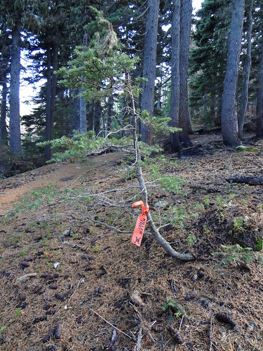
We soon noticed that some of the burnt trees along the trail had some orange tape around them. The tape read "Killer Trees" and had a skull and crossbone image. Upon further investigation, those trees had their insides almost completely burned out, making them a candidate for toppling over, possibly onto some unfortunate hiker.

Killer Tree 1: This tree had its insides burned out
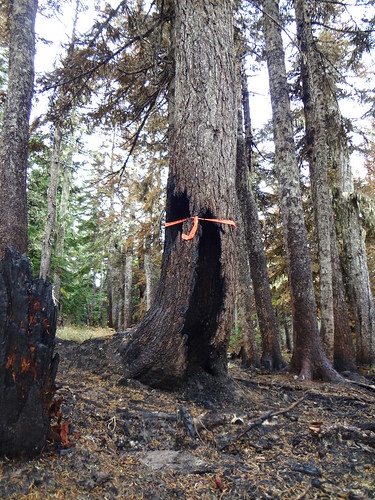
Image

Killer Tree Tape
Image

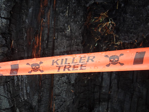
There were several trees with the Killer Tree tape that had fallen or toppled. Clear evidence that the tape was warranted. We made sure to stay clear of trees with the Killer Tree tape. If it was windy I would be reluctant to hike through this burned area. Trees will be crashing down for years to come.

Killer Tree 2: Toppled Killer Tree
Image

Killer Tree 3: I guess someone thought this tree was dangerous too.
Image

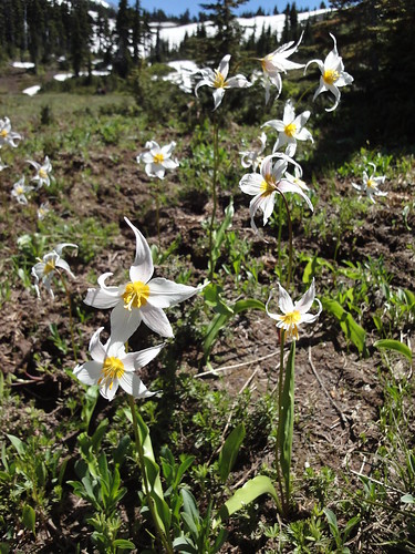
After hiking through the burned area, we were soon at Wy'East Basin (5900'). Wy'East Basin is a small meadow with beautiful views of Mt. Adams, Mt. Rainier and the tip of Mt. Hood. At certain times of the years wildflowers abound. There is also a year-round stream running through it. The name Wy'East is what Native Americans called Mt. Hood.

Avalanche Lilies At Wy'East Basin: Photo taken on a previous trip. Included here because I like this picture.
Image

Now the hard part began. From Wy'East Basin the trail gains 2150' in 1.7 miles to the high point of Barrett Spur at 7850'. Much of that mileage is over sandy ground, loose rock, rocks or boulders.

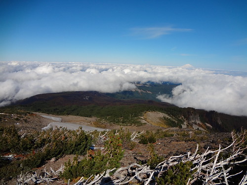
As we gained elevation, the tops of Mt. St. Helens, Mt. Adams and Mt. Rainier began to be seen above the ever-diminishing clouds. And of course the view of Mt. Hood got bigger and bigger. The Dollar Lake Fire burn area became more clear. The burned area was fairly thin, like a ribbon, as opposed to being blocky or circular.

On The Way To Barrett Spur: The view as we climbed higher. The Dollar Lake Fire area can be seen.
Image

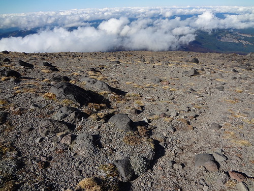
As the trail gets near the base of Barrett Spur there is an alpine area of nothing but rocks. I call this the Rock Garden. This is where the trail becomes ambiguous. It braids around rocks, meeting up, and then splitting again. It's never hard to find your way because Barrett Spur is right there.

Rock Garden
Image

Shortly before getting to the Rock Garden, the wind picked up. Soon it was a continuous 30 MPH. With the temperature at 45 degrees, it got quite nippy, even with the sun shining. Good thing we were prepared and brought hats, gloves and wind breakers.

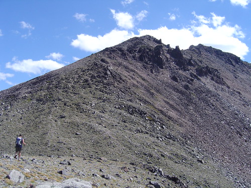
Now the really hard part began. Climbing Barrett Spur is incredibly difficult due to the steepness and loose rocks and boulders. The trail, if you can call it that, is not easy to follow. The rocks and boulders that must be traversed can be unstable. If are afraid of heights and are not sure-footed like a mountain goat, you should avoid attempting to climb Barrett Spur.

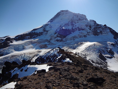
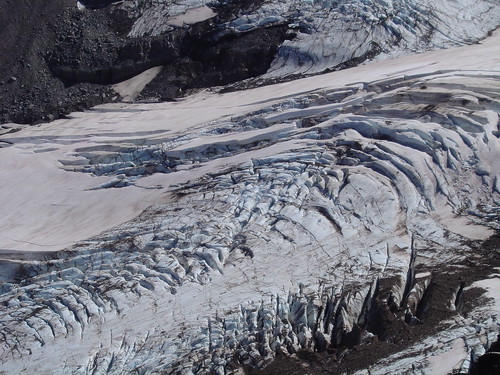
If you do go, the effort is well worth it. The view from the high point of Barrett Spur is beyond spectacular. Besides the mountain views previously described, Barrett Spur has two glaciers flowing on either side. The Coe Glacier on the left and the Ladd Glacier on the right. Barrett Spur is so close to the Coe and Ladd Glaciers that I could hear them cracking. It sounds like rocks falling.

Barrett Spur
Image

Mt. Hood From Barrett Spur
Image

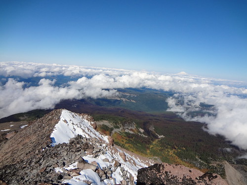
Looking North From Barrett Spur High Point
Image

Coe Glacier
Image

Link to a 360 video taken from the high point of Barrett Spur. It's a little shaky because I was spinning around on a rock near a cliff.
http://www.flickr.com/photos/54959080@N ... 7786558717

Chris and I were going to check out Eden Park and Cairn Basin as a side trip, but that would have added about 2.5 miles and we were tired.

Total mileage: 9 miles round trip (approx.)
Total elevation gain: 3310'

Good hiking,
Brad
Make now always the most precious time. Now will never come again.
- Jean Luc Picard

Link to GPX tracks
Link to Trip Reports

User avatar
Grannyhiker
Posts: 4598
Joined: May 28th, 2008, 10:03 pm
Location: Gateway to the Columbia Gorge

Re: Barrett Spur/Dollar Lake Fire Damage - 10/16/11

Post by Grannyhiker » October 16th, 2011, 9:29 pm

Glad you didn't get caught! Thank you for the photos!

You didn't include a current photo of Wy'East Basin; did it burn too? From the fire perimeter maps on InciWeb, it looked as though that area was spared.

I think we're going to find things quite different up there next summer!

Thum

Re: Barrett Spur/Dollar Lake Fire Damage - 10/16/11

Post by Thum » October 16th, 2011, 9:33 pm

wow, incredible photos brad. the regeneration photo is amazing.

User avatar
Splintercat
Posts: 8334
Joined: May 28th, 2008, 10:03 pm
Location: Portland
Contact:

Re: Barrett Spur/Dollar Lake Fire Damage - 10/16/11

Post by Splintercat » October 16th, 2011, 9:58 pm

Thanks, Brad... even though you'll fry in HELL for walking past those signs... :lol:

Your large Flickr versions are the first/best detail I've seen of the Timberline Trail area, and it looks largely spared by the fire. Even that gorgeous old stand of mountain hemlock along the west slope of Elk Cove is a mosaic burn, so some of the real giants there looked to be spared, too -- along with most of Elk Cove.

The shot on your Flickr page of the snags in the fog is very cool, by the way!

-Tom :)

User avatar
mayhem
Posts: 3579
Joined: December 22nd, 2009, 7:46 pm
Contact:

Re: Barrett Spur/Dollar Lake Fire Damage - 10/16/11

Post by mayhem » October 16th, 2011, 10:09 pm

Yes thanks for sharing Dude...but you freaked me out just a little bit!
(Link to a 360 video taken from the high point of Barrett Spur. It's a little shaky because I was spinning around on a rock near a cliff) Are you kidding??
Shoe Shine Boy Has Left The Building!

User avatar
Grannyhiker
Posts: 4598
Joined: May 28th, 2008, 10:03 pm
Location: Gateway to the Columbia Gorge

Re: Barrett Spur/Dollar Lake Fire Damage - 10/16/11

Post by Grannyhiker » October 16th, 2011, 10:24 pm

There's quite a bit of green in some of your photos! Especially in the background of the third "Killer Tree." (I suspect that was a prank. :lol: ) Also the first (real) Killer Tree. I have a suspicion the USFS will want to cut those down before letting folks up there next year if they don't come down of their own accord this winter.

Thank you for what are probably the first photos (or at least the first published photos) of the fire area since the ones taken during the fire!

Interesting that, unlike up in Washington, there's no snow on the ground yet.

User avatar
anne37
Posts: 231
Joined: October 7th, 2010, 12:15 am
Location: NW Portland
Contact:

Re: Barrett Spur/Dollar Lake Fire Damage - 10/16/11

Post by anne37 » October 17th, 2011, 12:32 am

Great report, and quite surprised to see that there's not as much new snow as I thought. Maybe Saturday's hike will be on Mount Hood after all! :)

User avatar
Grannyhiker
Posts: 4598
Joined: May 28th, 2008, 10:03 pm
Location: Gateway to the Columbia Gorge

Re: Barrett Spur/Dollar Lake Fire Damage - 10/16/11

Post by Grannyhiker » October 17th, 2011, 10:48 am

Do remember that the Forest Service reads these posts!

User avatar
Born2BBrad
Posts: 1086
Joined: May 1st, 2011, 7:26 pm
Location: The Dalles

Re: Barrett Spur/Dollar Lake Fire Damage - 10/16/11

Post by Born2BBrad » October 17th, 2011, 2:54 pm

Grannyhiker wrote:Glad you didn't get caught!
Me too! Now that I have more information, I checked the MHNF website and it is posted there about the trail closures. There they also mention a fine. That was not noted at the trailhead. Nevertheless, if a notice was posted way down on the road, we would have been able to alter our plans before finishing the drive.
Grannyhiker wrote: You didn't include a current photo of Wy'East Basin; did it burn too? From the fire perimeter maps on InciWeb, it looked as though that area was spared.
Wy’East Basin was entirely spared. From above it looked like much, if not all of the Timberline Trail was bypassed by the fire, as well.
Grannyhiker wrote:There's quite a bit of green in some of your photos! Especially in the background of the third "Killer Tree." (I suspect that was a prank. :lol:
I may know who tied that one on the tree, but I’m not saying anything :>)
Grannyhiker wrote:Do remember that the Forest Service reads these posts!
I am curious if that’s true. If so, how come they don’t seem to know very much about trail conditions provided by PH members? Maybe the information does not get passed on to the appropriate people.
Thum wrote:wow, incredible photos brad. the regeneration photo is amazing.
Thanks. I thought the contrast of nearly complete destruction with a little bit of life was interesting.
mayhem wrote:Yes thanks for sharing Dude...but you freaked me out just a little bit!
(Link to a 360 video taken from the high point of Barrett Spur. It's a little shaky because I was spinning around on a rock near a cliff) Are you kidding??
It wasn’t as bad as it sounds. The cliff was 2 feet away, the rock was flat, and I was looking mostly at my feet as I filmed. I’ve seen Don Nelson do way more scary things, like rappel up and down a cliff, scramble up Indian Point and snowshoe up to Sturgeon Rock.
Splintercat wrote:Thanks, Brad... even though you'll fry in HELL for walking past those signs... :lol:
Your large Flickr versions are the first/best detail I've seen of the Timberline Trail area, and it looks largely spared by the fire. Even that gorgeous old stand of mountain hemlock along the west slope of Elk Cove is a mosaic burn, so some of the real giants there looked to be spared, too -- along with most of Elk Cove.
The shot on your Flickr page of the snags in the fog is very cool, by the way!
-Tom :)
Yeah, I might not break the rules again now that I am aware of the closure and the fine. I’m glad you liked the Flickr photos. I have been neglecting to include a link to all the photos in my TRs since I began using a different posting format. I’ll remember to include that in future TRs.
Make now always the most precious time. Now will never come again.
- Jean Luc Picard

Link to GPX tracks
Link to Trip Reports

User avatar
Water
Posts: 1356
Joined: May 28th, 2008, 10:03 pm

Re: Barrett Spur/Dollar Lake Fire Damage - 10/16/11

Post by Water » October 17th, 2011, 3:35 pm

Disclaimer: Information found on PortlandHikers.org and PortlandHikersFieldGuide.org is provided by website visitors and volunteers and should be considered anecdotal. All trails and directions and subject to current conditions. Trails and roads can be rerouted due to natural events and the website is not able to provide current information for every hike. Please verify against two other sources before planning a trip. Outdoor activities present inherent risks. Portlandhikers.org, nor any of its members, accept liability for injuries relating to information found on this website.
the TOS here says it is against the rules to make posts that break the law (like harassment, hate speech, etc). I don't know that there is any law against posting pictures from or talking about a closed area.

I think if the FS reads these forums they might only "read it for the pictures" because their reading comprehension sucks for learning about 'conditions' from information here and actually getting that information available to the public via their office phone people or the 1999geocities caliber website they slap their name on.

I had a friend who climbed hood yesterday, I'll see if they have any good pics down of the north side, might give a great overview of the burn.

Nice to see your report of things up there - glad i was able to hike most of it in previous years, before this fire came through.
Feel Free to Feel Free

Post Reply