The purpose of this forum is to help people identify things they've seen while out hiking: wildflowers, trees, birds, insects, small animals, animal tracks, even geographical features like buttes or streams
-
awildman
- Posts: 918
- Joined: June 6th, 2009, 5:20 pm
- Location: Portland
Post
by awildman » February 23rd, 2013, 9:22 pm
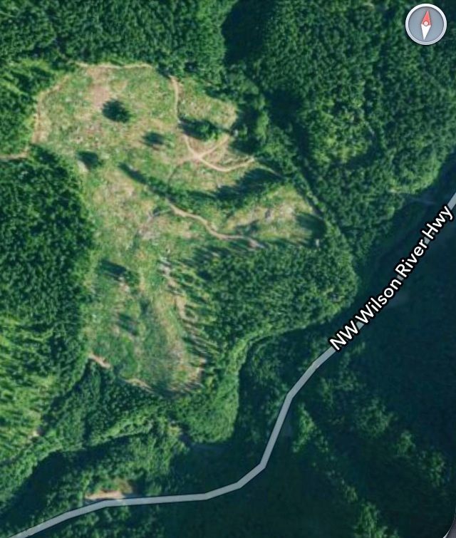
I was poking around the southwestern part of the Wind Rivers area in Washington on skis and came across this remarkable clear cut pattern.
Does anyone know why it has such a distinct pattern? Random or best practice?
It's accessed from the Hardtime Loop (FR 3054) or cross-country from FR 31.

-
arundodonax
- Posts: 1043
- Joined: August 12th, 2010, 8:02 pm
Post
by arundodonax » February 23rd, 2013, 9:35 pm
I'm gonna roll the dice and say that's not random.
-
BrianEdwards
- Posts: 2405
- Joined: February 2nd, 2010, 1:32 am
- Location: Oregon City, OR
-
Contact:
Post
by BrianEdwards » February 23rd, 2013, 9:39 pm
Someone 'Forever Alone'd' a clear cut on Idiot Creek in the coast range.

There's an interesting clearcut near Defiance that I can't find at the moment.
-
Peabody
- Posts: 524
- Joined: August 12th, 2011, 8:37 pm
Post
by Peabody » February 23rd, 2013, 10:17 pm
"I arise in the morning torn between a desire to improve the world and a desire to enjoy the world. This makes it hard to plan the day.”
― E.B. White
-
raven
- Posts: 1531
- Joined: May 28th, 2008, 10:03 pm
Post
by raven » February 24th, 2013, 12:19 pm
Within about a mile to the northeast and two miles in the south to east quadrant there are a series of oddly patterned cuttings.
http://www.mappingsupport.com/p/gmap4.p ... eetview=on
Higher altitude than others I've seen, but seems to me likely to be work that's part of the Wind River Experimental Forest. Just a guess at this point.
-
vibramhead
- Posts: 810
- Joined: November 15th, 2009, 10:52 am
- Location: SW Portland
Post
by vibramhead » February 24th, 2013, 12:54 pm
Peabody, thanks for resolving that mystery. I spotted those odd clearcuts a few years ago when I downloaded a GPS track into a map program on my computer after a ski trip at Oldman Pass, and I couldn't figure out why anyone would log that way.
-
awildman
- Posts: 918
- Joined: June 6th, 2009, 5:20 pm
- Location: Portland
Post
by awildman » February 24th, 2013, 1:13 pm
Mystery solved! Thanks, Peabody. I saw the 40% aggregated-retention treatment.
"Declines in species frequency and richness were consistently greater in the harvested areas of aggregated treatments than in dispersed treatments."
-
raven
- Posts: 1531
- Joined: May 28th, 2008, 10:03 pm
Post
by raven » February 24th, 2013, 3:29 pm
Thanks, Peabody. I didn't see your post when I read the thread.
Interesting politics involved. In the 1970s the Forest Service decided that cuts under 40 acres would not be called "clear cuts" in a fairly obvious attempt to minimize scrutiny. (Worked, iirc, until someone noticed.) In the research projects described the plots are 32 acres.
One summer bushwhacking on a south-facing slope back to a trailhead by Washington 12 east of White Pass, I noticed the Forest floor becoming drier and the apparent species composition changing. That occurred about 1/4 mile before reaching or even noticing the edge of a clearcut. 32 acre sites are not large enough for uncut controls if one is concerned with replicating species; 160 acres would be marginal near the middle; a mile circle, about 480 acres, would provide a half-mile circle 120 acres in extent that would be a better barometer of species survival while permitting uniformity of the plot to be analyzed.
Of course, while studies continue, it can be business as usual since the alternatives are "unproven".
Sorry about the thread hijack -- I wanted to vent.
-
awildman
- Posts: 918
- Joined: June 6th, 2009, 5:20 pm
- Location: Portland
Post
by awildman » February 24th, 2013, 3:51 pm
It's a relevant vent.

-
retired jerry
- Posts: 14417
- Joined: May 28th, 2008, 10:03 pm
Post
by retired jerry » February 24th, 2013, 4:14 pm
I used to go to 8 mile campground, East of Mt Hood, West of Dufur, maybe 5 years ago was the last time.
Between there and Camp Baldwin there were several clearcuts about 50 acres maybe.
Over 10 years, I noticed they never replanted them.
I wonder how they're doing now? I'll have to go up and check.