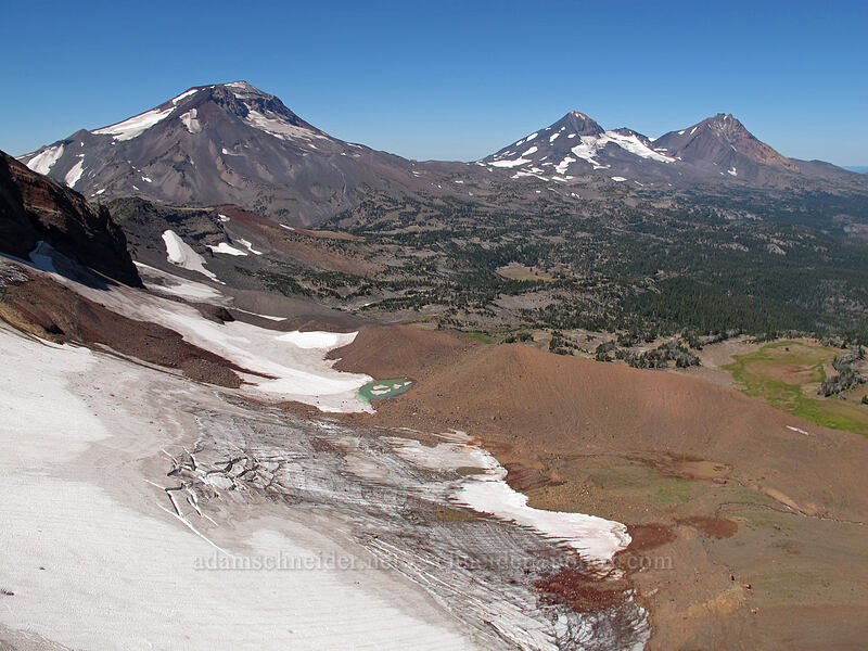
Broken Top from Broken Top trail head

Trip recommendations, current conditions, and other trail related Q&A
User avatar
adamschneider
Posts: 3716
Joined: May 28th, 2008, 10:02 pm
Location: SE Portland
Contact:

Re: Broken Top from Broken Top trail head

Post by adamschneider » February 7th, 2018, 11:40 pm

LDG wrote:Bad road (the quality doesn't bother me as long as I can drive it in a pickup), but the hike is much shorter? I want to use this trail because a 12 mile hike is just beyond our capabilities right now.
It's about 12 miles to the summit no matter which trailhead you use. The Broken Top and 370/380 trailheads are further from the highway, but to get to the summit you'll have to go all the way west to Green Lakes anyway.

The GraphHopper link you posted is a hike to "No-Name Lake," NOT to Broken Top's summit. If that's your goal, then yes, the Broken Top Trailhead is by far the shortest option. (You can get to No-Name Lake from Three Creeks Lake, which has a good road, but the route is twice as far.) And, reading your first post again, I'm guessing this IS in fact your goal; "up and down Broken Top in a day" made us think you wanted to summit.

LDG
Posts: 13
Joined: February 6th, 2018, 4:41 pm

Re: Broken Top from Broken Top trail head

Post by LDG » February 8th, 2018, 12:27 am

adamschneider wrote:
LDG wrote:Bad road (the quality doesn't bother me as long as I can drive it in a pickup), but the hike is much shorter? I want to use this trail because a 12 mile hike is just beyond our capabilities right now.
It's about 12 miles to the summit no matter which trailhead you use. The Broken Top and 370/380 trailheads are further from the highway, but to get to the summit you'll have to go all the way west to Green Lakes anyway.

The GraphHopper link you posted is a hike to "No-Name Lake," NOT to Broken Top's summit. If that's your goal, then yes, the Broken Top Trailhead is by far the shortest option. (You can get to No-Name Lake from Three Creeks Lake, which has a good road, but the route is twice as far.) And, reading your first post again, I'm guessing this IS in fact your goal; "up and down Broken Top in a day" made us think you wanted to summit.
Holy crap, you're right! I completely missed that! I can see where I caused confusion, my mistake!

Now that we're all closer to the same page about hiking to No Name Lake and probably up the Northern edge so I can get views of the Sisters, what are recommendations for the road to the trail head? It sounds like it will be more than possible in a pick up? What would be the lowest clearance vehicle advised?

User avatar
Don Nelsen
Posts: 4380
Joined: May 28th, 2008, 10:03 pm
Location: Vancouver, WA

Re: Broken Top from Broken Top trail head

Post by Don Nelsen » February 8th, 2018, 11:13 am

LDG wrote:
Don Nelsen wrote:
LDG wrote:
I have seen that parking area on Google Maps and in some youtube videos. That is part of what gives me encouragement because there are a few cars there. I'd love anything you have of that area! I'm trying to do as much research on this as the internet will allow. Right now, it is sounding like all that might prevent this trek is a bad winter hurting the road.
Here are the photos I took that day. I'm the guy in the red shirt. I still have the GPS track but I must do a little research to find it.

http://www.fototime.com/users/donnelsen ... 0side%20TH

dn
Cool! That summit looks fine. I've read some horror stories about needing ropes, but it just didn't make sense from this way. Having anything of the road?
No, no pics of the road but I'll ask the other folks who were along for the hike if they have anything. As for the last pitch up the summit block: Go around to the left as you approach (north side) and it's a fairly straightforward scramble. Loose in spots but not really that steep.
"Everything works in the planning stage" - Kelly

"If you don't do it this year, you will be one year older when you do" - Warren Miller

LDG
Posts: 13
Joined: February 6th, 2018, 4:41 pm

Re: Broken Top from Broken Top trail head

Post by LDG » February 8th, 2018, 12:56 pm

Don Nelsen wrote:
As for the last pitch up the summit block: Go around to the left as you approach (north side) and it's a fairly straightforward scramble. Loose in spots but not really that steep.
As Adamschneider helped me realize, my target is not actually the summit, but simply No Name Lake and the crest just North of it that provides a view of the Sisters. It is sounding more and more like this hike will not be a problem, so much as the road could be.

User avatar
Don Nelsen
Posts: 4380
Joined: May 28th, 2008, 10:03 pm
Location: Vancouver, WA

Re: Broken Top from Broken Top trail head

Post by Don Nelsen » February 8th, 2018, 3:46 pm

LDG wrote:
Don Nelsen wrote:
As for the last pitch up the summit block: Go around to the left as you approach (north side) and it's a fairly straightforward scramble. Loose in spots but not really that steep.
As Adamschneider helped me realize, my target is not actually the summit, but simply No Name Lake and the crest just North of it that provides a view of the Sisters. It is sounding more and more like this hike will not be a problem, so much as the road could be.
Should be a breeze since the terrain up to the lake is wide open. It's only about 2 1/2 miles to the lake depending on how much zig-zagging you do on the way. Here's a photo of the route's terrain taken from the summit of Broken Hand, Aug. 27th, 2014:
Image

The Lake:
Image

Image

The view from the crest you mention:

Image

A spectacular place to visit - hope you have fine weather.

dn
"Everything works in the planning stage" - Kelly

"If you don't do it this year, you will be one year older when you do" - Warren Miller

User avatar
adamschneider
Posts: 3716
Joined: May 28th, 2008, 10:02 pm
Location: SE Portland
Contact:

Re: Broken Top from Broken Top trail head

Post by adamschneider » February 8th, 2018, 4:07 pm

Don Nelsen wrote:The view from the crest you mention:
What crest were YOU on? My view was way better! :lol:

Image

User avatar
Don Nelsen
Posts: 4380
Joined: May 28th, 2008, 10:03 pm
Location: Vancouver, WA

Re: Broken Top from Broken Top trail head

Post by Don Nelsen » February 8th, 2018, 4:18 pm

adamschneider wrote:
Don Nelsen wrote:The view from the crest you mention:
What crest were YOU on? My view was way better! :lol:

Image
Nice! I guess your photo separates you pros from us amateurs :)
"Everything works in the planning stage" - Kelly

"If you don't do it this year, you will be one year older when you do" - Warren Miller

User avatar
adamschneider
Posts: 3716
Joined: May 28th, 2008, 10:02 pm
Location: SE Portland
Contact:

Re: Broken Top from Broken Top trail head

Post by adamschneider » February 8th, 2018, 6:07 pm

Don Nelsen wrote:Nice! I guess your photo separates you pros from us amateurs :)
Nah, I just meant that yours was partially obstructed by low ridges in the foreground. I think you took your picture from lower down and further east, maybe near Broken Hand.

LDG
Posts: 13
Joined: February 6th, 2018, 4:41 pm

Re: Broken Top from Broken Top trail head

Post by LDG » February 10th, 2018, 6:55 am

Another quick question regarding the lake...I've seen pictures of people floating in it. Are they polar plunge candidates or is it somehow a reasonable temperature?

User avatar
adamschneider
Posts: 3716
Joined: May 28th, 2008, 10:02 pm
Location: SE Portland
Contact:

Re: Broken Top from Broken Top trail head

Post by adamschneider » February 10th, 2018, 8:13 pm

LDG wrote:Another quick question regarding the lake...I've seen pictures of people floating in it. Are they polar plunge candidates or is it somehow a reasonable temperature?
The lake is frozen over for most of the year and is fed by meltwater from snowfields. You do the math!

Post Reply