
2 weeks ago we planned on Mississippi Head, got to Split Rock, climbed it for a better view, and confusion set in. Started in what I am thinking was the right direction, met a hiker returning. He thought there was no way to reach it from there so we backtracked to the gulley/canyon and based on the view from Split Rock it looked like if you made it up to other side there was a clear ridge to below MH. Well looks are deceiving. It was a very loose scramble that we decided wasn't very smart about half way up. Got down, and went back to Timberline defeated.
GPS track here: http://gpsfly.org/g/7377
So not one to be beat by some rock and ice, we're going back Sunday. Found some nice trip reports but they were older. Has anybody done this recently? Is there another way not via Split Rock? Any tip for getting from Split Rock to MH? It looks like 778 heads there but just disappears.
Much appreciated.
Mississippi Head

Re: Mississippi Head
The easiest is to follow the faint trail on the western side of the Zigzag Canyon that leads up to Mississippi Head; there is a "Paradise Loop" post where it starts (N45° 20.933' W121° 44.845'). The Head itself is accessed by a snow/ rubble slope. I like to continue up and cross over to the Timberline ski trails; to that end you need to be at 8,000' to cross above the top (upper end) of the Zigzag Canyon. Traction devices such as microspikes are always a plus on a hike like this.
It can also be done from Split Rock, but the terrain is a bit rougher and there is no trail.
It can also be done from Split Rock, but the terrain is a bit rougher and there is no trail.
Some people are really fit at eighty; thankfully I still have many years to get into shape…
Re: Mississippi Head
Thanks for replying Peder. So 778 is the way then. Line of sight after the trail peders out.
Always carrying my Hillsounds. They are great trail crampons.
And I plan on getting up over Zig Zag and down beneath the lifts.
Always carrying my Hillsounds. They are great trail crampons.
And I plan on getting up over Zig Zag and down beneath the lifts.

Re: Mississippi Head
Went up there a week ago today, using the route Peder suggests. Then, rather than continue up and across to Timberline, I came back down on the "normal" Split Rock route (for awhile, before diverting along the Sandy drainage), to enjoy a second showing of the Paradise bloom. Here's the track...
Definitely bring spikes. There's one remaining snowfield at about a 30° pitch. After 1-2 pm, that day, it was in a state of "too hard to kickstep, too soft for spikes to bite." Looked like plenty of snow still at the 8000' crossover, too.
Definitely bring spikes. There's one remaining snowfield at about a 30° pitch. After 1-2 pm, that day, it was in a state of "too hard to kickstep, too soft for spikes to bite." Looked like plenty of snow still at the 8000' crossover, too.
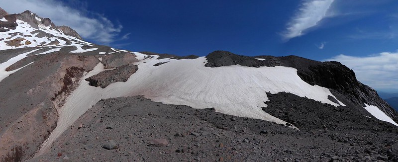
I angled upwards to the right from that dusty area, 15-Aug-2017.
Karl
Back on the trail, again...
Back on the trail, again...
Re: Mississippi Head
Awesome man. Thanks for GPS track and photo of the route up MH.kepPNW wrote:Went up there a week ago today, using the route Peder suggests. Then, rather than continue up and across to Timberline, I came back down on the "normal" Split Rock route (for awhile, before diverting along the Sandy drainage), to enjoy a second showing of the Paradise bloom. Here's the track...
Definitely bring spikes. There's one remaining snowfield at about a 30° pitch. After 1-2 pm, that day, it was in a state of "too hard to kickstep, too soft for spikes to bite." Looked like plenty of snow still at the 8000' crossover, too.
I angled upwards to the right from that dusty area, 15-Aug-2017.
Re: Mississippi Head
My pleasure. More almost-current conditions photos in my sig link (or clicking through on the one I posted). Enjoy!Arturo wrote:Awesome man. Thanks for GPS track and photo of the route up MH.
Karl
Back on the trail, again...
Back on the trail, again...

Re: Mississippi Head
Just completed "Timberline Lodge -> PP ->Mississippi Head -> Palmer" loop Sunday. Here is the track:
http://www.gpsvisualizer.com/display/20 ... 8-map.html
http://www.gpsvisualizer.com/display/20 ... 8-map.html
Re: Mississippi Head
In all but summer and fall you can do something similar as a fun ski loop and let the chairlift do all the work for you, or not.  Starting at top of Palmer, traverse across to the west and down ZigZag glacier to the top of ZigZag Canyon above Mississippi Head. Then head towards Timberline until you get to the top of Little Zig Zag Canyon. You still have enough elevation to drop into Little Zig Zag and ski down and up the other side. When you pop out just traverse towards Timberline, skiing as shallow a line as possible and you will hit the bottom of the Magic Mile chairlift.
I used to do this quite often and one March I happened upon a French extreme skier and watched him ski off the top of Mississippi Head and then pop a parachute.
I used to do this quite often and one March I happened upon a French extreme skier and watched him ski off the top of Mississippi Head and then pop a parachute.
Last edited by pcg on August 24th, 2017, 10:54 pm, edited 2 times in total.
Re: Mississippi Head
watched him ski off the top of Mississippi Head and then pop a parachute.
I'm not altogether sure that was a legal activity.
I'm not altogether sure that was a legal activity.
Re: Mississippi Head
Oh man, that's it!ssinfo503 wrote:Just completed "Timberline Lodge -> PP ->Mississippi Head -> Palmer" loop Sunday. Here is the track:
http://www.gpsvisualizer.com/display/20 ... 8-map.html
Looks like when you crossed Lost Creek you went up that ridge that we were trying to gain from the other side after we turned around past Split Rock.
I noticed that 778 goes more into the canyon before it disappears.
What made you go to the left before that?