
- Conditions Update: The Wygant and Chetwoot trails were badly damaged in the 2011-12 winter ice storms, with many trees down and tread damage to both trails. Hiking this route is not recommended at this time. (March 30, 2012)
Wygant Peak
Wygant Peak
Just scouting out future possibilities... The Field Guide says:
Karl
Back on the trail, again...
Back on the trail, again...
-
Don Nelsen

- Posts: 4382
- Joined: May 28th, 2008, 10:03 pm
- Location: Vancouver, WA
Re: Wygant Peak
I hiked this on 3/29/15 and had no problems. There were about 120 trees down across the trail to Wygant Peak but virtually every one had had some chain saw or axe notches to make them easy to cross over. All the downed trees were relatively small, under two feet diameter or so, as I remember.
Here are a few of the photos I took on the trip:
http://www.fototime.com/users/donnelsen ... p%20032915
dn
Here are a few of the photos I took on the trip:
http://www.fototime.com/users/donnelsen ... p%20032915
dn
"Everything works in the planning stage" - Kelly
"If you don't do it this year, you will be one year older when you do" - Warren Miller
"If you don't do it this year, you will be one year older when you do" - Warren Miller
Re: Wygant Peak
Hey, that's good to hear, Don! I'll go ahead and "add it to the list!" 
Thanks much...
Thanks much...
Karl
Back on the trail, again...
Back on the trail, again...
-
sprengers4jc

- Posts: 1036
- Joined: October 22nd, 2013, 11:35 am
- Location: Vancouver, WA
Re: Wygant Peak
Work was done recently on the trail and it looks like they logged out the lower reaches.
'We travel not to escape life but for life to not escape us.'
-Unknown
-Unknown
Re: Wygant Peak
Thanks, Keri! More good info to have. Too bad to hear about that bridge. Hopefully, most all the snow above it has already melted. 
Karl
Back on the trail, again...
Back on the trail, again...
Re: Wygant Peak
(Bosterson, take note.  )
)
Then again, keeping the warning there will leave the trail to just those of us who ignore most warnings. We only saw two other people all day!
So we went ahead and hiked this area on Saturday, 4/9. I'd say that warning should either be removed, or significantly amended. The Wygant trail is in superb shape! Seems like the recent work crews really did a great job. The Chetwoot trail, well, we decided to believe more recent reports of (as well as a TH sign implying) a landslide, and didn't test it north of the powerlines.kepPNW wrote:Just scouting out future possibilities... The Field Guide says:
Anyone know if this is still the case?
- Conditions Update: The Wygant and Chetwoot trails were badly damaged in the 2011-12 winter ice storms, with many trees down and tread damage to both trails. Hiking this route is not recommended at this time. (March 30, 2012)
Then again, keeping the warning there will leave the trail to just those of us who ignore most warnings. We only saw two other people all day!
Karl
Back on the trail, again...
Back on the trail, again...

Re: Wygant Peak
I've removed the warning in the Field Guide now, as per Karl's assurances.
Re: Wygant Peak
Just to be sure I was clear, we didn't follow the entire Chetwoot trail, and my understanding is that part of it is still impassable. We did go a short ways down from the upper junction, and it appeared to have hardly been traveled at all in quite some time. But the Wygant trail is in very fine condition, probably thanks to the folks in the link Keri offered above.bobcat wrote:I've removed the warning in the Field Guide now, as per Karl's assurances.
Karl
Back on the trail, again...
Back on the trail, again...

Re: Wygant Peak
It's been a number of years since I've hiked the Wygant Trail because it had suffered so severely from slides and tree fall. In looking at the trail tending report, I did not read that any work had been done above the loop, and that was where the worst of the trail issues were.
I don't hike at the gazelle pace nor do I posses the gymnastic balancing skills that Don has developed over his envious career on the trail, I'm more of a plod-along type of hiker, so I would want more clarification on what he encountered and whether or not it would be a problem to lessor mortals. In short, I would not be deleting that warning on the trail conditions until you have checked out the trail personally.
I don't hike at the gazelle pace nor do I posses the gymnastic balancing skills that Don has developed over his envious career on the trail, I'm more of a plod-along type of hiker, so I would want more clarification on what he encountered and whether or not it would be a problem to lessor mortals. In short, I would not be deleting that warning on the trail conditions until you have checked out the trail personally.
Re: Wygant Peak
The upper portion of the Wygant trail had, in fact, seemed to have gotten the most attention. It was exceedingly walkable, without any sort of heroics. There was one, maybe two, spots on Wygant where you had to scramble oh-so-slightly around a fallen tree or something. But they were very minor by nearly any measure, and even kids under five could navigate them with perhaps the gentlest of boosts. (As for kids, the worst would've been a few spots with slight exposure - a long tumble possible - and high winds.)BigBear wrote:It's been a number of years since I've hiked the Wygant Trail because it had suffered so severely from slides and tree fall. In looking at the trail tending report, I did not read that any work had been done above the loop, and that was where the worst of the trail issues were.
I don't hike at the gazelle pace nor do I posses the gymnastic balancing skills that Don has developed over his envious career on the trail, I'm more of a plod-along type of hiker, so I would want more clarification on what he encountered and whether or not it would be a problem to lessor mortals. In short, I would not be deleting that warning on the trail conditions until you have checked out the trail personally.
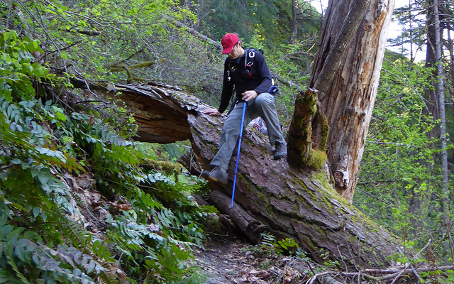
Maybe three or four logs this large to get over. All with footholds chopped on top.
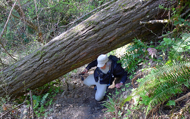
Two or three you had to scootch under, and then do a tick check afterwards.
Maybe a 100 or so you have to step over, or worst-case on and over.
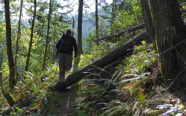
General condition above junction. Hold the kiddo's hand, here, if the wind's blowing.
Karl
Back on the trail, again...
Back on the trail, again...