Henline Mountain and Henline Falls 5/14/11

This forum is used to share your experiences out on the trails.
Post Reply
User avatar
jessbee
Posts: 877
Joined: May 28th, 2008, 10:03 pm
Contact:

Henline Mountain and Henline Falls 5/14/11

Post by jessbee » May 15th, 2011, 9:53 am

May 14, 2011.

The Henline Mountain Trail reaches into the Opal Creek Wilderness along the North Fork Santiam River. The trail begins from a roadside pullout and immediately begins switchbacking up 2200 vertical feet in 2.8 miles. I had never been here before, and I was hoping to get somewhere new that was low enough where snow might not be an issue.

Sue and I barreled up the mountainside at a slow and steady pace. I was hacking out my lungs, trying to get rid of a feisty cold that had been gripping me for the past two weeks. We stopped to ogle the wood violet and fairyslipper decorating the sides of the trail. The woods were pretty. I haven’t been out hiking much these past several weeks, as I have split my time writing a research paper and rock climbing in the dusty desert. It felt nice to be wrapped up with fog within a cool, green forest. We stopped at the 0.7 mile viewpoint to scramble out on to the rocky meadow and imagined the view we would have found on a clear day. We could hear the rushing river below. Sue spotted a buzzing, red hummingbird.
DSCN0920.JPG
Fairyslipper
DSCN0921.JPG
Viewpoint from Henline Mountain Trail
The trail continued at a consistent grade up and up and up. Nearing the top, we rounded a corner to find the trail buried under thick patches of snow. I hoped we would be able to avoid this, I thought… Soon the patches turned into full-on snow cover. We kicked side-steps into the steep snowfields. The snow had the consistency of Sno-cone ice. We followed what appeared to be the trail as it wound itself up and around the mountain. Since this was my first time here, I was a bit disoriented. Eventually I grew tired of trying to follow the trail and we decided to make a beeline towards what we thought was our destination.

We angled directly up the slope, using snow steps, tree belays, and careful walking over 45 degree slick vegetation and dirt. My eyes settled on a wickedly cool rock ridge; we followed the ridge on rocks and snow until the trail magically appeared again. Taking the path of least resistance, we continued along our trek. In places, the snow formed a perilously thin and slushy layer over huge holes created by the heat radiating from the rocks below. I poked test holes with my hiking poles as best I could so we could travel safely. I had far more practice doing stupid stuff like this than Sue had, so I took charge of finding the best footing and making nice snow steps.
DSCN0927.JPG
DSCN0932.JPG
After all that work, the trail dipped down into steep snow fields surrounded by menacing looking cliffs. There was a small wooded bump that we investigated, but to our dismay we could not determine where the old lookout platform could be. The clouds were so thick that our visibility was greatly compromised. We decided then to turn around and retrace our steps back to the trail.

Not wanting to give up just yet I followed one more hunch up another steep slope covered in slushy snow and slippery beargrass. The snowfield led me to another, somewhat wider ridge with a nice, flat snowbank on top. Just perfect for building a lookout tower.

We’d found our destination! I yelled down at Sue to come up and join me. We sat and snacked as we let some of the steam evaporate from our saturated boots. Before leaving I checked out a really sweet, thin, rocky ridgeline that led out from the lookout platform. The terrain dropped off precipitously to both sides. this was such an amazing mountain! Sure, it wasn’t all that high, but the features were spectacular. We followed our tracks back through the snow until we stomped our feet onto dry, solid trail once again. It didn’t take much time to leave the adventurous portion of our hike behind. What took us an hour of climbing us took us about 20 minutes to come down.
DSCN0943.JPG
DSCN0947.JPG
Once back at the car, we figured we had enough time to make one more stop: Henline Falls.

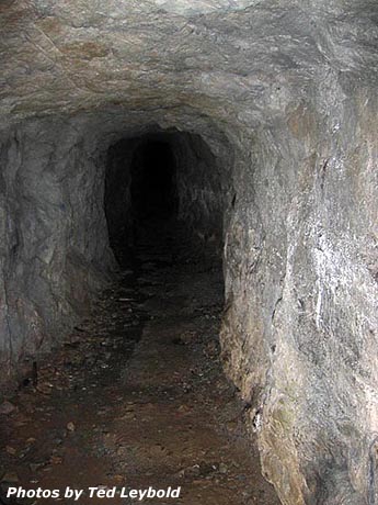
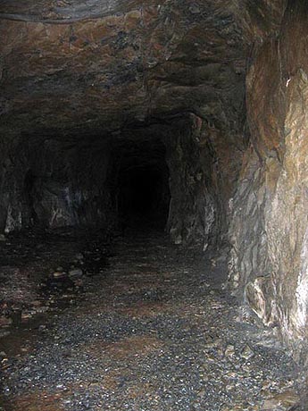
We booked it up the wide, flat trail just under 1 mile to the base of the falls. Right before we hit the end of the trail, the forest presented a gorgeous display of several species of flowers: trillium, avalanche lily, Oaks toothwort (?), and many other flowers that I’m far too incompetent to name. There were lots of interesting ferns, lichen and fungus as well. The waterfall itself was surprisingly impressive, rising 90 feet up a cliffside. An abandoned mineshaft was also located there, just to the right of the falls. We had brought headlamps to explore the inside, but we discovered a metal grate just a few yards inside the cave. Inside, however, we saw these amazing cave crickets clinging to the ceiling of the mineshaft. Cool!
DSCN0969.JPG
Henline Falls
DSCN0972.JPG
Cave crickets
We strolled back at a more moderate pace, enjoying good conversation and the fantastic scenery. We had both trails to ourselves today. And, most importantly, it didn’t rain on us. I was really impressed by what these trails had to offer. This was yet another fun day in the woods.
Will break trail for beer.

Blog and photos

User avatar
mayhem
Posts: 3579
Joined: December 22nd, 2009, 7:46 pm
Contact:

Re: Henline Mountain and Henline Falls 5/14/11

Post by mayhem » May 15th, 2011, 10:48 am

Thanks for sharing... I have never heard of either! Also it sure looks dangerous on those steep slopes with snow!
Shoe Shine Boy Has Left The Building!

User avatar
Splintercat
Posts: 8334
Joined: May 28th, 2008, 10:03 pm
Location: Portland
Contact:

Re: Henline Mountain and Henline Falls 5/14/11

Post by Splintercat » May 15th, 2011, 12:28 pm

Thanks - one of my favorite places! Henline Falls is looking very nice, too.
"...but we discovered a metal grate just a few yards inside the cave...."
That's new! Here are Silver King Mine photos taken on a trip to Henline in June 2007:

Image

Image

I can understand why this had to be gated off. It would be very easy for an unsupervised kid to wander in there.

-Tom

User avatar
retired jerry
Posts: 14424
Joined: May 28th, 2008, 10:03 pm

Re: Henline Mountain and Henline Falls 5/14/11

Post by retired jerry » May 15th, 2011, 2:46 pm

Poor Sue didn't know what she was getting into :)

Another adventurous trip

Ahhh... Fairy Slippers... I think I saw some on Nick Eaton Ridge

[email protected]
Posts: 250
Joined: May 28th, 2008, 10:03 pm

Re: Henline Mountain and Henline Falls 5/14/11

Post by [email protected] » May 15th, 2011, 3:30 pm

That trip report - thanks - it is great - sounds almost exactly like mine on the first time I tried to get up Henline. I remember rounding that curve and then what, that white stuff isn't supposed to be there and then trying and finally deciding just to head up and finding the trail again and up more. I've meant to get back there when the trail is all melted out but never done it so still don't know exactly where the trail goes. It is a good work-out for sure and lots of good look-outs along the way so thanks for putting this into the Portland Hikers information line since not too bad to drive there [and of course, going to the Falls is more than necessary]

User avatar
Crusak
Posts: 3617
Joined: August 6th, 2009, 7:33 pm
Location: Oregon

Re: Henline Mountain and Henline Falls 5/14/11

Post by Crusak » May 15th, 2011, 5:56 pm

Good report and exciting/adventurous-looking trip. The traverse along the steep rocks and snow does look a little dicey, but doable.
Jim's Hikes

Solvitur Ambulando

Post Reply