Greg and I went on a little autumn getaway to Florence last weekend and got in a few hikes. On Friday we hiked to Kentucky Falls. The hike isn't very long - about 4.5 miles roundtrip, I think - and it's a nice place to be in the fall.
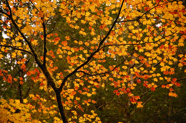
Well, a normal fall, anyway. As seems to be the case all over the northwest this fall, the colors were mediocre. There are places along this trail where there are huge swaths of vine maple. They were yellow, but they also looked sad and ill, like other vine maple I've seen this year. But here's one that looked pretty darn nice.
The water flow was REALLY low, of course. As such, I didn't even photograph the first waterfall, Upper Kentucky Falls. It was almost nothing more than a wet wall of rock.
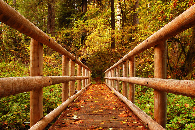
I loved this footbridge over the creek:
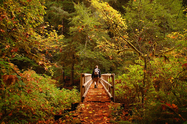
Here's Greg crossing the bridge:
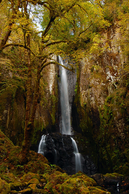
And then the waterfalls! For those of you who haven't been here before, there are two waterfalls within spitting distance of each other, and they're on two different creeks. North Fork Falls on the North Fork Smith River, and Lower Kentucky Falls on Kentucky Creek.
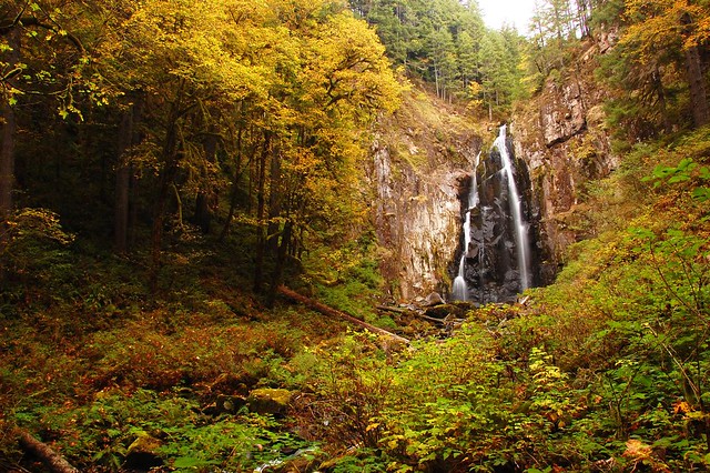
Here is Lower Kentucky Falls:
And North Fork Falls:
The weather forecast had been pretty dismal, and it did turn out to be a very GRAY weekend, but we did not get rained on during this hike, or on our hike to Sweet Creek the next day, so I was pretty dang grateful for that!
The only downside of this hike is that you lose elevation (800 feet) on the way in and gain it on the way out.
We plan to come back here in the spring when everything is nice and green and the waterfalls are flowing big.
Kentucky Falls - 10/22/10
-
- Posts: 3068
- Joined: May 28th, 2008, 10:03 pm
- Location: Portland, OR
- Contact:
Re: Kentucky Falls - 10/22/10
Hey, thanx for the report. I've wanted to do this hike for quite awhile but it's such a long drive for a daytrip. A couple quick questions;
How long did it take you from the time you left the freeway to get to the trailhead on the fs roads?
How were those roads?
And is there a connector trail across a creek that allows you to go onto the N Fork Smith River Trail and continue on a few more miles to a different trailhead?
How long did it take you from the time you left the freeway to get to the trailhead on the fs roads?
How were those roads?
And is there a connector trail across a creek that allows you to go onto the N Fork Smith River Trail and continue on a few more miles to a different trailhead?
Re: Kentucky Falls - 10/22/10
looks like a nice hiking trail to some pretty falls. I'll have to add that to my list of coastal day hike ideas, thanks for sharing.
-
- Posts: 3068
- Joined: May 28th, 2008, 10:03 pm
- Location: Portland, OR
- Contact:
Re: Kentucky Falls - 10/22/10
We came down Highway 99 from Greg's house in Corvallis, so we didn't come from the freeway. But from the time we left Highway 126 to the time we got to the trailhead, was probably about 30-45 minutes. The roads are actually in pretty great shape for FS roads. A few potholes here and there, but nothing bad.How long did it take you from the time you left the freeway to get to the trailhead on the fs roads?
How were those roads?
The trail we took to Lower Kentucky Falls connects right up with the trail along the North Fork Smith River. According to the map in William Sullivan's hiking book, that trail heads south along the river for about 6.5 miles to a trailhead along Road 23.And is there a connector trail across a creek that allows you to go onto the N Fork Smith River Trail and continue on a few more miles to a different trailhead?
- geographics
- Posts: 963
- Joined: August 5th, 2010, 2:11 pm
Re: Kentucky Falls - 10/22/10
.
Last edited by geographics on January 2nd, 2012, 12:00 am, edited 2 times in total.
Re: Kentucky Falls - 10/22/10
Really great photos! Thanks for posting. I've wanted to check this place out for awhile now as it's near my grandma's house.
- BrianEdwards
- Posts: 2405
- Joined: February 2nd, 2010, 1:32 am
- Location: Oregon City, OR
- Contact:
Re: Kentucky Falls - 10/22/10
Sweet shot of Lower Kentucky Falls, Cheryl.
Clackamas River Waterfall Project - 95 Documented, 18 to go.
-
- Posts: 3068
- Joined: May 28th, 2008, 10:03 pm
- Location: Portland, OR
- Contact:
Re: Kentucky Falls - 10/22/10
We stayed at the Old Town Inn, which is right by the Highway 101 bridge across the river. Surprisingly little traffic noise, though. It was conveniently located and very affordable, but not a dump by any means. I'd totally stay there again.Where did you stay?
We wanted to eat at the Waterfront Depot, since we had read nothing but rave reviews. We also read that it was a good idea to call ahead for a reservation, but when we called the day of, they said they were already totally booked! Yes, it was a Saturday, but it was also late October! Oh well. We had a fantastic dinner at the Bridgewater Restaurant, and we'll try again for the Depot next time we pass through there.
- geographics
- Posts: 963
- Joined: August 5th, 2010, 2:11 pm
Re: Kentucky Falls - 10/22/10
.
Last edited by geographics on January 2nd, 2012, 12:00 am, edited 1 time in total.
-
- Posts: 22
- Joined: October 14th, 2010, 9:11 am
Re: Kentucky Falls - 10/22/10
It may be a little late to post, but my wife and I started out from the Smith River trailhead a couple months ago to see the parts of the trail we'd never made it to before. The first part of the trail is very nice through some truly huge Douglas Firs, but after a couple miles, the trail got so overgrown that I'd want either a machete (at least) or a bulldozer to get through. We fought through about a half-mile of brush before giving up and turning around. Winter would probably be easier when the brush is less dense. Anyways, anyone attempting a through-hike should be prepared. I work at the Coffee shop under the bridge in Old Town Florence most weekends, so anyone in town looking for hiking ideas should stop by (also a good place to stop if the weather is too dodgy to enjoy hiking).