I was out for two nights last week on the east side of Mt. Jefferson. Before this trip, I had never seen a bear or a backcountry ranger in Oregon. Can you guess which one I finally saw?
Because of the extra driving time from Portland, I had never explored the eastern side of the wilderness. But much of the west side of the wilderness was closed (some has reopened since), so I drove over the crest and hiked to Table Lake and the Table from the Cabot Lake Trail.
The trail to Cabot Lake and Carl Lake was in great shape, unlike the other east-side trials (Sugarpine Ridge and Jefferson Lake Trails) that are reportedly abandoned. Beyond Carl Lake, there were sections of snow, but most of the trail was easily navigable. There was a brief section of trail prior to Table Lake that was completely under snow; the GPS came in handy here.
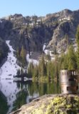
My first night was spent at the end of the trail beside Table Lake (my map showed a trail going beyond Table Lake, but apparently that is abandoned too):
The next day I hiked up the gully leading away from Table Lake and up to the Table. Here is a shot from the gully looking down at Table Lake:
I eventually made it to the lower Table (the northern half) and up to just below Goat Peak. From here, you could see the Cathedral Rocks (right side of picture) and numerous volcanoes in the distance:
I then crossed over to the upper Table (southern half of the Table). This was the most challenging part of the trip. I camped my second night up there.
Near campsite on the upper Table:
On the hike out, I encountered a friendly hunter. A few minutes after saying goodbye, I found this on the trail:
This left me with a bit of a dilemma because I generally leave stuff on the trail that I find if I believe that the owner will likely reclaim it. But what should I do with this beer cozy? It's not every day that you find a beer cozy that editorializes on forest management practices. In the end, I decided that I would probably just throw it out at home, so I left it for the hunter to enjoy on the way back down the trail.
Oh, and I finally saw my first bear in Oregon during this trip!
Details: This trip is about 20 miles out-and-back with 5,000 feet of elevation gain. This is really some stunning country with few signs of human activity. The stretch of the trail from Junction Lake to Table Lake has some lovely sub-alpine stretches around lava fields. And the Table (both upper and lower) is a wide-open, jaw-dropping pumice field.
The Table, Mt. Jefferson, Oct. 4-6
- cunningkeith
- Posts: 209
- Joined: June 26th, 2010, 4:28 am
- Location: Portland
- mattisnotfrench
- Posts: 1318
- Joined: May 28th, 2008, 10:03 pm
- Location: SE Portland
- Contact:
Re: The Table, Mt. Jefferson, Oct. 4-6
Awesome! This is a special place...and it's such a pain to get to it doesn't see a lot of people.
There is a trail past Table Lake, it just gets a bit confusing right as it leaves the lake. The ranger district left that sign there from a fire a few years ago. I asked them about it and they said the sign was a mistake and they'd go retrieve it...and yet, there it is. I don't get it. There's nothing wrong with the trail past the lake, other than it getting a bit vague for a hundred yards or so.
Author of Extraordinary Oregon!, PDX Hiking 365, 101 Hikes in the Majestic Mount Jefferson Region, and Off the Beaten Trail. Website: www.offthebeatentrailpdx.com
Re: The Table, Mt. Jefferson, Oct. 4-6
Great looking hike! I am coming into the area for a hike next week and I was curious where you got your GPS maps. I am looking for a good set to download! Thank you.
- cunningkeith
- Posts: 209
- Joined: June 26th, 2010, 4:28 am
- Location: Portland
Re: The Table, Mt. Jefferson, Oct. 4-6
Here's a report to the same area, but coming from the westtomb wrote:Great looking hike! I am coming into the area for a hike next week and I was curious where you got your GPS maps. I am looking for a good set to download! Thank you.
http://www.oregonhikers.org/forum/viewt ... =8&t=16562
This has the GPS track (thanks Brad!)
http://gpsfly.org/u/Born2BBrad/
If you're thinking about doing this hike next week, be prepared for a foot or two of snow (my guess) above around 5,000 feet.