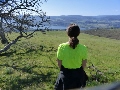
We got off to a late start on Monday. Not knowing if highway 22 was open due to the Whitewater fire, we took highway 20 along with about a bazillion other people. With traffic and some construction, we didn't arrive at the Lava Lake trailhead until around 10:45am. After finding a spot to park and last minute checks on packs and gear, we hit the trail at 11:00am. We decided to take the North Matthieu Lake trail to see the lakes and get the blood pumping. The trail was nice and had a couple decent inclines, some with switchbacks, others none. The North lake was pretty quiet. The views of what I believe to be Mt. Washington were obscured by smoke and haze. Snapped a few photos and proceeded to the south lake. Arriving there, we were surprised by the number of people. We met quite a few thru hikers, both NOBO and SOBO, and talked with them while having lunch. With lunch completed, we headed off. The Scotts Pass junction came up quickly and we began the loop. The weather was warm, a preview of the week to be, and we strolled at a decent pace. We came up on the Yapoah Lake trail and decided to take a look. The trail was ok at first then got very faint. After a search, we found the trail again and hit the lake. Nice little lake with what looked like a few decent camping spots. Again photos were taken and we went back to the main trail and continued on. The Green Lakes trail finally arrived and we turned south and began to stretch our strides. Our goal was Alder Creek or as close to as possible. The trail was nice and we began to enter the burn area. The trail started going back and forth between nice and very sandy. I haven't seen a trail like it before. I have walked on silty surfaces but this was like walking on the beach. We trudged on. Not knowing if the camping restrictions had been lifted, we kept our eyes out for possible camping spots that wouldn't affect the landscape. We soon came up on what I believe to be the notice boards with the burn area on them. They were blank. We discussed the possibilities. Were they removed by hikers, or were they taken down on purpose. Taking a few minutes, we scoured the ground looking for remnants of paper. Not finding any, we continued on. Finally the sweet sound of rushing water greeted our ears. Coming up around a bend we saw the creek. Looking around we noticed three tents already up so we decided to camp near the creek. After finding our spot, we set up camp and began the routine of washing up and making dinner. During dinner, thunder began to make its presence known. We kept our eyes open for any strikes but nothing came about. It rumbled for about 45 minutes then broke apart and the sky cleared. It was time for bed. Day 1 complete.
Morning of day 2 dawned clear and surprisingly chilly. We made our coffee and enjoyed the chill of the morning while making breakfast. With breakfast completed and another cup of coffee under our belts, we broke camp and began the days hike. The chill was quickly replaced with the days oncoming heat. The trail remained the same sandy surface for quite a while. The sun made its presence known very quickly. The heat rose rapidly. We came upon the Pole Creek trailhead and talked with some folks who were heading out. They had been to Camp Lake and had summited the Middle Sister. With congratulations and well wishes done, we headed to Soap Creek. Arriving there, we sat down to refill water and have some lunch. After lunch was eaten and water refilled, we continued on to the nights destination of Park Meadow. The sun was a cruel mistress. The day was hot and with very little cover it was a struggle. We came upon the the little pond/lake with no name and took a break. The bugs were out in force. Catching our breath and cooling down somewhat we moved on. Finally coming upon the notice board stating that we were leaving the burn area was great. Tree cover greeted us and we came upon a couple of streams that were clear and cold. More refills of water were necessary and we enjoyed the canopy cover. Pulling ourselves together, we moved out and finally arrived at Park Meadow. It seemed awfully quiet. We searched around and found a really nice camp and set up. Once again thunder made its presence known. although the clouds were much smaller than the previous night. Dinner and coffee were made and enjoyed with the sounds of the forest all around us. We never saw anyone that night. Dinner completed and feeling exhausted from the trail and the heat, we hit the sack.
Day 3 arrived almost like day 2. A nice chill in the air. Breakfast and coffee were made and plans for the day settled. We broke camp and headed for the Green Lakes for lunch. After a bit of walking, we came upon a trail heading east. Taking a guess that it might head to Golden Lake we took it for a side trip and pictures. We guessed right. Very scenic lake with what looked like to be some nice camping areas. Pictures taken and we headed back to the main trail and continued south. Soon enough we entered the pass. We came upon a couple of snow patches still on the trail. Nothing serious and easily navigated we moved on. Arriving at the summit of the pass, we took time to have snacks and enjoy the views. The skies were hazy still but we got some decent pictures. Beginning again, we headed down to Green Lakes for lunch. Finding a comfy and shady spot, we ate and watched other hikers coming and going. While not busy, there were quite a few folks out. Lunch done, we packed up and began again. The trail description written here was quite accurate. The are a number of junctions here and it is easy to get confused. We found our trail and moved on down to the Moraine Lake trailhead. Fall Creek was rushing and we came upon lots of people heading up to the lakes area. Finally arriving at the junction we stopped for another snack ( we like snacks
Morning of day 4 dawned clear and bright. Breakfast and coffee were served and we were off. While neither chilly nor warm, it was a perfect morning for hiking. We continued on and came to the Wickiup Plains. I really enjoyed the openness of them. I always have been a fan of open areas like that where you can see the trail in front and behind you. We traversed them while the sun began to heat the day. Making our way north, we decided to lunch at Mesa Creek and figure out the days plan to either stay on the PCT or take the side trails to the shelter and Linton Meadows. Arriving at the creek, we found a cool shady spot and ate. We decided on the shelter route. Lunch completed and we were off. We came upon the junction with thunder starting to be heard in the distance. Moving along smartly we encountered our first bugs since the little lake on day 2. Holy cow they were out in force! Moving along, they were pesky and a nuisance but when stopping for a breather or to take a drink, you were swarmed. It was rough. About half way to the shelter the rain started. It wasn't to heavy but the thunder was picking up. Continuing on, the rain picked up. We made a quick stop to cover our packs and moved on. The thunder continued its rumbling and we high tailed it for the shelter. Arriving there, we took shelter for a bit to see what the weather had in store. It decided to cooperate and everything broke up ( for now ). We headed out for the nights camping location in Linton Meadows. The trail was nice and easy and we made good time into the meadows and found a good spot. The bugs were there to greet us. While the mosquitos were not to bad, the black flies and no-see ums were terrible. Camp was quickly set up and dinner made. We ate in the tent to avoid the bugs. While not the best idea, it was the only escape. While eating, the thunder again made its way into our ears. Dinner finished and feeling tired, we retired early to just lounge in the tent and rest. Soon enough we realized that tonight the thunder was not going to go away. The rains started again slowly, then in earnest. Thunder bellowed and the first flash of lightening broke the growing darkness. The lightening began to flash more and more. We lay in our tent listening to the pelting rain. The flashes in the tent were bright and white. The storm rolled right over the top of us. While no meteorologist, I was counting Mississippi's between flashes and booms. We got to one. It was quite intense. Sleep came slowly, but with tired bodies we dozed off.
Morning came with partly overcast skies and the fresh smell of rain that makes you smile. We had breakfast and talked with another backpacker who was camped nearby about the storm. Breaking camp came quickly and the time came to go. The trail out of the meadows back to the PCT was quite a hump. We arrived at the junction to the PCT and headed north. The skies slowly cleared and the temps began to raise. The plan for the day was to get through the pass and then decide what to do when we hit Minnie Scott spring. The trail was nice and easy and we made good time through the Obsidian area. Stopping for water at Glacier Creek, the skies began to slowly start to grow cloudy. Picking up our pace, we finally began to ascend into the pass. Distant thunder increased our speed. We made it up and over the pass without any incidents. The views in the pass are really cool. The amount of lava rock and just the barrenness of the area was really enjoyable. Coming down off the pass we had to navigate a pretty good size snow field. While not treacherous, it was slushy and slick. With the springs just down the hill, we moved out. Coming down to the spring we were surprised by the amount of people. There was a group of about 10 heading up and into the pass, a Boy Scout group setting up camp nearby and numerous pairs of folk. We gathered out water and while looking at the clouds decided we would go ahead and make tracks for Lava Lake and finish our trip. We talked with the scout leader for a bit and a few thru hikers who were passing. We headed out. With our destination set, we moved at a quick pace. The thunderheads began forming just to the north of us and the rumbles increased our step. The trail was friendly and we moved quickly. The day went by and we finally got to the trailhead and our car.
The trip was a blast. I wish I could get my pictures to post, but after several attempts following the directions and trying to get photo bucket to work I gave up. I do have them posted on my Facebook page along with my wifes. Please feel free to check them out. Shane and Lynne Schaper
Thank you for your time in reading and I hope I don't discredit the group with poor writing. Next month we head to the Wallowa's to do the river loop again.