Marble Mountains, May 1-4
Posted: May 5th, 2016, 9:54 am
Ready to hit some backcountry that is really away from it all? The Marble Mountains fit the bill. I just spent three nights there and didn’t see anybody the entire time (save for a few dayhikers during the first few minutes); the place was empty and wondrous.
I drove to Lovers Camp on the east side of the wilderness just because it was the shortest drive (5:45 from Portland to the trailhead according to google) (my actual drive time was longer with breaks). I traversed most of the wilderness from east to west, starting at Lovers Camp and ending up at Cuddihy Lakes on the west. (15 miles, one-way)
The hike from Lovers Camp up the Canyon Creek Trail was snow-free until about 5,000 feet. By the time that I reached Little Marble Valley, the snow was about four-feet deep. Climbing up to the Marble Rim Trail was the biggest challenge.
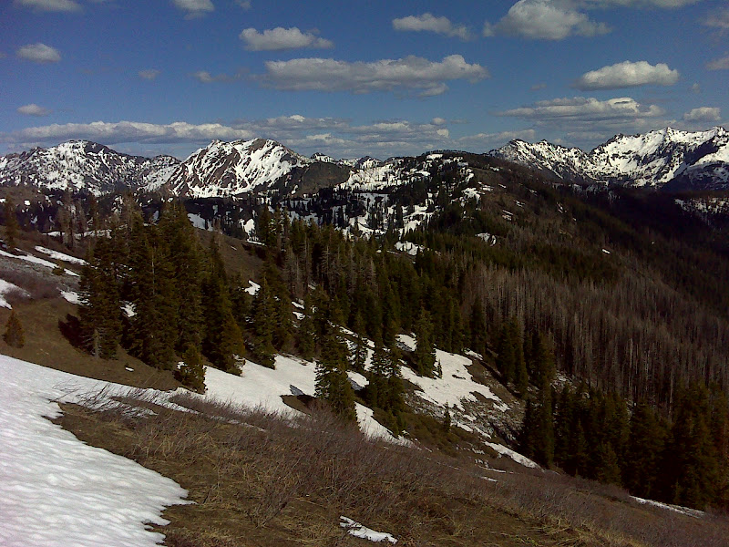
Here is a shot at the top of the ridge. It was great to reach a snow-free trail on the south side of the ridge.

Good view of Marble Mountain

The rest of the hike heads toward Spirit Lake and then to the Cuddihy Lakes. These trails are mostly south-facing and, therefore, were about 60-70% snow-free.
Looking south
There were some bear tracks along the way


And finally a bear (another one of my excellent wildlife shots!).

I reached Spirit Lake on the first night. Like a lot of the middle section of this hike, Spirit Lake is in a burn area, but not totally burned out. Two campsites were snow-free, which made for a much warmer night than having to camp on the snow.

Cool marble the next day on the way to Cuddihy Lakes

Cuddihy Lakes were lovely. I was glad that a few campsites had melted out.

Leading up to the trip, I had been watching the snowmelt progress and was confident that I would be hitting the Marbles at the very beginning of the snow-free backpacking season. As you can see from the pictures, this was more of a late-season snow-camp than an early season backpack.
The National Snow Analyses 3D Interface is super-cool and provides daily updates on the melt-out for anywhere in the U.S.
http://www.nohrsc.noaa.gov/earth/
Download the snow analysis overlay file and then open it on your computer (must have google earth). What I found, however, was the areas that were “snow-free” according to the analysis were still holding four feet of snow! So much for relying on technology. It made for more of an “adventure” than I had planned, especially since I had only packed my lite hikers for footwear.
For traction I only brought my Yaktrax, which really didn’t seem to help all that much in the slush.

Anybody have gear suggestions for better traction in the slush? I know it’s best to hike early morning after a freeze, but it didn’t freeze overnight and was mostly in the 60s during the day. This made for tough side-hilling. Other than that, though, this was a great trip to a stunning, out-of-the-way place.
P.S. The ranger at Fort Jones said that most of the cattle permits in the Marbles open for grazing on July 15, so get there before then!
I drove to Lovers Camp on the east side of the wilderness just because it was the shortest drive (5:45 from Portland to the trailhead according to google) (my actual drive time was longer with breaks). I traversed most of the wilderness from east to west, starting at Lovers Camp and ending up at Cuddihy Lakes on the west. (15 miles, one-way)
The hike from Lovers Camp up the Canyon Creek Trail was snow-free until about 5,000 feet. By the time that I reached Little Marble Valley, the snow was about four-feet deep. Climbing up to the Marble Rim Trail was the biggest challenge.
Here is a shot at the top of the ridge. It was great to reach a snow-free trail on the south side of the ridge.
Good view of Marble Mountain
The rest of the hike heads toward Spirit Lake and then to the Cuddihy Lakes. These trails are mostly south-facing and, therefore, were about 60-70% snow-free.
Looking south
There were some bear tracks along the way
And finally a bear (another one of my excellent wildlife shots!).
I reached Spirit Lake on the first night. Like a lot of the middle section of this hike, Spirit Lake is in a burn area, but not totally burned out. Two campsites were snow-free, which made for a much warmer night than having to camp on the snow.
Cool marble the next day on the way to Cuddihy Lakes
Cuddihy Lakes were lovely. I was glad that a few campsites had melted out.
Leading up to the trip, I had been watching the snowmelt progress and was confident that I would be hitting the Marbles at the very beginning of the snow-free backpacking season. As you can see from the pictures, this was more of a late-season snow-camp than an early season backpack.
The National Snow Analyses 3D Interface is super-cool and provides daily updates on the melt-out for anywhere in the U.S.
http://www.nohrsc.noaa.gov/earth/
Download the snow analysis overlay file and then open it on your computer (must have google earth). What I found, however, was the areas that were “snow-free” according to the analysis were still holding four feet of snow! So much for relying on technology. It made for more of an “adventure” than I had planned, especially since I had only packed my lite hikers for footwear.
For traction I only brought my Yaktrax, which really didn’t seem to help all that much in the slush.
Anybody have gear suggestions for better traction in the slush? I know it’s best to hike early morning after a freeze, but it didn’t freeze overnight and was mostly in the 60s during the day. This made for tough side-hilling. Other than that, though, this was a great trip to a stunning, out-of-the-way place.
P.S. The ranger at Fort Jones said that most of the cattle permits in the Marbles open for grazing on July 15, so get there before then!
