Mount Hood Climb - South/Pearly Gates Route - May 1st, 2016

This forum is used to share your experiences out on the trails.
User avatar
sergey
Posts: 9
Joined: February 24th, 2015, 7:51 pm
Location: Silicon Forest, OR
Contact:

Mount Hood Climb - South/Pearly Gates Route - May 1st, 2016

Post by sergey » May 1st, 2016, 10:04 pm

Mt. Hood was on my list of mountains to climb for a while. And despite that I climbed some higher cascade volcanoes (Shasta, Adams), Mt. Hood kind of scared me.
A week ago my friend invited me to join the climb (not the first time he invites me, but I always had some excuses not to go).
The weather forecast changed a bit during a week, and as for last Saturday it indicated clear, sky but windy - 30 mph. We decided to give it a try anyway.

Quick stats:
- Distance: about 8 miles round trip (this is not what is going to kill you)
- Elevation gain: 5250' (that might)

We started from Timberline at 2:00 am. Made it to the Silcox Hut at 2:55 am, took a small break, and continued to the top of Palmer and arrived there at 4:30 am, and took another break. It was very windy, but clear. The snow was firm. I made it to the top of Palmer without crampons, and decided to put them there.
Image


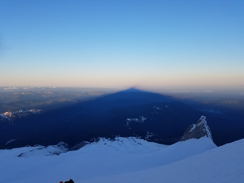
By 6:00am we were just under crater rock, and we've got to see a nice Mt. Hood shadow:
Image

And in 30 minutes we've got to Devil's Kitchen, where we took another break:
Image

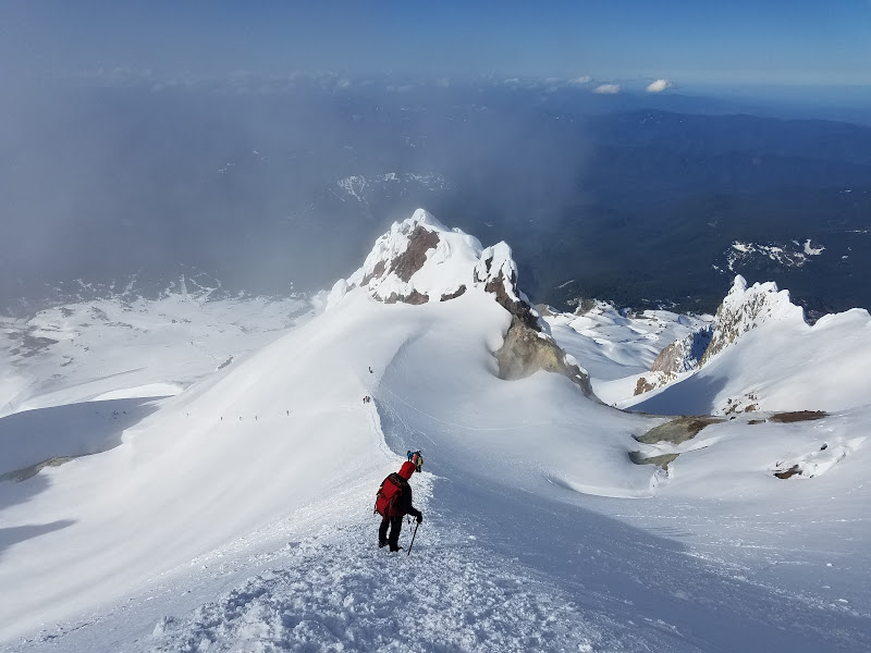
We kept going up, the wind gusts at the Hogsback were pretty strong. But wind died out as we approached Pearly Gates. Pearly Gates (we took the left one, looking at the mountain) had a steeper icy patch, about 30 ft long:
Image

The route from the top Pearly Gates to the summit was pretty easy. We summited at 8:00 am, so the way up took us about 6 hours, including breaks.
Image

Image

View to the volcanoes on Washington side: Mt. St. Helens, Mt. Rainier, and Mt. Adams:
Image

We spent about 20 minutes on the summit, taking pictures, having snacks, etc. And headed down.

Descending Hogsback:
Image

Looking down from Devil's Kitchen
Image

And looking up from the same spot:
Image

Going down, just below the Crater Rock. Gives an idea why in a whiteout conditions people end up going toward Mississippi Head:
Image

We arrived back at the parking lot at 11:30 am, so it took us just a bit more than 3 hours to descent the mountain.

Webfoot
Posts: 1765
Joined: November 25th, 2015, 11:06 am
Location: Troutdale

Re: Mount Hood Climb - South/Pearly Gates Route - May 1st, 2

Post by Webfoot » May 2nd, 2016, 5:37 pm

That looks amazing.

User avatar
Chip Down
Posts: 3043
Joined: November 8th, 2014, 8:41 pm

Re: Mount Hood Climb - South/Pearly Gates Route - May 1st, 2

Post by Chip Down » May 2nd, 2016, 6:03 pm

The big bare patch at DK intrigues me. I associate that sort of feature with the west side of the hogsback. I know for sure there's been one over there through the years, but don't recall seeing much to the east. Is my memory off? Anybody know?

I love the pic with broad-topped volcanoes on the horizon, and hood's little pointy snowcap, soon to melt off, in the foreground.

I'd like to try getting down from the summit in a whiteout, just to see how close I'd get. I know it's harder than it looks though. Even finding yourself in a whiteout below 8000' can be a little spooky.

When you returned to the parking lot, there were undoubtedly hikers just starting out. I hope you sneered at them and made them feel bad. ;)

User avatar
Arturo
Posts: 180
Joined: April 20th, 2015, 6:44 am
Location: Portland

Re: Mount Hood Climb - South/Pearly Gates Route - May 1st, 2

Post by Arturo » May 3rd, 2016, 6:47 am

Great point of view on the descent. Congrats.

User avatar
Water
Posts: 1356
Joined: May 28th, 2008, 10:03 pm

Re: Mount Hood Climb - South/Pearly Gates Route - May 1st, 2

Post by Water » May 3rd, 2016, 9:55 am

chip down, at least since i was first up there in 2009 DK has always had an exposed area of melt similar to hot rocks. I am curious though as it is at the top of While River Glacier if it helps to lubricate the glacier/keep a stream of water under it, etc.
Feel Free to Feel Free

User avatar
Koda
Posts: 3466
Joined: June 5th, 2009, 7:54 am

Re: Mount Hood Climb - South/Pearly Gates Route - May 1st, 2

Post by Koda » May 3rd, 2016, 10:24 am

Water wrote:I am curious though as it is at the top of While River Glacier if it helps to lubricate the glacier/keep a stream of water under it, etc.
yes, there is actually a small lake under the snow up there, in the summer there is an outlet stream that flows from the rocks. Guy has a picture and vid somewhere...
lightweight, cheap, strong... pick 2

User avatar
Chip Down
Posts: 3043
Joined: November 8th, 2014, 8:41 pm

Re: Mount Hood Climb - South/Pearly Gates Route - May 1st, 2

Post by Chip Down » May 3rd, 2016, 6:34 pm

How informative! I hope Guy sees this and contributes.

Very low on my bucket list (will probably never get to it) is standing on the top of crater rock. Probably not particularly difficult, but seems unwise.

Along those lines, I may have actually started up the St Helens dome once, but thought better of it and descended back into the crater. (Not admitting to it, because people here would freak out :D )

User avatar
retired jerry
Posts: 14424
Joined: May 28th, 2008, 10:03 pm

Re: Mount Hood Climb - South/Pearly Gates Route - May 1st, 2

Post by retired jerry » May 3rd, 2016, 7:44 pm

you were not on the dome inside the crater

were you????

actually, that seems pretty unstable. It would be a shame to get into trouble, then SAR would feel obliged to save you and risk themselves too

User avatar
sergey
Posts: 9
Joined: February 24th, 2015, 7:51 pm
Location: Silicon Forest, OR
Contact:

Re: Mount Hood Climb - South/Pearly Gates Route - May 1st, 2

Post by sergey » May 3rd, 2016, 11:40 pm

Chip Down wrote: I'd like to try getting down from the summit in a whiteout, just to see how close I'd get. I know it's harder than it looks though. Even finding yourself in a whiteout below 8000' can be a little spooky.
I did it on Mt. Adams once... good thing I had the track in my GPS (bad thing, I didn't look at the GPS too often). As I walked down to the false summit (presumably the way I came up), I spotted a 15 ft or so drop in front of me... I stopped, and thought to myself - I don't remember seeing anything like this on the way up. When I remembered that during the previous climb I explored that area and it was a crevasse at the east edge of the false summit... So I quickly pulled out my GPS and returned back to the route...

Ah, and here is the view at the summit that day:
Image
Chip Down wrote: When you returned to the parking lot, there were undoubtedly hikers just starting out. I hope you sneered at them and made them feel bad. ;)
I just assumed they were walking around the Timberline lodge... although it was a guy with a pair of skis asking me if it is possible to ski down all the way from the summit...

User avatar
sergey
Posts: 9
Joined: February 24th, 2015, 7:51 pm
Location: Silicon Forest, OR
Contact:

Re: Mount Hood Climb - South/Pearly Gates Route - May 1st, 2

Post by sergey » May 3rd, 2016, 11:42 pm

retired jerry wrote:you were not on the dome inside the crater

were you????
Me?! I don't think so...

Post Reply