I'd never been to Canyon Creek Meadows before, so I thought I ought to check it out before the flowers got cooked this summer. My plan was to do an 8-mile loop described in Douglas Lorain's
100 Classic Hikes in Oregon: up to Canyon Creek Meadows from Jack Lake, then up the moraine above the little lake, then up to the saddle between Three-Fingered Jack's summit and its east ridge, then down to First Creek Meadows; from there you bushwhack down to Trail #4014, which takes you back to Jack Lake. I figured I may as well get two meadows for the price of one, and who doesn't like a loop?
Well, let me say this right away before I get to the photos:
DON'T DO IT. At least, not the full loop that I did. First Creek Meadows weren't very impressive — and definitely not worth the 1/2-mile scree/talus descent, 1-mile bushwhack over burnt deadfall, and then 2.5 miles of unshaded dusty trail. (I think it must have been a hell of a lot better before the 2003 fire.) But, on the bright side,
TFJ's east ridge was really fun.
Okay, anyway... I drove up to the Jack Lake Trailhead the night before and spent the night at one of the handful of unadvertised campsites near the parking lot. My site even had a picnic table, and inquisitive neighbors:
I woke up at about 5:00 and watched the sunrise light on 3FJ:
After breakfast, I got going about 6:40; I took the northern trail to Canyon Creek Meadows. The first mile was boring, but then I started encountering the creek and all its morning mosquitos. But there were finally some flowers:
I didn't get many views of Three-Fingered Jack until the junction with the southern leg of the usual loop, at about 5500'. The long early-morning shadows cast by the local trees were getting in the way of my meadow photos:
The lupines in the vicinity of the loop junction were mostly going to seed already. I was starting to think CCM was a bit of a bust, until I hiked another 3/4 mile beyond the "Trail Not Maintained" sign to the upper meadows at 5800'. There, the lupines were at their peak, and the views were unobstructed:
The little rivulets running through the meadow were all dry, so it was easy to use them as paths to walk through the lupine fields without stomping anything. Over on the hilside near the unofficial trail, the magenta paintbrush and partridgefoot were looking good:
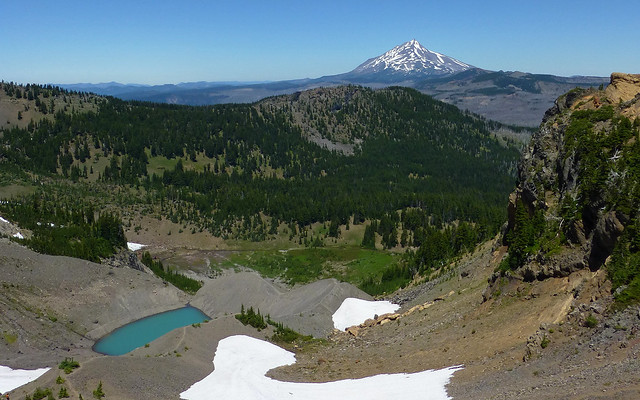
Then I hiked up the moraine to the little pond/lake formed by TFJ's snowmelt. All the photos I'd seen online showed an amazingly blue pool of water, but apparently that's just its early-season color, because it was a little more drab today. The view of Mt. Jefferson was pretty nice, though:
I kept going up. From the saddle above the lake, just below Jack's summit, there was a great view to the south, of Broken Top, the Three Sisters, and Mt. Washington (not pictured because I ran out of attachments!).
And I was eyeing that funky red-and-yellow ridge that sits above the saddle to the east. I'd noticed it before when I'd visited the south ridge, and wondered whether it was explorable; it
looks pretty scary from the south. But from the saddle, the left side looks like a possibility:
I saw some boot paths on the north side of the east ridge, so I wandered over there. It was a cool volcanic landscape full of red and yellow cinders sprinkled with improbably placed wildflowers. Looking south toward the top of the ridge, I saw a couple of possible routes; the red line shows the path I ended up taking:
As I got closer, those big rock formations loomed large and looked even weirder. And I noticed a ton of wildflowers — mostly arnica — growing in the scree right at the base of that thick yellow layer.
I was able to scramble to the top of the ridge, and then over to within a few feet of the top of that big yellow hoodoo at the end. This is looking down into the gap next to it:
I finally pulled myself away from the cool rocks on the ridge and went back down to the saddle, then down into First Creek's valley. Unlike the climb UP to the saddle, there were no distinct paths leading down the other side. It started as loose dirt and scree, then became talus; the unpleasant rocky descent covered a full half mile, before I got to anything resembling a "meadow":
Finally, after picking my way over boulders and squeezing through some small hemlocks, I arrived at First Creek Meadows. They were okay, I guess, but much drier than Canyon Creek Meadows (maybe because the watershed faces southwest?), and I wasn't exactly blown away. There were a few nice patches of arnica, though:
And then it was time to bushwhack my way down to the actual trail, which was another mile downhill. Unfortunately, the ground is littered with dead, burnt trees, many with their pointy dead branches still attached, and those are no fun to negotiate. I stayed close to First Creek and got a couple of flower photos, but everything is so sun-baked after the fire that the creek and its erstwhile tributaries are only shadows of their former selves. Kinda like this big circle of grass — which should have been a tarn, according to the topo map:
I finally reached the trail and found that it had its share of deadfall too. The entire 2.5 miles back to Jack Lake was through a shade-free manzanita/snowbrush wasteland full of burnt, broken snags. There really wasn't much of anything to see:
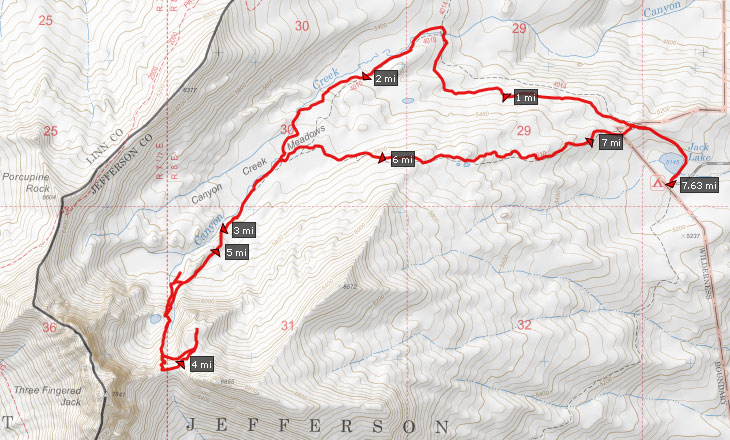
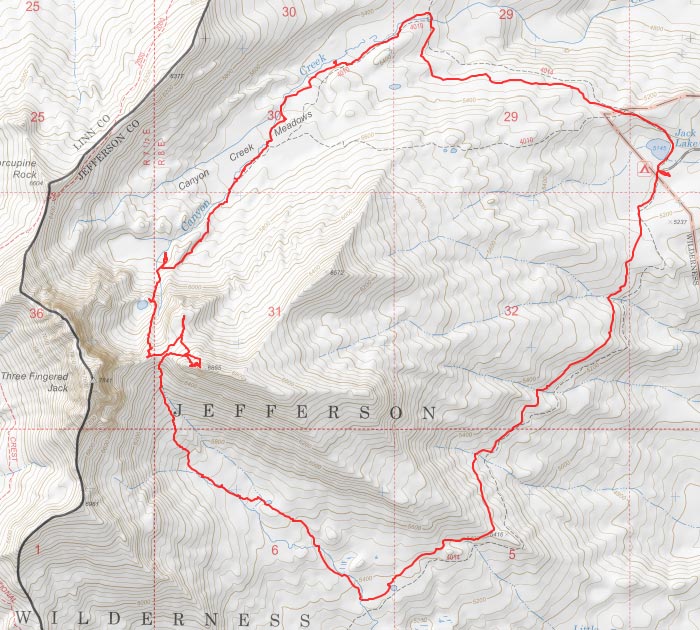
My full route:
So, in conclusion: by all means, go to Jack Lake and hike to Canyon Creek Meadows. Climb up the moraine and look down on the little brown (or blue) lake. Keep going up to the saddle and enjoy the big views to the south. Explore the cool east ridge with all its volcanic guts laid bare. But afterwards, just go back down the north side of the ridge and take the other leg of the CCM loop back to your car!