That's not good. Once these places close they tend to stay that way until the bad weather starts. This could ruin a lot of fall hiking too.
KATU reported that the fire had spread to the Cathedral Ridge / Mazama Trail area yesterday.
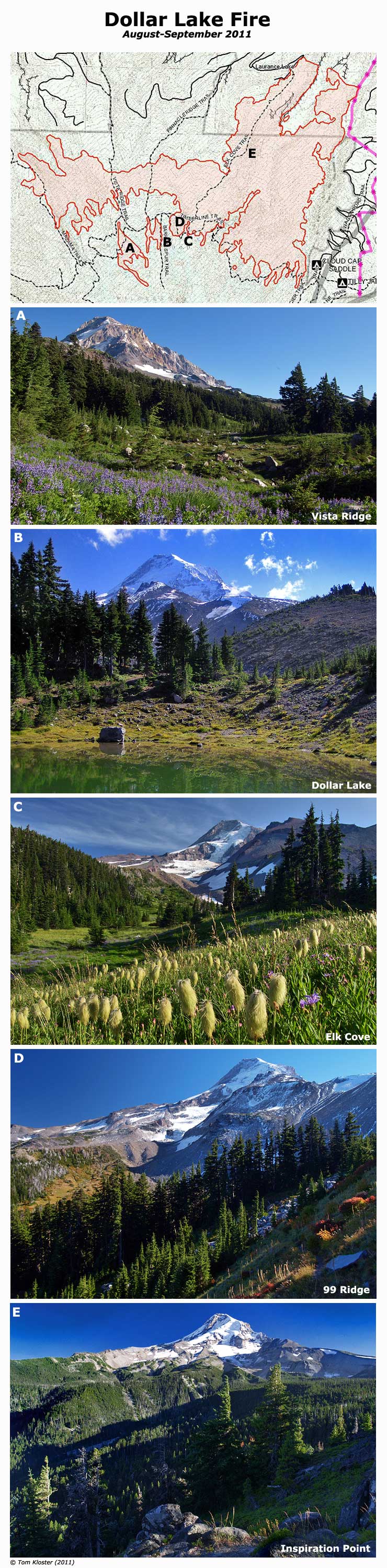
Dollar Lake Fire
-
retired jerry

- Posts: 14424
- Joined: May 28th, 2008, 10:03 pm
Re: Dollar Lake Fire
It'll be interesting to go up there and check it out next spring
-
Grannyhiker

- Posts: 4598
- Joined: May 28th, 2008, 10:03 pm
- Location: Gateway to the Columbia Gorge
Re: Dollar Lake Fire
Map of approximate area actually burned as of 6 am today: https://inciweb.nwcg.gov/ftp/InciWeb/OR ... 522-0.jpeg
-
adamschneider

- Posts: 3716
- Joined: May 28th, 2008, 10:02 pm
- Location: SE Portland
- Contact:
Re: Dollar Lake Fire
Close-up of this morning's map:

-
adamschneider
- Posts: 3716
- Joined: May 28th, 2008, 10:02 pm
- Location: SE Portland
- Contact:
Re: Dollar Lake Fire
Interactive map of the latest fire perimeter: http://tinyurl.com/dlfire-9-4
-
Grannyhiker
- Posts: 4598
- Joined: May 28th, 2008, 10:03 pm
- Location: Gateway to the Columbia Gorge
Re: Dollar Lake Fire
Thank you very much, Adam, for putting this on a real map!
-
Splintercat

- Posts: 8334
- Joined: May 28th, 2008, 10:03 pm
- Location: Portland
- Contact:
Re: Dollar Lake Fire
This is sort of a jumbo image, but I put this together to put a "face" on the rather dry info shown on the maps -- I'm anxious to see how much has changed up there, too. I'm having flashbacks to 1980, and how it felt to lose Spirit Lake, Harmony Falls and Mt. St. Helens in one massive sweep. Obviously, this is much less dramatic, but I won't live long enough to see the big trees return if the alpine groves along the Timberline Trail have burned.
Part of the natural process, of course, and the starkness of a recovering burn has its own beauty... but hard to adjust to, nonetheless.
-Tom
Part of the natural process, of course, and the starkness of a recovering burn has its own beauty... but hard to adjust to, nonetheless.
-Tom

Re: Dollar Lake Fire
Absolutely stunning pictures, Tom.
This fire makes me sad. I know it's a part of the natural process, but the north side of Hood is one of my favorite places in the world.
That said, there is a different, stark beauty to a burned landscape. I was just in the Jefferson wilderness this week, and it was my first time hiking through an extensive burn area. The B&B complex really torched that area.
___________________________
Trail Log: http://myroadstraveled.blogspot.com/
Trail Log: http://myroadstraveled.blogspot.com/
-
retired jerry
- Posts: 14424
- Joined: May 28th, 2008, 10:03 pm
Re: Dollar Lake Fire
Walking from Tilly Jane to Cloudcap a year ago:
East of the South Sister in 2008:
Mill Creek area in Ochocos in 2009:
-
pdxflowergirl
- Posts: 589
- Joined: March 6th, 2009, 12:47 pm
- Location: Portland, Oregon
- Contact:
Re: Dollar Lake Fire
After seeing the smokey haze on our approach from the east around 8am, I immediately looked on PH.org and saw this discussion thread. Funny that my first impulse wasn't to look on local news site!
Snapped pic this morning from the Empire Builder train returning from Glacier National Park (somewhere between White Salmon and Stevenson) where Mt. Hood looked like a Cascade island in the sky. This is what happens when I leave Oregon for a week...
Snapped pic this morning from the Empire Builder train returning from Glacier National Park (somewhere between White Salmon and Stevenson) where Mt. Hood looked like a Cascade island in the sky. This is what happens when I leave Oregon for a week...
Kam