I plan to hike as many of the abandoned trails within and around the Indian Heaven Wilderness area of the Gifford Pinchot Forest that I can between now and the end of next summer.
In the process of this, I'm looking for old maps or GPS tracks that anyone may have for any of these trails and perhaps any recent trail reports.
I do have several pictures of NatGeo TOPO! maps provided on the field guide portion of this main site.
My plan is to hike them all and GPS track them and enjoy the adventure of it all.
Any help is appreciated!
The current list of trails I have found from searching:
*CCT (There are several sections of this I'd like to explore)
*Acker Loop
*Gifford Peak Trail (Basin Lakes)
*Chenamus Lake Trail
*Pack Trail (I cannot find any info on this trail)
*Bear Lake Cut off to Lemei Trail
*Lemei Trail Loop to Wapiki Lake
*Old Indian Race Track
*Maybe other I forgot or haven't mentioned.
Indian Heaven Wilderness Trails
Indian Heaven Wilderness Trails
Last edited by Mikeph4 on September 21st, 2016, 6:24 am, edited 1 time in total.
Re: Indian Heaven Wilderness Trails
These resources may help:
http://ngmdb.usgs.gov/maps/TopoView/viewer/
http://earthexplorer.usgs.gov/
For example for Red Mountain just south of Indian Heaven:
a 1957 15 minute topo: http://ngmdb.usgs.gov/ht-bin/tv_download.pl?id=5410912
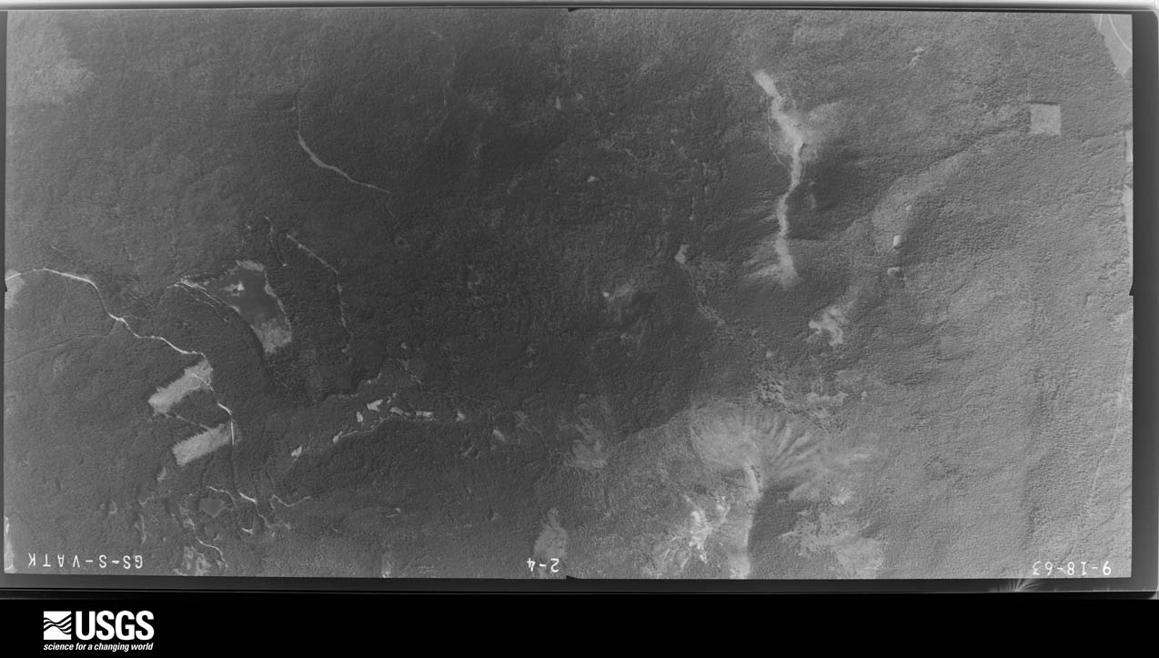
a 1963 aerial photo: http://earthexplorer.usgs.gov/browse/ai ... 41_008.jpg
http://ngmdb.usgs.gov/maps/TopoView/viewer/
http://earthexplorer.usgs.gov/
For example for Red Mountain just south of Indian Heaven:
a 1957 15 minute topo: http://ngmdb.usgs.gov/ht-bin/tv_download.pl?id=5410912
a 1963 aerial photo: http://earthexplorer.usgs.gov/browse/ai ... 41_008.jpg
Re: Indian Heaven Wilderness Trails
Awesome info. Don't know how I managed to never find the map portion of the USGS site.
This definitely helps a lot.
This definitely helps a lot.
-
Don Nelsen

- Posts: 4381
- Joined: May 28th, 2008, 10:03 pm
- Location: Vancouver, WA
Re: Indian Heaven Wilderness Trails
Here is a track from a hike I did on July 3 this year to Gifford Peak. Two of us had GPS's and so there are two tracks here but mostly they overlap. The trail is difficult in places to follow, but with some care you can figure it out. Have fun! dn

"Everything works in the planning stage" - Kelly
"If you don't do it this year, you will be one year older when you do" - Warren Miller
"If you don't do it this year, you will be one year older when you do" - Warren Miller
Re: Indian Heaven Wilderness Trails
Do you have the GPS data to go with this by chance? So I can import it to my GPS for ease. Thanks for the report though.Don Nelsen wrote:Here is a track from a hike I did on July 3 this year to Gifford Peak. Two of us had GPS's and so there are two tracks here but mostly they overlap. The trail is difficult in places to follow, but with some care you can figure it out. Have fun! dn
-
Don Nelsen
- Posts: 4381
- Joined: May 28th, 2008, 10:03 pm
- Location: Vancouver, WA
Re: Indian Heaven Wilderness Trails
[quote="Mikeph4g]
Do you have the GPS data to go with this by chance? So I can import it to my GPS for ease. Thanks for the report though.[/quote]
I have it in NG Topo only but I will be happy to send it if you will send me a PM with your E-mail address. The track is a little jumbled since we merged two GPS units but it's a good track you can upload to your GPS through topo.
-Don
"Everything works in the planning stage" - Kelly
"If you don't do it this year, you will be one year older when you do" - Warren Miller
"If you don't do it this year, you will be one year older when you do" - Warren Miller
-
sprengers4jc

- Posts: 1036
- Joined: October 22nd, 2013, 11:35 am
- Location: Vancouver, WA
Re: Indian Heaven Wilderness Trails
Searching gpsfly.org should give you a bunch of ideas, too. Be forewarned, though: many of the topo maps I have seen screw up Indian Heaven. Here is a hi-res scan of Mel Hansen's map from the 70s, which shows many of the abandoned trails. Though it is lacking in detail, it should give you a good overview of what you will find up there.
- Attachments
-
'We travel not to escape life but for life to not escape us.'
-Unknown
-Unknown
Re: Indian Heaven Wilderness Trails
I have seen this map before. It's been helpful somewhat. I've come across a few other maps now that are very detailed. And Don was able to provide some very helpful GPS tracks. Otherwise most maps don't show all the trails that I'm looking for.sprengers4jc wrote:Searching gpsfly.org should give you a bunch of ideas, too. Be forewarned, though: many of the topo maps I have seen screw up Indian Heaven. Here is a hi-res scan of Mel Hansen's map from the 70s, which shows many of the abandoned trails. Though it is lacking in detail, it should give you a good overview of what you will find up there.
I made it out there this weekend, only to unfortunately cut the trip short due to the wife being very sick. So I wasn't able to hike any trails with her.
We are aiming for a trip in the next couple weeks again if the weather holds up. Otherwise, it'll be waiting for next summer. At that point I will be making a new map with GPS tracks of all the abandoned trails and their conditions. I've also come across many trails that appear to have never existed, as there is no information on them, even though it's obvious many have been traveled often in the past and certainly aren't animal trails.

Re: Indian Heaven Wilderness Trails
Mikeph4 wrote:I plan to hike as many of the abandoned trails within and around the Indian Heaven Wilderness area of the Gifford Pinchot Forest that I can between now and the end of next summer.
In the process of this, I'm looking for old maps or GPS tracks that anyone may have for any of these trails and perhaps any recent trail reports.
I do have several pictures of NatGeo TOPO! maps provided on the field guide portion of this main site.
My plan is to hike them all and GPS track them and enjoy the adventure of it all.
Any help is appreciated!
The current list of trails I have found from searching:
*CCT (There are several sections of this I'd like to explore)
*Acker Loop
*Gifford Peak Trail (Basin Lakes)
*Chenamus Lake Trail
*Pack Trail (I cannot find any info on this trail)
*Bear Lake Cut off to Lemei Trail
*Lemei Trail Loop to Wapiki Lake
*Old Indian Race Track
*Maybe other I forgot or haven't mentioned.

The above map shows the on-trail & off-trail wanderings that I did in Indian Heaven over several years. I have a gpx file for all of the above but it's bigger than 1 MB (this site's limit) so if you PM me an email address, I'll be happy to send it to you.
I think "pack trail" is just the USGS generic designation for any trail otherwise not numbered or named - very common on provisional maps.

Re: Indian Heaven Wilderness Trails
I happened to come into contact with that GPX, and made this from it: http://caltopo.com/m/KSLRVanMarmot wrote:The above map shows the on-trail & off-trail wanderings that I did in Indian Heaven over several years. I have a gpx file for all of the above but it's bigger than 1 MB (this site's limit) so if you PM me an email address, I'll be happy to send it to you.
And since it eliminated overlapping segments, the exported GPX is only 680KB, too.
(Hope you approve?)
Karl
Back on the trail, again...
Back on the trail, again...