A sunny day on Blue Lake Ridge

Discussions and Trip Reports for off-trail adventures and rediscovering lost trails
Post Reply
User avatar
K.Wagner
Posts: 652
Joined: June 2nd, 2013, 1:25 pm
Location: Vancouver, WA

A sunny day on Blue Lake Ridge

Post by K.Wagner » November 11th, 2016, 11:50 am

It is likely that few of the Oregon Folks have ever heard of Blue Lake Ridge, so first to locate it. If you were to drive Hwy 12 (the White Pass Hwy), through Randle, and could drive about 10 miles east and then could jump into a waiting helicopter and fly about 13 miles south you would be there. If on the way, you were to fly a few miles farther south, and look north, this is what you would see:
Blue_Lake_Ridge.jpg
Not so impressive, but Mt Rainier hiding in the clouds off on the right side does give a hint at the scenery.

So, the back story...... I am currently working on an “on call” basis. So of course, when I start to make plans, I get called in. That's just the way life works. So this last call sounded like it was just going to be a one day thing. I loaded up the back of my truck with all the essentials, and went to work with the plan of leaving work and heading north to spend the night, and then have fun the next day, which was forecast to be really nice. Finally at quiting time, the boss, rather apologetically said: “Kelly, I don't think we will need you tomorrow...”. I laughed and explained that I was hoping he would say that, and that my truck was loaded, ready to head for the hills tonight. His jaw dropped several inches. I left Clackamas at 4:00, and finally at 8:30 rolled into the Cat Creek CG on FR 21 (having had to get there the long way because of road damage on FR23.) By 8:45 I was in the sack, and probably was asleep by 8:50.

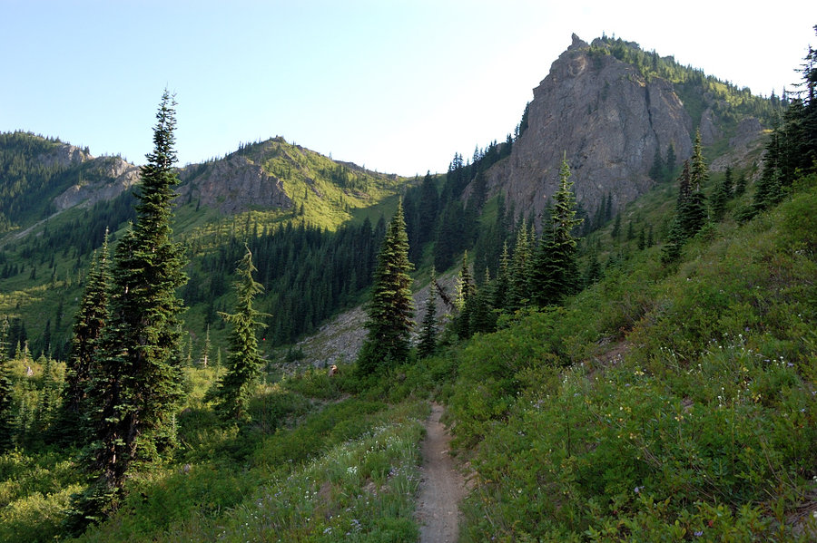
A short drive up FR78, then up the unknown conditon FR7812. I had seen a clear swatch up the slope on the satellite views 6 1/4 miles up, that looked like it would make a fun route, but you never know until your boots are on the ground. The road was in reasonably good shape, and along the way, got this view over across the Dark Divide:
02-Jumbo & Sunrise & Spud Hill-S.jpg
[left to right, Jumbo; 2860 (near, low foreground); Sofibia (bare rock, barely visible); Sunrise Peak; Spud Hill (big forested hump); Juniper Peak (far right, bare)]
After a few more fairly easy miles, there it was, and it would work!
06-Start of route-S.jpg
Before I started, I looked at my thermometer. 52 degrees! Unheard of! So up I went. Couldn't help but think as I was working my way through the rocks and bear grass: “I bet this was really pretty a couple of months ago!”. Here's a shot looking back down, what a view!:
07-Looking down-S.jpg
I had seen a second clearing, perhaps 200 yards upslope of the lower clearing, but again, had no idea what to expect. When I came out of the trees, there it was, and it would go!
08-Second clearing-S.jpg
Again, as I was walking along the ridges through all the bear grass, couldn't help but think: “I bet this was really pretty a couple of months ago!”.
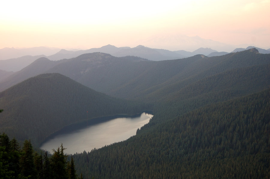
Up through more open timber, and then I walked over the crest of the ridge, where I got this view, that's Blue Lake down below:
17-at 5400 ft, view N-S.jpg
In front of me was about 200 feet of sheer cliff, so stayed pretty well back from the edge. I won't bore you with all the names, expect that just to the right of Mt Rainier is Hamilton Buttes.

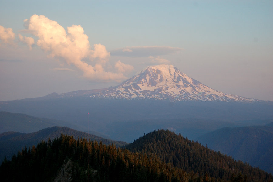
A little farther up, this view of Goat Rocks opened up:
22-Goat Rocks-S.jpg
Then about 200 more feet of climbing, mostly on an elk trail, got me to the summit. I didn't take a picture of it, but the little summit meadow looked like it was an elk bedding area. I think that those big critters enjoy the big views as much as us lowly humans do.

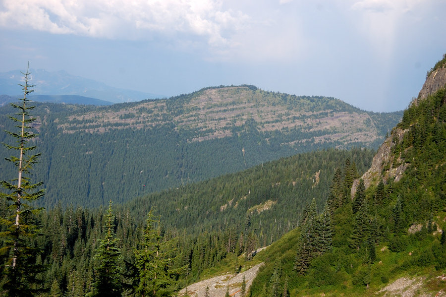
Looking NE again at Peak 5700 near Hamilton Buttes (a fun scramble) This one is interesting, because the entire eastern slope is bare, as you see in this picture:
32-5700-S.jpg
Looking ENE at the Goat Rocks again:
31-Goat Rocks-S.jpg
Looking SE at Mt Adams. Notice the lenticulars floating to the north of the mountain.
25-Mt Adams-S.jpg
The wind was blowing pretty good, so after a quick summit snack I headed down. As I was hiking down through the upper clearing, I happened to look up, and saw the source of the debris ridge that I was on. A huge cliff was just upslope. This poor ridge has endured several major collapses!

I stopped in the Cowlitz Ranger Station on the way back to talk to them about the road repair projects. The engineer was out in the field, and the gals at the front desk didn't have much info, except that FR23 & FR 29 are scheduled to be reopened by September 2017. I am going to write a letter to the engineer, and will post his reply.

Final numbers for the day, about 2 1/2 miles with about 1,200 feet of gain and amazing views!

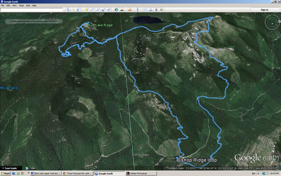
Here is a map link: Blue Lake Ridge The clearing I went up is just above the 7812 tag, and the second clearing can be seen upslope.
Kelly
There is no shortcut to anyplace worth going to.

PM me about the soon to be released:
Skamania 231
"How to really get off the beaten path in Skamania County"

User avatar
K.Wagner
Posts: 652
Joined: June 2nd, 2013, 1:25 pm
Location: Vancouver, WA

Re: A sunny day on Blue Lake Ridge

Post by K.Wagner » November 11th, 2016, 1:46 pm

Ah, Romann,

I know you have been on this summit, what route did you use?
Kelly
There is no shortcut to anyplace worth going to.

PM me about the soon to be released:
Skamania 231
"How to really get off the beaten path in Skamania County"

pablo
Posts: 1451
Joined: May 28th, 2008, 10:03 pm

Re: A sunny day on Blue Lake Ridge

Post by pablo » November 11th, 2016, 4:21 pm

Nice report, thx, I think I see how you got there from looking at Google Earth. Never been there - that ridge to the east of Blue Lake looks like fun and there is trail next to it. I'll have to add this area to my list.

--Paul
The future's uncertain and the end is always near.

User avatar
K.Wagner
Posts: 652
Joined: June 2nd, 2013, 1:25 pm
Location: Vancouver, WA

Re: A sunny day on Blue Lake Ridge

Post by K.Wagner » November 11th, 2016, 5:17 pm

pablo,

I think that you are looking at the Hamilton Buttes / 5700 ridge, which show up in that first Mt Rainier view. Normally, you can drive up to Mud Lake via FR7807, and start there. However, with the massive road damage that happened last winter, FR78 is damaged at both ends (this is the southern damage):
40-FR7800-S.jpg
Cat Creek just decided to take a different route here. You can see the old channel to the right.

So, you can't get to that end of FR7807, and the SE end of it is really torn up too. Now, your only option is start down by Cat Creek CG at about 3,300 feet.

5700 is a fun scramble from the trail, and Hamilton Buttes has a trail (read: now abandoned road) to the summit.

The peaks to the north, also seen in the first view shot are pretty impressive too.
Kelly
There is no shortcut to anyplace worth going to.

PM me about the soon to be released:
Skamania 231
"How to really get off the beaten path in Skamania County"

User avatar
Splintercat
Posts: 8334
Joined: May 28th, 2008, 10:03 pm
Location: Portland
Contact:

Re: A sunny day on Blue Lake Ridge

Post by Splintercat » November 14th, 2016, 12:27 pm

Great report & photos, Kelly! Thanks for posting!

Tom :)

User avatar
Sean Thomas
Posts: 1647
Joined: February 25th, 2012, 11:33 pm

Re: A sunny day on Blue Lake Ridge

Post by Sean Thomas » January 6th, 2017, 10:43 pm

Awesome report Kelly! I've always wondered about that ridge when viewing it from various other peaks in the area. Too bad about the 78 road, driving up to Mud Lake and making the quick hike up to the buttes was always a favorite of mine.

User avatar
K.Wagner
Posts: 652
Joined: June 2nd, 2013, 1:25 pm
Location: Vancouver, WA

Re: A sunny day on Blue Lake Ridge

Post by K.Wagner » January 7th, 2017, 9:51 pm

Sean,

Seems like I haven't seen your name on here for a long time now!

Have you seen my road repair listing for the Cowlitz Valley RD on the General Hiking Topics forum? The 78 road is hopefully scheduled for repair this coming fall.
Kelly
There is no shortcut to anyplace worth going to.

PM me about the soon to be released:
Skamania 231
"How to really get off the beaten path in Skamania County"

User avatar
romann
Posts: 2417
Joined: May 28th, 2008, 10:03 pm
Location: Vancouver, WA

Re: A sunny day on Blue Lake Ridge

Post by romann » January 12th, 2017, 10:47 pm

Missed your trip report, Kelly. You found very cool approach, more of an open scramble with views - avalanche chute? - as opposed to bushwhackier east side ascent (not bad brush really, but more than most places around here). Great views of Rainier and Adams from the top. Did you see more Mtn Goat fur around the summit? BTW trail along east side doesn't correspond with map at all; on the descent I lost too much time trying to locate non-existent trail in the dark and just camped near the first water hole (but I was going to camp further in the loop anyway).
Image

Had smoky view of Raininer above Blue Lake
Image

Adams to the south
Image
pablo wrote:that ridge to the east of Blue Lake looks like fun and there is trail next to it. I'll have to add this area to my list
According to trail signs in the area, it's named Bishop Ridge - it's really nice indeed
Image

User avatar
K.Wagner
Posts: 652
Joined: June 2nd, 2013, 1:25 pm
Location: Vancouver, WA

Re: A sunny day on Blue Lake Ridge

Post by K.Wagner » January 13th, 2017, 2:21 pm

Roman,

I think that the open "basin" than I used was a slide chute from a cliff fracture near the crest of the ridge.

I thought that Bishop Ridge was the ridge to the north of Hamilton Butte.
Kelly
There is no shortcut to anyplace worth going to.

PM me about the soon to be released:
Skamania 231
"How to really get off the beaten path in Skamania County"

User avatar
romann
Posts: 2417
Joined: May 28th, 2008, 10:03 pm
Location: Vancouver, WA

Re: A sunny day on Blue Lake Ridge

Post by romann » January 13th, 2017, 8:54 pm

Yes hard to tell now because I didn't save pictures of trail signs from the trip. But there was "Bishop Ridge Trail" or something and I recall reading it at/before the pass, as I was leaving Blue Lake basin. Maybe that trail continues to the next ridge with this name... Google Earth labels the ridge to the north of Hamilton Butte as "Cozy Ridge" but don't see it named on the maps.

Sooner or later I just have to explore up there, very unusual geology!
Image

Post Reply