Three Ways to Wygant

Discussions and Trip Reports for off-trail adventures and rediscovering lost trails
mandrake
Posts: 389
Joined: May 28th, 2008, 10:03 pm
Location: Portland, OR

Re: Three Ways to Wygant

Post by mandrake » March 6th, 2016, 9:29 pm

Returning to Wygant Peak (a good rainy day destination) after a couple of years to polish off a few unfinished odds & ends:

- The trail has seen significant work since I was last there a couple of years ago. Still some trees to climb over/under/around, but it's in much better shape. Kudos to the trail tenders on that score, but folks please: leave the spray paint at home! You don't need spray paint AND marking tape to denote the trail... let alone spray paint applied OVER the marking tape! The paint is now flaking off into the environment, so minus several hundred points on that score. Very poor form. :evil:
IMG_9675.JPG
Totally unnecessary spray paint.
IMG_9689.JPG
IMG_9692.JPG
- I discovered an old trail leading down to the mouth of Perham Creek. On the main trail east of Perham Creek you'll encounter a big sign indicating one should turn left to the Perham Creek bridge (now destroyed)... or right to a "Viewpoint". Go right and follow this poison oak infested trail drops down to a mediocre view, but look closely to spot the trail tread which continues switchbacking downslope. This is probably the old connector linking the Wygant Peak trail and the campground that once existed at the creek mouth. (In random trivia: an old stone column still exists down there marking the previous location of the campground.) Once the historic highway is reconstructed, this segment could be resurrected for another loop/access option. The tread is still in decent shape.

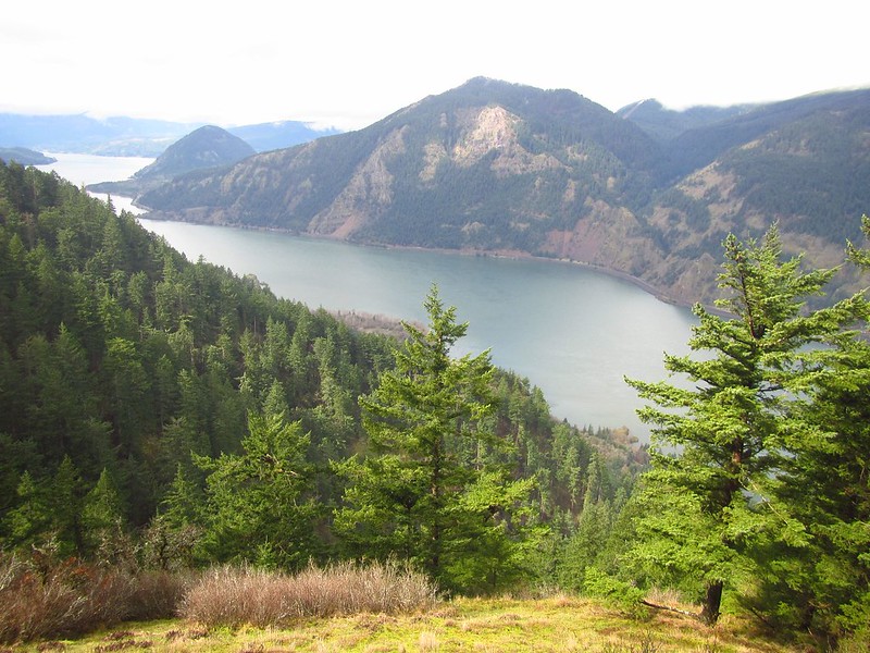
- I tracked down the good viewpoint described in the earlier editions of William Sullivan's guidebook. I'd managed to somehow miss this viewpoint before per the more direct route on the NE ridge. The viewpoint is right on the main trail a few switchbacks up from the upper Chetwoot junction. UTM 10 605594mE 5060945mN.
IMG_9679.JPG
- Broke off-trail and headed over west to check out a pinnacle I'd espied on a previous expedition up there. Mission successful -- add another viewpoint to the Wygant repertoire, tho' this one is harder to get to.
IMG_9682.JPG
- Followed old Chetwood Trail on the way back out. Unfortunately it seems the western side of the Perham Creek drainage has suffered significant slide activity in the last few years which has pretty much destroyed the trail with amazing numbers of fallen trees. It's a mess. The trail is effectively gone in that area and it will take a lot of work to reopen it. Not recommended currently. Broke off-trail and thrashed down to visit Perham Falls (nice 30ft+ waterfall located on Perham Creek at ~600ft elevation) - tho' getting there is a serious bear) and out the opposite side to finish up the loop. The eastern side of Chetwoot Trail is still intact.
IMG_9697.JPG
Perham Falls
In closing: yes, there actually are some good views on Wygant Peak. :)

Image
Last edited by mandrake on March 7th, 2016, 9:48 am, edited 2 times in total.

User avatar
Peder
Posts: 3401
Joined: May 28th, 2008, 10:02 pm
Location: Lake Oswego

Re: Three Ways to Wygant

Post by Peder » March 7th, 2016, 7:32 am

Nice Mandrake! I had forgotten about your Wygant ridges; indeed it seems like a good rainy day destination. Thank you.
Some people are really fit at eighty; thankfully I still have many years to get into shape…

User avatar
woodswalker
Posts: 835
Joined: November 25th, 2012, 4:51 pm

Re: Three Ways to Wygant

Post by woodswalker » March 15th, 2016, 7:37 am

I've been curious about this trail for awhile! Happy to see it revived. I had heard that they cleared trail partway up to Wygant Peak but not all the way. How was it?Thanks, Woodswalker

mandrake
Posts: 389
Joined: May 28th, 2008, 10:03 pm
Location: Portland, OR

Re: Three Ways to Wygant

Post by mandrake » March 15th, 2016, 8:46 am

It's okay. Expect numerous trees to climb under/over/around where the trail passes through the drainages which can get tedious - although many fallen logs have a notch cut out of them to provide footholds. Up on the ridgetop the trail was fine and obvious. Didn't bother going to the summit in my latest foray. See previous notes in this TR per poor trail design. Guess they wanted a really gentle grade all the way up. Much easier IMO to break off trail at the upper Chetwoot Jct and go directly up the ridge to the summit.

- The Chetwoot Trail on the west side of Perham Creek has been totally destroyed per major slide activity. Going to take a lot of work to reopen that side and there's no bridge at the upper crossing.

User avatar
woodswalker
Posts: 835
Joined: November 25th, 2012, 4:51 pm

Re: Three Ways to Wygant

Post by woodswalker » March 15th, 2016, 10:52 am

Thanks, that's super helpful. Now I just have to get over the flu so I can hike again.
Woodswalker

User avatar
kepPNW
Posts: 6411
Joined: June 21st, 2012, 9:55 am
Location: Salmon Creek

Re: Three Ways to Wygant

Post by kepPNW » April 10th, 2016, 8:23 am

mandrake wrote:
woodswalker wrote:I've been curious about this trail for awhile! Happy to see it revived. I had heard that they cleared trail partway up to Wygant Peak but not all the way. How was it?
It's okay. Expect numerous trees to climb under/over/around where the trail passes through the drainages which can get tedious - although many fallen logs have a notch cut out of them to provide footholds. Up on the ridgetop the trail was fine and obvious. Didn't bother going to the summit in my latest foray. See previous notes in this TR per poor trail design. Guess they wanted a really gentle grade all the way up. Much easier IMO to break off trail at the upper Chetwoot Jct and go directly up the ridge to the summit.
We went up yesterday, and found all the tales of doom and gloom on the trail to be near-entirely invalid anymore. Seemed to be in very good shape, with lots of recent work. Yeah, quite a few logs to hop, but none that were at all difficult, and all with good footholds. Might be worse on a wet day? The absolute worst for us was crawling under a few, and invariably picking up ticks in the process. (Each effing time! :evil:) Overall, I'd say the trail greatly exceeded all our expectations, both for hike-ability and the views. :D
mandrake wrote:The Chetwoot Trail on the west side of Perham Creek has been totally destroyed per major slide activity. Going to take a lot of work to reopen that side and there's no bridge at the upper crossing.
Glad we decided to not test it!
Karl
Back on the trail, again...

dspangler
Posts: 6
Joined: January 4th, 2015, 4:40 pm

Re: Three Ways to Wygant

Post by dspangler » May 23rd, 2017, 8:25 am

I am with Oregon State Parks--we have a youth crew who will be bucking out all 90 down logs on the Wygant Trail.

Hopefully, there will be some time to do some brushing starting from the top. Trail has some nice out sloping.

We plan to leave two large root wads due to time and priorities. We hope to hit this with a volunteer crew in the fall or spring.

And I only pulled four ticks off yesterday!

And yes the Chetwoot is still in sad shape. One day. . .

Post Reply