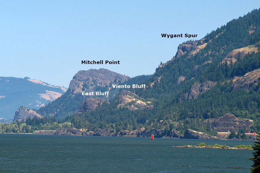
Three Ways to Wygant

Discussions and Trip Reports for off-trail adventures and rediscovering lost trails
mandrake
Posts: 389
Joined: May 28th, 2008, 10:03 pm
Location: Portland, OR

Three Ways to Wygant

Post by mandrake » December 8th, 2013, 9:07 pm

Wygant Peak is probably about one of the most unpopular trails in the Gorge. Probably because it has a reputation for no views, being overgrown, the bridges on Perham Creek are both out, loads of poison oak, and because no one else goes there. That said on various eastern Gorge excursions over the last year I've had my eye on Wygant for awhile. There are a couple of what look to be interesting rocky ridges on its northwestern flanks. Wygant's not that high and with the oak is relatively dormant in winter -- it was a destination on the list for a fall/winter adventure.
IMG_0031.jpg
Wygant views
A few sketches here of various routes:

11/03: Northeast Ridge
For being such an unpopular trail the Forest Service has a lovely sign advertising it at the Mitchell Point trailhead. The trail is easy to follow at first, along an as-yet unclaimed section of the Old Columbia River Hwy. Lots of blowdown across the trail - although someone (possibly on portlandhikers; is this the work of mcds?) has gone to a lot of work cutting notches in various trees to assist in climbing up and over. The bridge over Perham Creek is out (rather spectacularly broken into three sections) but one can follow up to the powerline corridor without any issues. Just before the powerline a short side trail leads to viewpoint. An old cable "fence" of sorts has been installed here to half-heartedly keep visitors from falling to their doom. Possibly this dates from when this was a much more popular area -- apparently there was once a campground at the mouth of Perham Creek with a trail that led up here. On reaching the powerline corridor the trail vanishes. I looked around for a bit, gave up, and thrashed on up the ridge to find the trail above... although on a future visit came on down the proper trail... it actually can be found at the terminus of the northeast ridge just above the last powerline tower... so cut left and follow the track if you're looking to follow the trail here.
IMG_0003.jpg
Mossy section of OCRH
IMG_0004.jpg
Sign crafted with care for the Chetwood Loop.
IMG_0008.jpg
The bridge is out!
IMG_0010.jpg
Old viewpoint
Followed the trail on up to around 1000' to where it meets the Chetwoot trail. One can follow this on a loop back towards the trailhead, whereas the main Wygant trail begins switchbacking upwards to the summit. The main trail above this point hasn't received maintenance in a long time; it's rapidly becoming a lost trail. To add insult to injury, Wygant seems to suffer from poor trail design. A lot of the switchbacks seem needlessly long / wandering - and routing the trail through steep drainages seems to be asking for more blowdown and washouts that will need constant repair. The southeast ridge is generally not that steep; it quickly became apparent that it was much easier just to break off and follow the ridge directly on up to the summit. Pretty open / easy all the way to the summit. William Sullivan notes another viewpoint around 1400' along the main trail although it is not on the southeast ridge -- must be on another a little further east. The forested summit is marked by a small rock cairn. No views, but push southwest from the summit about 300yrds to the top of a hanging meadow with views: Viento Ridge, Defiance, and partial Gorge. A reasonably good reward...
IMG_0024.jpg
Summit cairn
IMG_0025.jpg
Meadow views
11/03: South Ridge
I'd also wondered about the feasibility of following Wygant's southern ridge up to the Gorge crest which might allow longer traverses: From the summit, head out to the meadow viewpoint and drop down the southern ridge. Bit of brush around the meadow edge, but push through and the going is surprisingly easy to the saddle. Beyond the ridge dials up the thrash-o-meter until it's almost impenetrable beyond Pt. 2156. Fortunately it's short... getting onto the old road segment was a relief. Old campsite at road's end -- and followed it out. Road had a lot of blowdown, but became progressively easier until reaching the area of ORV trails along the crest. One can follow east to Post Canyon area / Mitchell Point or west to Mt. Defiance. The complex of (non-hiker) trails out here is pretty elaborate.

12/01: Northwest Ridge
Parked at Viento, headed in past the campground (watch for large mystery birdboxes - for woodpeckers? - and odd metal structure). Remnants of an old trail head through the poison oak paralleling the creek and leading to an old rock foundation of unclear purpose. From here broke off and thrashed on up the ridge. This ridge is the most scrambly of the lot - prolly best on a dry day. Very narrow in sections & few good scramble spots. Number of viewpoints. No real obstacles until around 1200' when the way is blocked by a 40ft cliff. Traversed right for a hundred yards to find a gully leading up through a weakness in the cliffband. Another viewpoint on top. Headed on up the ridge to enter the meadow southwest of the summit. Descended northeast ridge & back via the powerline corridor. Also found a small (maybe 2' x 3') natural arch on an arete adjacent to one of the powerline towers.
IMG_0009.jpg
Mysterious foundation along Viento Creek
IMG_0020.jpg
Scrambling up
IMG_0041.jpg
Atop the cliff
IMG_0044.jpg
Along the ridge
12/09: Northwest Direct
Beginning from the easternmost of the Viento Crags thrashed on up a gully just west of the second of Wygant's northwestern ridges. This route had an altogether different feel from the one just over to the west. No real scrambling, but still a few viewpoints now and again. I'd been intrigued by a spur route branching off down to the north having seen some rock formations down there on a previous foray, so took a detour to check them out. Involves losing some 600' in elevation, but t'was worth it... one descends down a large rocky arete to a great clifftop spot for lunch. Reminded me a bit of Wauna Point on a larger scale. Probably the single best viewpoint I've visited thus-far on Wygant. The rest of the ridge was similar to the others & pretty easy going. This one tops right out at the summit. Descended via northeast.
IMG_0020.jpg
Clifftop viewpoint
IMG_0024.jpg
Looking down the Gorge
All in all probably not enough to fully redeem Wygant, but there's definitely some interesting tidbits up there. Would be nice to see the main trail restored someday as it's rapidly becoming a lost trail. What would really help would be having some sort of loop option that one could do in concert with the summit - or a way to link into the greater Gorge trail system.

Addendum: number of other people seen on Wygant in all three adventures = zero.
Last edited by mandrake on May 26th, 2017, 8:32 am, edited 3 times in total.

User avatar
Peder
Posts: 3401
Joined: May 28th, 2008, 10:02 pm
Location: Lake Oswego

Re: Three Ways to Wygant

Post by Peder » December 8th, 2013, 10:13 pm

Thanks Mandrake - I was happy to see the map at the end of your post. I have only done the "normal" loop that used to be in Sullivan's guidebook. It seems that there are possibilities for a couple of fun loops. That bridge is really out now!
Some people are really fit at eighty; thankfully I still have many years to get into shape…

User avatar
RobFromRedland
Posts: 1095
Joined: May 28th, 2008, 10:03 pm

Re: Three Ways to Wygant

Post by RobFromRedland » December 9th, 2013, 5:57 am

Looks like an interesting, mostly off trail experience. How long was your whole trip?
Life is not a journey to the grave with the intention of arriving safely in a pretty and well-preserved body, but rather to skid in broadside, thoroughly used up, totally worn out, and loudly proclaiming: WOW! What a ride! - Hunter S. Thompson

mandrake
Posts: 389
Joined: May 28th, 2008, 10:03 pm
Location: Portland, OR

Re: Three Ways to Wygant

Post by mandrake » December 9th, 2013, 4:52 pm

How long was your whole trip?
The full traverse from Wygant to the crest & over to Mitchell was prolly most of a day. The other two ridge routes on Wygant are short & sweet; Wygant's only 2200' high, so can knock them out in a couple of hours.

User avatar
RobFromRedland
Posts: 1095
Joined: May 28th, 2008, 10:03 pm

Re: Three Ways to Wygant

Post by RobFromRedland » December 9th, 2013, 5:09 pm

I meant, mileage wise. It looks like it was a LONG day.
Life is not a journey to the grave with the intention of arriving safely in a pretty and well-preserved body, but rather to skid in broadside, thoroughly used up, totally worn out, and loudly proclaiming: WOW! What a ride! - Hunter S. Thompson

mandrake
Posts: 389
Joined: May 28th, 2008, 10:03 pm
Location: Portland, OR

Re: Three Ways to Wygant

Post by mandrake » December 10th, 2013, 12:51 pm

The ridgelines were maybe 4-6mi each; the Wygant-Mitchell Traverse was maybe 10-12?

User avatar
Chase
Posts: 1265
Joined: May 28th, 2008, 10:03 pm

Re: Three Ways to Wygant

Post by Chase » December 11th, 2013, 9:41 am

Hyperbole for how great this TR is!

mandrake wrote:To add insult to injury, Wygant seems to suffer from poor trail design. A lot of the switchbacks seem needlessly long / wandering - and routing the trail through steep drainages seems to be asking for more blowdown and washouts that will need constant repair.
Yes! As much as I admire the design of most of the trails in the CRG, this one is a real Edsel.
mandrake wrote:one of the biggest old growth trees I've ever seen in the Gorge proper... it's a monster. Someone cut through the tree ages back, but it's survived and still hanging on.
I shall seek out this tree! Thank you.

User avatar
AFLitt
Posts: 32
Joined: May 13th, 2011, 11:23 pm
Location: Orient, OR
Contact:

Re: Three Ways to Wygant

Post by AFLitt » April 14th, 2014, 8:30 am

Did the lower Wygant last Spring... Bridge is still passable, about the same shape as pictured. Ton of nasty blowdown past that, though. Nice view at the old viewpoint pictured.

I turned around there and made a spectacularly ill advised bushwhack down Perham Creek to the old HCRH section down there (with the old CCC sign "post").... There used to be a trail from the Wygant Trail down to the highway following Perham (that once was, apparently, an old road) and this was one of the main routes for the Wygant Trail in the early 70s.... According to a 1974 guidebook, after parking along the side of the freeway and walking in on the old HCRH:

"Continue along the roadbed [HCRH] and you will soon see some evidence that this was once a picnic area. Walk to the base of the cliff and turn left, entering the woods on a pair of tracks that soon dwindle down to a path. The trail continues up the west side of Perham Creek for about one-third mile, then it rises above the creek and switches back to the right."

The "switch back to the right" is now the current trail after it crosses Perham. Going down the west side of the creek to the HCRH was one of the worst 1/3 mile scrambles of my life. Nearly impassible and very treacherous due to all of the trees sliding down into the gully from above.

Quote from... Oral Bullard and Don Low. The Columbia Gorge: Short Trips and Trails. Beaverton, OR: The Touchstone Press. 1974. (87-88)
Recreating The Historic Columbia River Highway:http://www.recreatingthehcrh.org/

User avatar
Splintercat
Posts: 8333
Joined: May 28th, 2008, 10:03 pm
Location: Portland
Contact:

Re: Three Ways to Wygant

Post by Splintercat » April 16th, 2014, 6:44 pm

Well, that's cool, Mandrake! Missed this one the first time around. I've been eyeing that outcrop (I refer to it as Wygant Spur) as a possible new destination for a refurbished Wygant trail (including a loop to Viento), but have only scoped it out from the Viento Bluffs and more distant points in the area. Nice to see what the top looks like!

..and I'm assuming your photos are of the spot I'm referring to:

Image

@AFLitt: sad to hear that about the blowdown -- I suspected as much, given how the Starvation area was hammered a couple of winters ago. Part of the ecosystem, for sure... but hard on hikers!

Tom

mandrake
Posts: 389
Joined: May 28th, 2008, 10:03 pm
Location: Portland, OR

Re: Three Ways to Wygant

Post by mandrake » April 16th, 2014, 8:36 pm

@Splintercat: Thanks! Yes, I think what you have labeled as the Wygant Spur is marked as "viewpoint" on my map. I dropped down to it from above and it's neat cliff-top overlook. Reminded me of a larger version of the Wauna Point diving board. Wygant's definitely the black sheep of Gorge trails, but it's not beyond redemption. Yes, there actually are some views!

@AFLitt: Thanks for the report there -- I was wondering where the old trail down to the mouth of Perham Creek was at. Sounds like there's not much left. Wygant has definitely fallen from it's glory days.

Anyone ever explored upstream on Perham Creek? After the recent discovery of a falls on Viento Creek next door...

Post Reply