

Rogue River Hike
From Oregon Hikers Field Guide


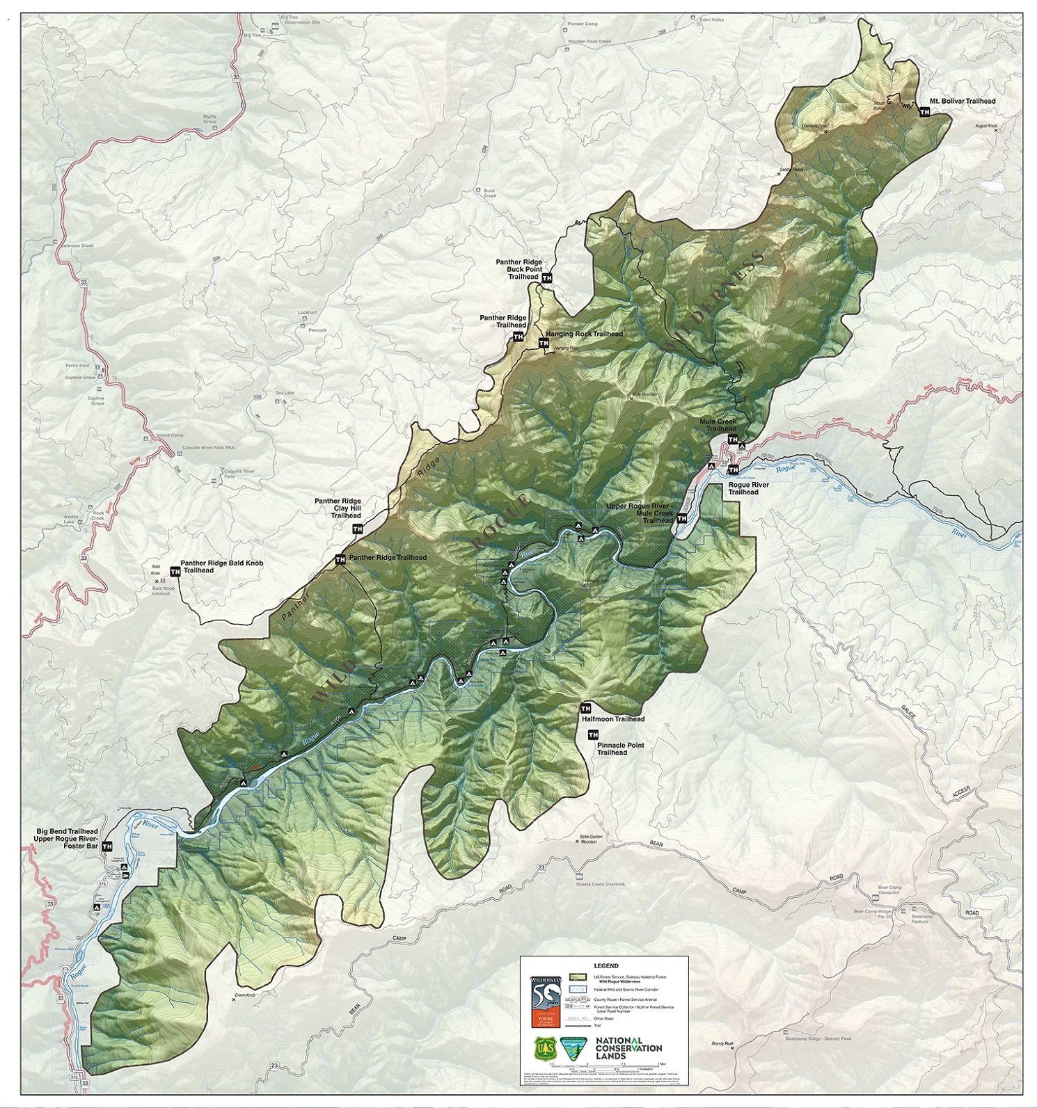
- Start point: Grave Creek Trailhead

- End point: Big Bend Trailhead
- Trail log: Rogue River Hike/Log
- Hike type: Traverse (one way)
- Distance: 39.8 miles
- Elevation gain: 3080 feet
- High point: 910 feet
- Difficulty: Difficult
- Seasons: Year round, but very hot in summer
- Family Friendly: Yes, in short sections
- Backpackable: Yes
- Crowded: Yes, from mid-spring into summer
|
|
|
Contents |
Hike Description
NOTICE: Road access to the Grave Creek Trailhead via Galice is currently closed due to extensive damage from the 2022 Rum Creek Fire. You can reach the trailhead from farther north, exiting I-5 at either Sun Valley or Wolf Creek.
This is a premier hike in Southern Oregon. The trail goes along the Rogue River, sometimes near the river and other times going a couple hundred feet above and offering great views. There is a 40-mile wild section with only one road access about in the middle.
You can do the full 40-mile hike, or you could just go from either end as far as you want, and then return to where you began. To do the 40 miles, you can drive two cars to Illahe, then backtrack one car to where you left the Rogue, turn left, and go the last 7.5 miles to Grave Creek. This route can be snowed in during the winter and early spring. Alternately, as you get near the trailhead, there are businesses and residences that have signs out front saying "shuttle".
There are several shuttle services for hikers and rafters/kayakers:
The trail is fairly good, though there are places where it is somewhat narrow with a steep drop on one side. In some places, it's somewhat rocky so you have to watch your step to avoid hurting your ankle. The trail crosses many streams, some with bridges, some necessitating a rock hop. In the winter, expect to encounter logs across the trail and slides that may be difficult to cross.
The Rogue River is better known for boating by rafts and motor boats. There are many challenging rapids and several good camping spots. A lottery system is used to limit the number of people using watercraft, but it's still fairly crowded during the season. From November to April, there aren't so many boaters. If you're into running rivers, this should definitely be on your list.
Hikers are allowed to use the boater campsites without having to reserve them, but you might not want to if they're crowded with boaters. There are also many hiker camps away from the river, but most of them are small with few flat level areas to sleep on. In the winter, there are so few backpackers that you can have your choice of campsites.
The climate here is much drier and warmer than in Portland. Since the trail stays below 900 feet elevation, it could be very nice here, even when it's snowy in the Gorge and on Mount Hood. Along the river, the vegetation is fairly sparse with lots of madrone trees. On the ridges above, there are pine and fir trees. Often, it is clear near the river with fog on the ridges above that burns off in the afternoon. The trees get much of their moisture from fog.
Sometimes there's snow here, and when the snow is melting and/or there are heavy rains, the river can flood, making the trail impassable. About half a mile from the Grave Creek Trailhead is a sign above the trail showing the river level in a recent flood. Check out the weather reports for Grants Pass or Gold Beach to get an idea of the current weather.
Watch for ticks, particularly in the summer. There are more ticks on the western half of the route. There is more grass along the trail in this section. The ticks wait on blades of grass until they can hop a ride on you or another mammal. Long pants and gaiters and perhaps tick repellant are recommended. After each day's hike, carefully inspect to see if any ticks are on you and remove them. You can get Lyme disease from a tick bite; typically there are a target shaped circular red rash and flu-like symptoms. If you manifest these symptoms, check in with a doctor who can recommend a treatment.
There are bears, especially around the western ten miles of the trail. Hang your food at least ten feet above ground and five feet away from trees. Use the provided bear-proof enclosures (electric fences, boxes, or cables/pullies) in the western section at Camp Tacoma, Tate Creek, Half Moon Bar, and Burns Creek. According to the BLM, bear problems aren't as bad as they used to be because of prevention efforts.
Watch out for poison oak, especially as you go further west. Also watch out for rattlesnakes from spring into fall.
Detailed Description
The trail starts at the parking area below the north end of the bridge across the Rogue at Grave Creek. Be aware that the parking area occasionally gets flooded. During the boating season, stay out of the way of boaters launching boats. The BLM is currently asking hikers to park in a pullout on the other side of the bridge, not near the boat ramp.
At mile 1.7 from the trailhead is a trail down to Rainie Falls. There is a large area near the river where you could camp. There's also a pit outhouse. To get a good view of the falls, you have to go on the trail on the south side of the river from Grave Creek.
At mile 3.2 is Whiskey Creek. Just before the creek is a campsite with an outhouse. This is probably the busiest campsite. If you want more privacy, go across Whiskey Creek and in the next 0.1 miles are several nice spots between the trail and the river. Right after the bridge over Whiskey Creek, there's a 0.1 mile trail up to an historic cabin. There are several buildings, but no camp spots or outhouse. There is a dirt road you can walk up about half a mile to a gravel road you can drive to and park at. Up to this point, expect to see a lot of day hikers. The crowds really thin out from here on.
At mile 3.7 is Big Slide Camp, where there is a large area that could accommodate many people. You'll get a nice view of the river with a cabin on the other side. There's also an outhouse. You won't find drinking water here, so you'll have to get it from Whiskey Creek or a small creek 0.4 miles to the west. Beyond here, there are hiker campsites every couple miles or so. These tend to be small, right next to the trail, with no good flat level place to camp. You can also get to the boater campsites, but sometimes the trail is way above so you have to take a steep, rough path down to them.
Some better campsites are:
- Bronco Creek is at mile 6.8. There's drinking water and 0.1 mile west of the creek is a decent place to camp a bit down from the main trail.
- Bunker Creek is at mile 8.9. The hiker camp is just at the west end of the bridge. A better spot is a bit east of the bridge below the trail. You can get drinking water here.
- At about mile 12 are the boater campsites at Horseshoe Bend and Lower Horseshoe. There are faint use trails down to them from the main trail, but it's about 200 feet down and quite steep.
- At mile 13 is Meadow Creek. Here you'll find drinking water, several campsites, and an outhouse.
- Zane Grey's Cabin is at mile 17.3. Zane Grey used this as a base for his fishing trips on the Rogue. It is now open to visitors.
- At 23 miles is the Rogue River Ranch. It is BLM owned, and the museum is open May through October. There's water, a bathroom, and an emergency radio. There is road access to here down a difficult gravel road. There is also Marial Lodge. Tucker Flat car campground is also here. It's not too busy, except on summer weekends, because of the difficult road access. The campground is also the trailhead for the Wild Rogue Loop Hike.
- Mule Creek Canyon is at mile 24. This is one of the more difficult sections of the Rogue, with a narrow channel and a lot of turbulence. It is also one of the most scenic sections of the hike.
- Check out Paradise Lodge at mile 27.4 from Grave Creek. You can get a shower, food, and a beer. It's only accessible by boat, trail, or airplane. They're only open in the summer, but you might find someone there year-round.
- At mile 30.2 is Brushy Bar Guard Station and campsite. The guard station is manned during the summer. There is a porch area you can use in the winter when it's not manned. You'll find a large camp area, outhouse, bear-proof units, and a drinking water stream at about mile 30.5.
- The last major campsite is Camp Tacoma at mile 32.7. There are a lot of boaters here during the season in nice sandy campsites right next to the river. You might prefer smaller campsites at Flora Dell Creek (hiker only) at mile 35 or Hick's Creek at mile 35.7. These are harder to find.
The eastern trailhead is Big Bend at mile 39.5. Nearby is the Foster Bar boat ramp, the most popular boat takeout point. There's a year-round campground here with a resident caretaker. If you parked your car overnight, you might want to park it at the boat ramp area rather than the Big Bend Trailhead and walk an extra half mile because with a resident caretaker it's safer.
For current info call:
- Rogue River eastern half - Grants Pass BLM 541-471-6500
- Rogue River western half - Gold Beach USFS 541-247-3600
Fees, Facilities, etc.
- Permits not required if you are hiking/backpacking unsupported by raft shuttles
- Wilderness regulations apply
- There may be fire restrictions; check for the latest news
- Store food in a bear canister or be prepared to hang it
Maps
- Maps: Hike Finder
- The Rogue River Trail (Bureau of Land Management)
- Wild Rogue Wilderness (BLM)
- Siskiyou Mountain Club: Wild Rogue Wilderness
- U.S. Department of Agriculture, Forest Service: Powers and Gold Beach Ranger Districts
- U.S. Department of Agriculture, Forest Service: Siskiyou National Forest
Trip Reports
- Search Trip Reports for Rogue River Hike
- Rogue River Trail from Foster Bar 5/8-5/11
- Rogue River 1/24/2023
- rogue river may 2022
- Rogue River trail from Grave Creek Trailhead
- Rogue River - Dec 6, 2020
- Rogue River Trail 27/30-Apr-2015
Related Discussions / Q&A
- Search Trail Q&A for Rogue River Hike
Guidebooks that cover this hike
- 100 Hikes/Travel Guide: Southern Oregon & Northern California by William L. Sullivan
- Trips & Trails: Oregon by William L. Sullivan
- Hiking Southern Oregon by Art Bernstein & Victor Harris
- Hiking Oregon's Southern Cascades and Siskiyous by Art Bernstein
- 76 Day-Hikes Within 100 Miles of the Rogue Valley by Art Bernstein
- Extraordinary Oregon! by Matt Reeder
- Hiking Oregon's Geology by Ellen Morris Bishop
- Backpacking Oregon by Douglas Lorain; revised by Becky Ohlsen
- 100 Classic Hikes in Oregon by Douglas Lorain
- Oregon's Wilderness Areas by George Wuerthner
- 75 Hikes in Oregon's Coast Range & Siskiyous by Rhonda & George Ostertag
- Oregon Campgrounds Hiking Guide by Rhonda & George Ostertag
- 100 Oregon Hiking Trails by Don & Roberta Lowe
- HIking Oregon by Donna Lynn Ikenberry
- Oregon Hiking by Sean Patrick Hill
- Pacific Northwest Hiking by Scott Leonard & Sean Patrick Hill
- Oregon Coast: Camping & Hiking by Tom Stienstra & Sean Patrick Hill
- From Sea to Summit: The R.A.D. Guide to Hiking in Curry County, Oregon by the R.A.D. Outdoor Club
More Links
- Rogue River National Recreation Trail #1160 (USFS)
- Oregon Rogue River Trail (USFS)
- Rogue River National Recreation Trail (Bureau of Land Management)
- Rogue National Wild & Scenic River Permits (Bureau of Land Management)
- Rogue River Trail Backpacking Guide (Clever Hiker)
- Autumn Backpacking: the Rogue River Trail (Artemis Hikes)
- Rogue River Trail (Southern Oregon) 27/30-Apr-2015 (Boots on the Trail)
- Rogue River Trail (Jay's Journeys)
- Rogue River Trail Thru hike (Eric's Hikes)
- Rogue River Trail - Day 1 (Outdoor Project)
- Rogue River Trail - Day 2 (Outdoor Project)
- Rogue River Trail - Day 3 (Outdoor Project)
- Rogue River Trail - Day 4 (Outdoor Project)
- Hiking on the Wild & Scenic Rogue River Trail (Morrisons Rogue River Adventures)
- Hiking Adventure: Exploring the Rogue River Trail & Beyond (Morrisons Rogue River Adventures)
- Rogue River Trail – Big Bend to Clay Hill – 05/14/2021 (wanderingyuncks)
- Rogue River Trail from Grave Creek (The Adventure Continues)
- Rogue River Trail (Wild & Scenic Rogue River)
- Hike of the Week: Rogue River Trail (Paria Outdoor Products)
- Rogue River Trail (Oregon California Coast)
- Hiking the Rogue River Trail – A River Guide’s Perspective (NW Rafting)
- Hiking 40 Miles on the Rogue River (Bears Stole Our Food) (Jonathan Yentch)
- Trail of the Week: Rogue River Trail, Oregon (Podium Runner)
- "Lower Rogue River Trail reopens" (Mail Tribune)
- Rogue Valley (Northwest Wildflowers)
Contributors
- retiredjerry (creator)