Muddy Fork Loop Hike
From Oregon Hikers Field Guide
- Start point: Ramona Falls Trailhead
- End point: Bald Mountain
- Hike Type: Lollipop loop
- Distance: 13.8 miles
- Elevation gain: 2585 feet
- High Point: 4,591 feet
- Difficulty: Difficult
- Seasons: Summer into fall
- Family Friendly: No
- Backpackable: Yes
- Crowded: Yes, near Bald Mountain and Ramona Falls
Contents |
Description
NOTICE: As of Summer 2021, the stretch of the Timberline Trail between the Muddy Fork and the junction with the Yocum Ridge Trail is much more difficult because of numerous large downed trees. The trail is now open, but expect to take your time. This route is not recommended for those with a full overnight pack.
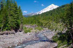
This lower-level loop using the Pacific Crest and Timberline Trails can be done early in the season before alpine trails have melted out. The route takes in some of the more interesting features of Mount Hood’s west side, including Ramona Falls as well as short side trips to the stunning view from the top of Bald Mountain and the slowly decaying Upper Sandy Guard Station. In recent years, the volatile main channel of the Sandy River and its Muddy Fork have destroyed permanent bridges, so crossing those streams can be an adventure and ideally should be attempted only after a period of dry weather. Also note that this section of the Timberline Trail has several slide areas that could be tricky to cross before repair crews reach them in the late spring. The steep meadows and lush springs of the Bald Mountain and Yocum Ridges make this a prime wildflower hike in late spring/early summer.
This loop is about 1 ½ miles shorter if you begin the hike at the Top Spur Trailhead.
Take the wide, sandy trail leading up from the southeast corner of the parking area. You will be hiking among stunted mountain hemlock, Douglas-fir, and lodgepole pine on a carpet of moss, pinemat manzanita, and reindeer lichen. Beginning in about 1780, pyroclastic flows from Mount Hood buried the Sandy River, which continues to change its course as it carves through the soft strata. Pass the first of at least three glacial river crossing signs warning about safe passage when waters are high (There has been more than one drowning death in the area.) Come to the Sandy River-Ramona Falls Trailhead Trail Junction, and proceed past a large boulder to a Stop sign, where you’ll need to fill out a wilderness permit.
Hike onward to the steep eroding bank of the Sandy River. The trail joins an alder-lined old road bed. Reach the bank of the river again, and then descend to the Sandy River Crossing. A bridge is no longer provided here, so you’ll need to pick one of the logs strewn across the spate or attempt a ford. This crossing can be dangerous and is easiest from mid-summer to early fall. The trail continues on the opposite bank and winds through an alder-colonized debris fan. Drop in and out of a gully, and then head up parallel to the river in shady woods. Come to the Pacific Crest-Sandy River Trail Junction, and go left. The trail soon reaches a footbridge over Ramona Creek and heads up the bank of the creek. At the well-signed Ramona Falls-Pacific Crest Trail Junction, keep left and pass a campsite.
Head down to the Muddy Fork Crossing on Pacific Crest Trail. In 2016, the best crossing was along two large downed trees, the upper tree with a rope handhold. Once safely on the opposite bank, hike through a salmonberry thicket, and enter a lush old growth forest of western red-cedar, hemlock, and Douglas-fir with an understory of rhododendrons, huckleberry, vine maple, and Oregon grape. As the trail ascends, both silver and noble fir soon enter the mix, and the single-note calls of varied thrushes echo through the trees. In an old burn, pass through a dense woodland of rather spindly conifers, and make two big switchbacks. Cross a small talus slope with its resident population of pikas before stepping over a small brook issuing from a spring. Make five more switchbacks in a huckleberry/rhododendron understory (The rhodies bloom profusely here in June), and reach a ridge crest. Hike up the broad crest among large western hemlocks. Soon after the trail levels, come to the four-way Pacific Crest-Timberline-Top Spur Trail Junction with its map kiosk. Take the Timberline Trail leading off to the right.
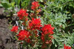
Pace off 150 yards, and find an unmarked trail leading up to the left: this will take you 0.3 miles to the summit of Bald Mountain. Head up through a dense growth of huckleberries, and switchback. The upper-level forest has a bear-grass carpet, and you will be stepping over several downed snags. Reach a huckleberry clearing to get a glimpse to the north of Mount Adams. After passing the foundation stones of the old Bald Mountain lookout, make your way through a thicket of mountain ash, alder, and bitter cherry to reach the stunning viewpoint of Mount Hood, with the Sandy Glacier and the valley of the Muddy Fork framed by the Bald Mountain and Yocum Ridges. A steep meadow blooming with penstemon, buckwheat, wallflower, paintbrush, and lupine tumbles below you to where the Timberline Trail snakes along the side of the ridge.
After returning down the user path to the Timberline Trail, make a left. Rise gently in silver and noble fir forest, and pass a wilderness sign. Break out into an open meadow with a frontal view of Mount Hood before traversing a thimbleberry thicket. Make a descending traverse alternating steep meadows with thickets. Pass the Timberline-Bald Mountain Cutoff South Trail Junction: this short bypass connects with the Timberline Trail on the other side of the Bald Mountain Ridge in a quarter of a mile. Cross a couple of small streams, the second one at a slide. At a boggy seep, the erect flower stems of bog orchids are arrayed like an offering of tapers. After passing over another slide area, hike through a slope forest dominated by mature silver firs. Cross two more slides on this easily eroded pyroclastic slope, and step over a small creek. Rise a little, and then descend to step over a creek with a small waterfall above the trail.
Reach the 2002 debris piles at the wide wash of the Muddy Fork, and follow the trail through young cottonwoods and alders to the first Muddy Fork Crossing on Timberline Trail: this is usually just a rock hop from the beginning of summer. Look up to the looming ramparts of a citadel-like structure at the head of the valley with a tall waterfall to its left. Ahead, pouring down the steep slopes of Yocum Ridge are three seasonal falls between 500 and 750 feet in height. Continue to wind through thickets, and cross a channel that is usually dry by June. Drop down a shallow gully to follow a recently created stretch of trail up to a crossing of the south branch of the Muddy Fork, which has carved a new channel through the alders. Follow a trickling stream down to the main course of the Timberline Trail where it tunnels through a bower of Sitka alder. Pass two campsites, and head up a slope in old growth forest with thickets of devil’s club, salmonberry, and thimbleberry and an understory of wood fern and Solomon plume. The trail keeps to a level contour and crosses the first of several slide areas in this transit of Yocum Ridge. Get a view across the valley to Bald Mountain from one such opening. Cross several small creeks, and pass some sizeable silver and noble firs before making a gradual descent to the Timberline-Yocum Ridge Trail Junction.
Keep straight here as the Timberline Trail descends a slope in a rhododendron alley. Pass over a rotting boardwalk in an area of springs and skunk-cabbage shaded by a canopy of Douglas-fir, western hemlock, and red-cedar. Hiking under a rock face, you’ll see Ramona Creek burbling below and soon reach the junction with the Ramona Falls Trail #797. Keeping left, you’ll cross the footbridge over the creek and take in the view to Ramona Falls’ splashing cascade down a face of columnar basalt. On any weekend, you’ll no doubt be joining throngs of other hikers who have come up from the Ramona Falls Trailhead (see the Ramona Falls Loop Hike).
Continue on the Timberline Trail, and pass through a stock fence near a horse hitch. The trail drops among stunted mountain hemlocks and lodgepole pines to the Pacific Crest-Timberline Middle Trail Junction. For the short detour to the Upper Sandy Guard Station, go left here down to a bench. Before dropping to the alder thickets on the Sandy River debris plain, look for a steep trail leading up to a bench on your left. The Guard Station, now all shuttered up, is atop this bench and out of sight. The 1935 structure is unique in its log/stone wall construction, but has now lost part of its roof, and most of the windows are boarded. A hantavirus warning is posted on the door, but one open back window allows you (as of 2016) a peek inside.
Return to the Pacific Crest-Timberline Middle Trail Junction, and keep left as the trail cuts into a pyroclastic slope. The forest, with a salal understory, becomes shadier as you get views down to the Sandy’s wide debris channel. Pass out of shady old growth to the stunted Old Maid Flat forest. The trail drops off the bench again and wends down among rhododendrons to the Pacific Crest-Sandy River Trail Junction. Keep left here to make the Sandy River Crossing and return to the trailhead.
Fees, Regulations, etc.
- Northwest Forest Pass (or America the Beautiful Pass) required at trailhead. Pass must be acquired beforehand as they are not sold at the trailhead.
- Self-issued wilderness permit
Maps
- Maps: Hike Finder
- Green Trails Maps: Government Camp, OR #461 and Mount Hood, OR #462
- Adventure Maps: Mt. Hood Area
- U.S. Department of Agriculture, Forest Service: Zigzag Ranger District
- U.S. Department of Agriculture, Forest Service: Mt. Hood National Forest
- National Geographic Trails Illustrated Map: Mount Hood Wilderness
- National Geographic Trails Illustrated Map: Mount Hood
- Discover Your Northwest: Mt. Hood National Forest North
Trip Reports
- Search Trip Reports for Muddy Fork Loop Hike
- Ramona/PCT/Timberline loop -- 05/31/2021
- Ramona Falls Loop from Top Spur
- Muddy Fork Loop 06-25-16
- Mt. Hood PCT loop: Ramona Falls, Muddy Fork, Bald Mountain
- A Loop around the Muddy Fork – 2014/08/03
- Muddy Fork Loop Sept 7 – 8 2013
- Bald Mountain – Muddy Fork – Ramona Loop
- Muddy Fork-Ramona Falls Loop from Top Spur TH (7/2/09)
Related Discussions / Q&A
- Search Trail Q&A for Muddy Fork Loop Hike
Guidebooks that cover this hike
- Day Hiking Mount Hood: A Year-Round Guide by Eli Boschetto
- Day and Section Hikes Pacific Crest Trail: Oregon by Paul Gerald
More Links
- Sandy River Trail #770 (USFS)
- Pacific Crest Trail (Zigzag) (USFS)
- Timberline National Historic Trail #600 (USFS)
- Ramona Falls Trailhead (USFS)
- Hike of the Month: Muddy Fork Loop (Trailkeepers of Oregon)
- Ramona Falls & Bald Mountain Loop (Backpacker)
- Mt Hood solo hiker drowned while crossing swollen Sandy River (Traditional Mountaineering)
- Discovering Bald Mountain (WyEast Blog)
- Muddy Fork (WyEast Blog)
- Ramona Falls (Northwest Waterfall Survey)
- Ramona Falls (Oregon.com)
- Upper Sandy Guard Station Cabin (Wikipedia)
- Upper Sandy Guard Station (WyEast Blog)
- The Upper Sandy Guard Station (Restore Oregon)
- Bald Mountain (Mt. Hood) (Northwest Wildflowers)
Page Contributors
- bobcat (creator)


