

Lost Corral Hike
From Oregon Hikers Field Guide


,_Lost_Corral_Trail,_Cottonwood_Canyon_S.P..jpg)


- Start point: J.S. Burres Trailhead

- End point: Lost Corral
- Hike type: In and out
- Distance: 10.1 miles
- Elevation gain: 75 feet
- High point: 555 feet
- Difficulty: Moderate
- Seasons: All year
- Family Friendly: No
- Backpackable: No
- Crowded: No
|
|
Contents |
Hike Description
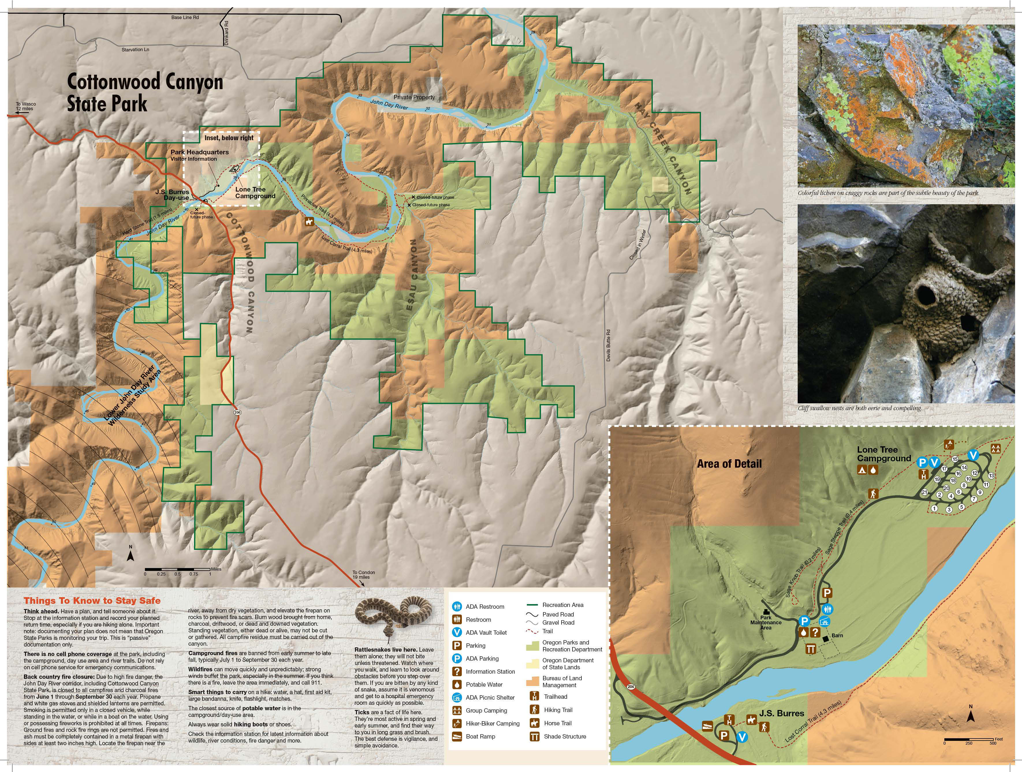
In Oregon’s second-largest and one of its newest state parks, a jeep track leads along the Gilliam County side of the John Day River to access a cattle corral nestled under a cliff of columnar basalt. The journey to the corral involves alternating sagebrush flats with rocky traverses below high cliffs that host nesting raptors and cliff swallows. Part of this hike takes you along a tranquil side channel of the river. A short loop from the corral finishes the hike unless you want to take to the high ridges for an off-trail excursion. Note that this trail is sometimes closed in winter/spring because of high water.
Pass through the archway and follow a gravel track across a sagebrush flat. The track curves to the left and passes around a gate. You’ll get good views of the Cottonwood Canyon State Park’s buildings, including the Murtha Ranch Barn, on the opposite side of the river. Walk by a lone juniper and reach the river verge at a gate and hackberry tree under a high basalt wall. A barbed wire fence runs between the jeep track and the river here. Pass through another gate opposite the park campground. Reach a broad flat at a bend in the John Day River and get good views of the cliffs across. Leaving the flat, the track rises on a rocky tread under cliffs of columnar basalt. In spring, cliff swallows are building their mud nests here and there is constant activity. Pass a white alder tree and a willow-blanketed bar on the river.
Now you’re hiking along a lush, quiet channel of the river lined by golden current, mock orange, and wild rose. Look above you at slopes of balsamroot. Across the river, a gooseneck peninsula juts into a curving meander. Pass a couple of ranch arches at a draw and then hike a sandy track across a grassy flat to the base of high basalt cliffs. American kestrels nest in these cliffs; also, look carefully to see the ‘Let Me Insure Your House’ advertisement. Walk below the rugged mouth of Rattlesnake Canyon, with its intermittent waterfall, and reach the Lost Corral.
Take a while to explore the corral area, with its cattle chute and pens and shady hackberry: these useful trees, members of the cannabis family, are near the northern end of their range here. Passing through the corral, follow the road track to where it splits: going right leads up broad Esau Canyon. Instead, keep left at the signage for the Esau Loop Trail and pass through a gate. The trail leads up a grassy sagebrush bench to offer views of the river, the tip of the Gooseneck Peninsula, and the red cliffs at the next bend. Descend to the river, keeping an eye out for rattlesnakes and the ever-present Scotch thistles, which only leaf out fully in the summer. Reaching the river, bear left on a wide grassy track to reach an archway with a Three Rivers Conservancy sign. Don’t go through the archway (unless you want to return to the Lost Corral); instead, keep right long the fence line to reach the jeep track that will take you back to the J.S. Burres Trailhead.
Off-trail option: Esau Canyon Loop
- Distance from Lost Corral: 4.3 miles (loop)
- Elevation gain: 1,010 feet
- High point: 1,460 feet
Walk through the Lost Corral on the ranch track and, rounding the corner of the low cliff, scramble up to the ridge above. A fence follows this ridge to the right of the ridge crest all the way up. It’s better to cross the fence and then hike up on or next to a very eroded cattle track that essentially keeps to the crest in a landscape of fescue and sagebrush. Phlox, milkvetch, and desert parsley bloom up here in the spring. Get views to the right down to the John Day Canyon. At a small spring, you’ll pass a clump of ancient sagebrush with trunks almost a foot across! Small rock outcroppings appear as the vegetation gets thinner and balsamroot becomes a feature. On the western horizon, windmills, powerlines, and the snowy top of Mount Adams appear. Looking east, you’ll see verdant farm fields above the canyon slopes. Soon, you find an old track that proceeds near the crest of the ridge. The track descends to the left and then splits at the Esau Ridge Junction.
Go down to the left to descend into Esau Canyon, getting views up one of the east forks of Esau Creek. Step over a barbed wire gate and switchback three times before reaching creek level. The creek may run here into summer and you’ll hear frogs chirping. Follow the creek on a farm track through a gate at a cattail swamp that bustles with bird activity; warbling blackbirds, scurrying partridges, and cooing doves. After the cattails, the creek disappears into a dry wash that blooms with pungent desert parsley and spurred lupine in the spring. Crossing the wash, you’ll follow the tread past a couple of junipers at an intermittent spring on the slope above. Pass through a fence line at a shady hackberry tree; here there’s also a galvanized water tub fed by a spring. Reach the mouth of the canyon at the Lost Corral and return the way you came.
Maps
- Maps: Hike Finder
- Cottonwood Canyon State Park (Oregon State Parks)
- Bureau of Land Management, Fish & Wildlife Service, National Park Service, USDA Forest Service: Lower Deschutes & John Day Rivers
Regulations or restrictions, etc
- Dogs on leash
- Share trail with cyclists and horses
Trip Reports
- Search Trip Reports for Lost Corral Hike
- Cottonwood Canyon trails - 2023-4-27
- Lost Corral Trail - Cottonwood Canyon - 3-31-2022
- Eastern Gorge Area Alive & Well
- Cottonwood Canyon - Lost Corral Trail - 2-2-21
- Eastern Gorge area - Deschutes & Cottonwood Canyon 11/4 & 11/9/20
- CottonwoodCanyon 7-1-2020 Lost Corral Trail
- Three, three hikes in one report
- Cottonwood Canyon State Park - 2018.05.26
- Cottonwood Canyon – Lost Corral Trail – 5-19-16
- Lost Corral (Cottonwood Canyon State Park) 04-09-16
- Cottonwood Canyon – Lost Corral Trail 1-18-16
- John Day River – Cottonwood Canyon State Park – 11/27
- Cottonwood Canyon 4-29-2014
- Cottonwood Canyon – March 8, 2014
- Some Central Oregon Hikes
Related Discussions / Q&A
- Search Trail Q&A for Lost Corral Hike
- Cottonwood Canyon State Park Backpacking????
- Cottonwood State Park is to open next year
Guidebooks that cover this hike
- none
More Links
- Cottonwood Canyon State Park (Oregon State Parks)
- Lost Corral Trail – Cottonwood Canyon State Park – 05/30/21 (wanderingyuncks)
- Hike of the Month: The Lost Corral in Cottonwood Canyon (Trailkeepers of Oregon)
- Backpacking Oregon's Cottonwood Canyon : Lost Corral Trail (backcountry post)
- Cottonwood Canyon State Park (Wikipedia)
- “Cottonwood Canyon State Park continues adding amenities, even green grass” (Oregon Live)
Contributors
- bobcat (creator)