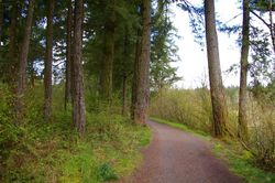
Lacamas Heritage Trail Hike
From Oregon Hikers Field Guide
- Start point: Camas Heritage Park Trailhead
- End point: Goodwin Road Trailhead
- Hike Type: In and Out
- Distance: 7.0 miles
- Elevation gain: 30 feet
- High Point: 210 feet
- Difficulty: Easy
- Seasons: All year
- Family Friendly: Yes
- Backpackable: No
- Crowded: Yes, on weekends
Contents |
Hike Description
This wide, flat trail, which runs along one shore of Lacamas Lake, attracts lots of joggers, walkers, and cyclists on nice days. There are a number of interpretive signs along the trail. This hike can be done all year, but the best times are when water levels are high. Native wildflowers bloom in profusion along the trail in spring. In late summer, after water levels on the lake drop, there can be a slightly unpleasant odor from the mudflats. For a longer day, you can connect with the trails in Lacamas Park (the Round Lake Loop Hike and the Lacamas Creek Hike) as well as the Washougal River Greenway Loop Hike. On a nice day, you'll encounter a fair number of joggers, walkers, and cyclists on this trail.
The trail begins across the access road to the left of the restrooms, but you should head down to see Lacamas Lake first. This first part of the Heritage Trail is paved and it winds around under Douglas-firs and through an open area before becoming gravel. There are quarter-mile markers all along the trail. At a junction where a spur leads up to Lacamas Drive, keep right along the cedar-lined shore of the lake. Indian-plum, holly, ivy and elderberry are also very much in evidence. Skunk-cabbage blooms trailside in early spring. Pass above an old cistern and then a small observation deck on the right. Hike through a grove of alders shading a carpet of bleeding-heart, skunk-cabbage, and trillium. Come to a boat launch area and go left on the paved road, and then make a right to take up the gravel trail again. The park to the left is exclusively for the use of residents of the Lacamas Shores neighborhood.
The trail skirts a grassy stretch of parkland with a small cattail pond. Large homes loom up on the bluff. At a junction, keep right along the shore. The houses become larger, including one huge mansion. The links of Camas Meadows Golf Club can be seen to the left. Pass through a grove of large Douglas-firs. Toothwort, snow queen and Oregon grape flower trailside in the spring. Large grand firs rise above. Walk over two wide bicycle bridges in marshland as, to the right, the lake narrows to a slough. Pass into an oak woodland and then cross another bridge. You'll see Lacamas Creek running to the right. New development appears on the left. Pass under powerlines with some fenced ponds beneath them. Reenter oak woods and notice the golf course again to the left. Finally, the trail heads between a fence and a private driveway to the Goodwin Road Trailhead, which has restrooms.
Maps
- Maps: Hike Finder
- Lacamas Heritage Trail (Clark County Parks)
- City of Camas Parks (City of Camas Parks & Recreation)
Fees, Regulations, etc.
- Park hours 7:00 a.m. to dusk.
- Dogs are permitted on leash.
- Restrooms at trailheads.
Trip Reports
- Search Trip Reports for Lacamas Heritage Trail Hike
Related Discussions / Q&A
- Search Trail Q&A for Lacamas Heritage Trail Hike
Guidebooks that cover this hike
- Urban Trails: Vancouver by Craig Romano
- Take a Walk: Portland by Brian Barker
- 100 Hikes: Northwest Oregon by William L. Sullivan
- Best Trail Runs: Portland, Oregon by Adam W. Chase, Nancy Hobbs, and Yassine Dibboun
- Wild in the City: Exploring the Intertwine edited by Michael C. Houck and M.J. Cody
- Best Bike Rides: Portland, Oregon by Lizann Dunegan & Ayleen Crotty
- Biking Portland by Owen Wozniak
More Links
- Lacamas Lake Regional Park (Clark County Parks)
- Lacamas Heritage Trail (Washington Trails Association)
- Lacamas Heritage Trail (TrailLink)
- Lacamas Heritage Trail (The Intertwine)
Contributors
- bobcat (creator)


