

Fort Columbia Loop Hike
From Oregon Hikers Field Guide


- Start point: Fort Columbia Trailhead

- End point: Scarborough Hill
- Hike type: Two loops
- Distance: 4.3 miles
- Elevation gain: 940 feet
- High point: 820 feet
- Difficulty: Easy
- Seasons: All year
- Family Friendly: Yes
- Backpackable: No
- Crowded: No
Contents |
Hike Description
The mouth of the Columbia River, from the Spanish-American War until the end of World War II, was defended by three forts: Fort Stevens in Oregon and Fort Canby and Fort Columbia in Washington. Fort Columbia became surplus in 1947 and was transferred to the Washington State Park system. Before the U.S. Army arrived, this area at Chinook Point saw the arrival in 1792 of Captain Robert Gray, who named the Columbia River after his ship, the Columbia Rediviva. The Lewis and Clark Expedition camped near here, at Station Camp, for several days in November 1805, before shifting to the site of Fort Clatsop. Fort Columbia is now one of the Lewis and Clark National and State Historical Parks. You can walk the gun emplacements and buildings here (some of them are sometimes open as a museum and interpretive center) and then take the leafy trail up Scarborough Hill, where you’ll get few views but find solitude among the giant Sitka spruce and dense salal and salmonberry thickets. Note that windstorms in the past decade have destroyed some of the trail system on the hill; longer loop options shown in older guidebooks are no longer possible.
Behind the parking area, there are interpretive signs giving an introductory history of the fort, a plan of the site, and a trail map. Take in the views from here over Battery Ord and the Guard House to Sand Island and Cape Disappointment. Saddle Mountain in Oregon can also be seen from the parking area. Walk down the road and take a right for the Guard House, which has restrooms, and look over Battery Jules Ord, constructed between 1896 and 1898. Then walk down the road a little more, passing the gravel Gun Battery parking area, and turn in (left) at Battery 246, never completed and decommissioned in 1945, where you see one of two six-inch guns that were brought here in 1993 from Newfoundland. These guns are identical to the ones that would have been installed here (Battery 246 did serve as a Washington State Department of Civil Defense Emergency Operating Center from 1960 - 1970). Walk around to the second gun, and then inspect Battery Crenshaw, which was armed with three three-inch rifles between 1900 and 1920. The guns are no longer here, but you can inspect their rusting mounts. Just to the west is Battery Murphy, the most active of the three completed gun emplacements at Fort Columbia as it was manned in three wars from 1900 to 1945. The two six-inch disappearing guns are gone, but you can explore the magazine room, shell room, engine room, and ammunition hoists.
From Battery Murphy, walk down to the wood building below, formerly the ordnance storehouse and now an active theater. A grassy path, shaded by red alder and Sitka spruce, leads between the blackberries to a four-way junction. Go left here to descend to the isolated pocket beach at Chinook Point, cluttered with driftwood and rimmed by seaweed covered rocks. At low tide, you can scramble right across the rocks to get views back to Saddle Mountain and across to the mouth of the Columbia and Cape Disappointment. Back at the junction, the path to your left takes you to a viewpoint above Chinook Point. Return to the junction one more time, and descend to a grassy expanse. The Searchlight Powerhouse is on your left and, just beyond it, a dark opening overhung with vines leads into the New Mine Casemate, the operations center for triggering the mines that had been strung across the river in times of war. This dank, eerie place still exhibits the remains of washstands, electricity cables, and a water heater.
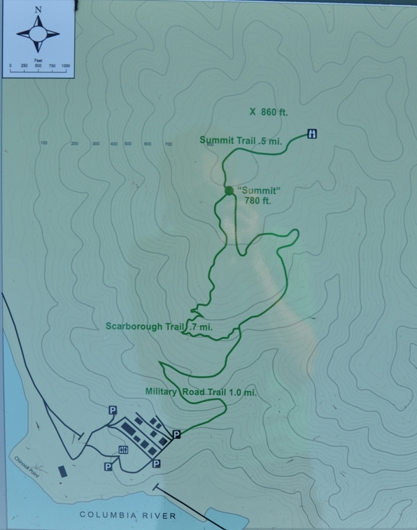
Walk out to the entrance arch and then up the entrance road. You’ll pass a plaque on your right that commemorates the designation of the site as a National Historical Landmark in 1961. Pass the RV/Bus Parking Area and walk along the street behind the lower row of officers’ residences. Turn left at the end of the row and hike uphill with the former hospital building, now Scarborough House (James Scarborough was the first white settler north of the Columbia River). Keep straight up the hill, passing a last picnic table, and reach a grassy track extending into the woods: the Military Road Trail.
This old road track, which led to observation posts, ascends gently under alder and big-leaf maple. Large Sitka spruce begin to appear in the hillside forest. A spur leads off to the right and eventually reaches a fenced concrete dam on Canyon Creek: entry forbidden. Keep left on the road track and pass the remains of two observation stations (entry also prohibited here) and then, at a massive spruce, get a view over the Columbia. The road switchbacks at the junction with the abandoned Comcomly Trail and rises through a salmonberry/elderberry thicket. Pass through a sunny opening and reach the junction with the Scarborough Trail. (Note: on a wet day, you might wish to continue up the Military Road here, as dense, dripping thickets overhang the trail and soak you from the top down.)
Hike on the level on a spur of the Military Road. This ends soon and becomes a true foot trail that winds up through the Sitka Spruce forest with a smattering of western hemlock and bountiful red huckleberry bushes in the summer. Tunnel through a lush thicket and traverse a slope, noting many more impressive Sitka spruce. Eventually reach the junction with the old Canyon Creek trail and keep left although, again, you could give this a miss on a wet day. This trail used to lead down the drainage of Canyon Creek, but now only about half a mile remains. Follow a contour, passing thorugh another tunnel of salmonberry, before dropping to the edge of a windfall corridor at the saddle between Scarborough Hill’s two peaks. Here a sign says: “Trail Closed: Please Turn Around!”
Walk back to the junction and proceed left down the Military Road to close the loop by descending through more spruce/hemlock woods and the road bed hemmed in by salmonberry, elderberry, and the drooping vines of big root. Keep left at the next junction, and descend to the fort area. At the top of the parking area, you can take the short grassy track down to the site of the fort’s powerhouse and telephone switchboard. A 1913 generator is on exhibit within the powerhouse.
Maps
- Maps: Hike Finder
- Fort Columbia Hiking Map (WillhiteWeb.com)
- Adventure Maps: NW Coast Trail Map & Guide
Fees, Regulations, etc.
- Park hours 8 a.m. to dusk
- Dogs on leash
- $10 day use or Discover Pass
- Picnic tables, restrooms, interpretive signs
- Officers' houses for rent
Trip Reports
- Search Trip Reports for Fort Columbia Loop Hike
Related Discussions / Q&A
- Search Trail Q&A for Fort Columbia Loop Hike
Guidebooks that cover this hike
- Day Hiking: Olympic Peninsula by Craig Romano
- 100 Hikes: Oregon Coast by William L. Sullivan
- Washington State Parks: A Complete Recreation Guide by Marge & Ted Mueller
More Links
- Fort Columbia Historical State Park (Washington State Parks)
- Lewis and Clark National Historical Park (National Park Service)
- Fort Columbia (FortWiki)
- Battery Ord (FortWiki)
- Battery 246 (FortWiki)
- Battery Crenshaw (FortWiki)
- Battery Murphy (1) (FortWiki)
- Chinook Point (National Park Service)
- Fort Columbia State Park (WillhiteWeb.com)
- Fort Columbia State Park (Washington's Long Beach Peninsula)
- "Fort Columbia, Washington" (The Columbia River: A Photographic Journey)
- Chinook, Chinook Point, and Scarboro Hill, Washington (The Columbia River: A Photographic Journey)
- “James Scarborough occupies Chinook Point on the Columbia River on December 1, 1843” (HistoryLink)
- Fort Columbia State Park (Outdoor Project)
- Fort Columbia State Park - Scarborough Hill (Washington Trails Association)
Contributors
- bobcat (creator)