Cairn Basin
From Oregon Hikers Field Guide
- Hikes to this location
- Cairn Basin from Top Spur Hike (TH | <— —> | LOG)
- Cairn Basin via Mazama Trail Hike (TH | <— —> | LOG)
- Hikes including this location
- Weather forecast: NWS/NOAA
- Maps: Oregon Hikers Maps Google Maps
- Latitude, Longitude: 45.40397, -121.72371
- Elevation: 5640 feet
Description
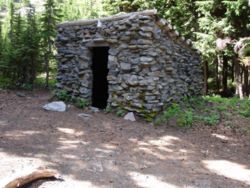
Cairn Basin, home of a shelter and several campsites, is on the north side of Mount Hood, between McNeil Point and Wy'East Basin. It is 4.7 miles from the Top Spur Trailhead if you go via the face of Bald Mountain, 4.1 miles if you go direct, and 4.2 miles from the Vista Ridge Trailhead. The shelter is open on one side, there's a fireplace with chimney, and though the roof drips when it's raining, it's still a good place to keep in mind in stormy weather.
Unlike Elk Cove or Wy'East Basin, Cairn Basin is mostly timbered, if sparsely. The widely spaced trees create enough openness for camping, but enough shelter to break the wind. There are meadows on both sides of the timbered camping area that bloom in late July and August, with several species blooming at once.
The Timberline-Eden Park Loop Junction is just 100 feet or so west of the shelter. Since the 2011 Dollar Lake Fire, this junction has been unmarked. It is on the east bank of the little stream that runs behind the shelter.
This is a popular camping spot in the summer, but it's a big enough area so you're not on top of each other. If it's really busy, try going to the left (northwest) or keep going to the other end and go left (northwest). Another possibility is to take the trail to the right, up past the shelter, some distance from the other sites.
More Links
- Cairn Basin Shelter
- Cairn Basin Stone Shelter
- Cairn Basin (Dean's Place)
- Cairn Basin (Beyond>)
- Eden Park & Cairn Basin (Mt. Hood) (Northwest Wildflowers)
Page Contributors
- Splintercat (Tom Kloster) (primary)
- retiredjerry


